Turn on suggestions
Auto-suggest helps you quickly narrow down your search results by suggesting possible matches as you type.
Cancel
- Home
- :
- All Communities
- :
- Products
- :
- ArcGIS Pro
- :
- ArcGIS Pro Ideas
- :
- Layer Symbology should include Label settings
Options
- Subscribe to RSS Feed
- Mark as New
- Mark as Read
- Bookmark
- Follow this Idea
- Printer Friendly Page
- Report Inappropriate Content
Layer Symbology should include Label settings
Follow this Idea
1296
7
10-13-2011 02:17 PM
Status:
Closed
- Mark as New
- Bookmark
- Subscribe
- Mute
- Subscribe to RSS Feed
- Permalink
- Report Inappropriate Content
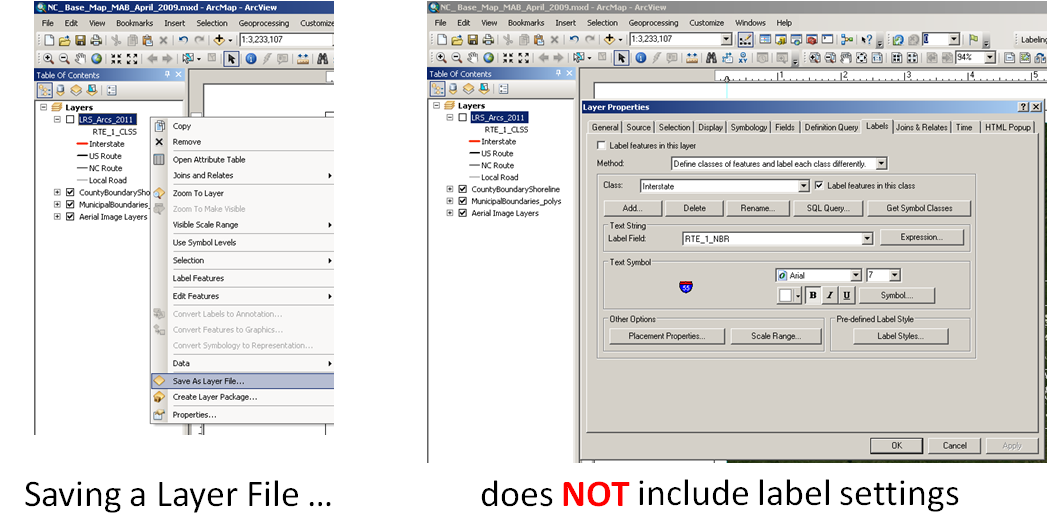
Roadway files include many symbol classifications (Interstate, US Highway, State Highways, Local Roads, Ramps, etc.), each of these have a different symbology (color, thickness, label) AS WELL AS a different label (Interstate shield, US Highway shield, State Highway shield, local road name, or <null>).
When saving symbology as a layer file (.LYR) the label settings are not included, so I have to re-work label settings every time. It's very frustrating and a waste of time.
When saving symbology as a layer file (.LYR) the label settings are not included, so I have to re-work label settings every time. It's very frustrating and a waste of time.
7 Comments
- Mark as Read
- Mark as New
- Bookmark
- Permalink
- Report Inappropriate Content
Um, I guess I'm not understanding the request, but that is one of the things that saving a layer file does... I use a roads layer file daily that has the label symbology pre-defined. When you save a layer file it saves every setting in all of the tabs.
- Mark as Read
- Mark as New
- Bookmark
- Permalink
- Report Inappropriate Content
If you add the lyr file as a layer both the symbology and label properties are present. However you can not import labels from a layer file, like you can do with symbology. I agree that the ability to import label properties from a lyr file would be very helpful.
- Mark as Read
- Mark as New
- Bookmark
- Permalink
- Report Inappropriate Content
I made an Add-In for this. (Import labels from Layer )
It is available for download here: http://www.arcgis.com/home/item.html?id=dbb7be9d2c1c491e8c1a067ffd58aea8
JAKUB SISAK photography
To see my photography please visit:
facebook | fine art america | 500px | Flickr

It is available for download here: http://www.arcgis.com/home/item.html?id=dbb7be9d2c1c491e8c1a067ffd58aea8
JAKUB SISAK photography
To see my photography please visit:
facebook | fine art america | 500px | Flickr
- Mark as Read
- Mark as New
- Bookmark
- Permalink
- Report Inappropriate Content
This functionality would be great to have built in!
- Mark as Read
- Mark as New
- Bookmark
- Permalink
- Report Inappropriate Content
Huge timesaver for me if Esri implements this idea. I would be super excited about this one.
- Mark as Read
- Mark as New
- Bookmark
- Permalink
- Report Inappropriate Content
XTools has Copy?Paste tool for symbology and labels
- Mark as Read
- Mark as New
- Bookmark
- Permalink
- Report Inappropriate Content
Status changed to:
Closed
Hi - In ArcGIS Pro layer files bring across the label information - placement and symbol properties. If you are seeing issues please contact Technical Support.
thanks
Wendy
You must be a registered user to add a comment. If you've already registered, sign in. Otherwise, register and sign in.