- Home
- :
- All Communities
- :
- Products
- :
- ArcGIS Pro
- :
- ArcGIS Pro Questions
- :
- Re: Close gaps between polygons?
- Subscribe to RSS Feed
- Mark Topic as New
- Mark Topic as Read
- Float this Topic for Current User
- Bookmark
- Subscribe
- Mute
- Printer Friendly Page
- Mark as New
- Bookmark
- Subscribe
- Mute
- Subscribe to RSS Feed
- Permalink
- Report Inappropriate Content
I'm manually editing some polygons and for the polygons that share a common boundary, I need them to have the exact common boundary and I cannot get them to close the gaps.
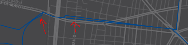
I've tried using the Align Features tool Modify Features tool reference—ArcGIS Pro | ArcGIS for Desktop but it is not working... Instead of closing the gap, I end up with a bigger gap or only the gap, opposed to removing the gap and having a common boundary as in the rightmost par of the clipping: (different results based whether I start from the left or the right)


PS. I have the Map Topology ENABLED

Any ideas on how to make them share a common boundary?
Solved! Go to Solution.
Accepted Solutions
- Mark as New
- Bookmark
- Subscribe
- Mute
- Subscribe to RSS Feed
- Permalink
- Report Inappropriate Content
Hey Hector,
Have you tried the Eliminate tool? It is supposed to close the slivers between polygons. I also found this post here with methods that could be useful for your situation. Hope this helps!
- Mark as New
- Bookmark
- Subscribe
- Mute
- Subscribe to RSS Feed
- Permalink
- Report Inappropriate Content
Hi Hector,
I would recommend creating a geodatabase topology. With a topology you can set the cluster tolerance. Any vertices less than the cluster tolerance will snap together.
- Mark as New
- Bookmark
- Subscribe
- Mute
- Subscribe to RSS Feed
- Permalink
- Report Inappropriate Content
looks just like the tool I need to use. I just need to figure out how to use it in ArcGIS Pro since it is only available via Python...
Set Cluster Tolerance—Data Management toolbox | ArcGIS for Desktop
- Mark as New
- Bookmark
- Subscribe
- Mute
- Subscribe to RSS Feed
- Permalink
- Report Inappropriate Content
Hector, you can still use arcmap for data preparation, you should realize that the transition is in progress
Introduction to editing topology—ArcGIS Pro | ArcGIS for Desktop and there are differences
- Mark as New
- Bookmark
- Subscribe
- Mute
- Subscribe to RSS Feed
- Permalink
- Report Inappropriate Content
Hey Hector,
Have you tried the Eliminate tool? It is supposed to close the slivers between polygons. I also found this post here with methods that could be useful for your situation. Hope this helps!
- Mark as New
- Bookmark
- Subscribe
- Mute
- Subscribe to RSS Feed
- Permalink
- Report Inappropriate Content
many thanks for your valuable ideas! It got me on the right direction.
I managed to make it a topology layer and then using the Align Edge Align topology edges—ArcGIS Pro | ArcGIS for Desktop tool. Quite magical, but manual, since there are only a few Slivers I needed to get rid of, it was no problem at all.
- Mark as New
- Bookmark
- Subscribe
- Mute
- Subscribe to RSS Feed
- Permalink
- Report Inappropriate Content
I inherited layers that divided each county into "Routes". The previous work had no precision and the routes had gaps and overlaps. I tried several different techniques and found the following to be most expeditious and precise. I used the Align Tool, but it removed some curves and precise angles that I had put much time into creating.
Assuming the drawing shows a Northern Polygon and a Southern Polygon being separated by a Road.
- Select a separation line. If the map is cluttered or the cut is complex, create a new layer for the cutlines by tracing the Streets Layer or by using a definition query on the Streets Layer to only show the needed roads.
- Redraw the Northern polygon so that it completely overlaps the road. Do the same with the Southern polygon.
- Select both Polygons and use the Cut Polygons Tool to trace along the road. This will slice both polygons along the same road, using the same vertices, and create two new "waste" polygons.
- Delete the newly created polygons.
Note: for further precision, divided highways and interstates can be used by selecting the North/South or East/West line or create a copy then use Collapse Dual Lines To Centerline Tool to create a single line down the middle for splitting polygons.