- Home
- :
- All Communities
- :
- Products
- :
- ArcGIS Pro
- :
- ArcGIS Pro Questions
- :
- Re: Display .grd and .tab files in Arcgis.
- Subscribe to RSS Feed
- Mark Topic as New
- Mark Topic as Read
- Float this Topic for Current User
- Bookmark
- Subscribe
- Mute
- Printer Friendly Page
Display .grd and .tab files in Arcgis.
- Mark as New
- Bookmark
- Subscribe
- Mute
- Subscribe to RSS Feed
- Permalink
- Report Inappropriate Content
Good afternoon.
I have an application that exports a .grd and associated .tab file.
The file contains RF signal levels over and area with four ranges of signal strengths of different colors.
How can this be converted or displayed in Arcgis?
The Grid file displays to a degree. It shows three bands as RGB.
On the map it appears as one color.
I suspect the .tab file is needed for the correct color formatting.
The .grd and .tab import fine into mapinfo.
I would be fine with a .shp file format as well but don't see a conversion tool in Arcgis or Qdis for .grd and associated .tab to a .shp file
regards, David
- Mark as New
- Bookmark
- Subscribe
- Mute
- Subscribe to RSS Feed
- Permalink
- Report Inappropriate Content
The application i'm exporting from has the following file output options:
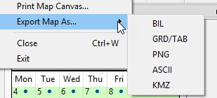
Would be happy to use any one that works for arcgis import.
-David
- Mark as New
- Bookmark
- Subscribe
- Mute
- Subscribe to RSS Feed
- Permalink
- Report Inappropriate Content
The ASCII might give you one that might be converted to a raster using Ascii to Raster but any of them are essentially a 'picture' (BIL, PNG) so if you want just to have that, then you have options
- Mark as New
- Bookmark
- Subscribe
- Mute
- Subscribe to RSS Feed
- Permalink
- Report Inappropriate Content
I don't know if this reply is too late... but, if you expand the GRD file in the catalog, you should actually see 4 different bands, Bands 1-3 are the RGB values that are telling ESRI how to display the layer, and Band 4 is actually the RSRP/signal values for the grd. If you are looking to change the color scheme or get the signal value then you should just add in only band 4 to the mapping window and you should see the raster representing the actual rsrp values.