- Home
- :
- All Communities
- :
- Products
- :
- ArcGIS Pro
- :
- ArcGIS Pro Questions
- :
- Re: LAS dataset Location issue
- Subscribe to RSS Feed
- Mark Topic as New
- Mark Topic as Read
- Float this Topic for Current User
- Bookmark
- Subscribe
- Mute
- Printer Friendly Page
LAS dataset Location issue
- Mark as New
- Bookmark
- Subscribe
- Mute
- Subscribe to RSS Feed
- Permalink
- Report Inappropriate Content
Hi guys,
I am having a set of LAZ files downloaded from a Government website, converted them into LAS using 3D Sample tools (https://www.arcgis.com/home/item.html?id=fe221371b77940749ff96e90f2de3d10) and tried to load it into ArcGIS pro by creating a LAS Dataset. I used the UTM projection of the region(Rotterdam, Netherlands). When I am adding the Las Dataset into the Scene I am getting it near by Africa instead of Europe. I couldn't able to find out the problem, the problem is with projection I used the projection tools given in the 3D Sample tolls but nothing changed the result. When I didn't give any coordinate system the data is coming in North America.
Kindly help me to narrow down the issue and what other tools can be tested with the data?
- Mark as New
- Bookmark
- Subscribe
- Mute
- Subscribe to RSS Feed
- Permalink
- Report Inappropriate Content
Arun,
Is it possible that something has gone wrong with the conversion from LAZ to LAS?
If your data is showing up around Africa, then it likely sounds like a projection issue (I'm guessing it's around the 0, 0 coordinate in the system you're using).
Can you reproject to a different system for that part of Europe? Do you tools allow you to reproject?
- Mark as New
- Bookmark
- Subscribe
- Mute
- Subscribe to RSS Feed
- Permalink
- Report Inappropriate Content
Hi Adrain,
Reprojecting LAS Dataset using Transformation tools is not possible. And there is no other tools that I found out for the reprojection of LAS files also.
If there is any way to reproject las files or lasd file it would make the process simple.
- Mark as New
- Bookmark
- Subscribe
- Mute
- Subscribe to RSS Feed
- Permalink
- Report Inappropriate Content
Normally I assign the coordinate system at the lasd level, after loading the las files into it.
I have rarely met a las file that has had coordinate information already attached to it.
So, you should really go back to that Gov agency and find out what the correct coordinate system for their data actually is.
But as Adrian says, if it is pitching up off the Nigerian coast, then maybe it is in GCS (geographic) and not a projected system. That is quite unusual.
- Mark as New
- Bookmark
- Subscribe
- Mute
- Subscribe to RSS Feed
- Permalink
- Report Inappropriate Content
Hi Neil,
As Adrian suggested is there any chances there would be a error taken place during the process of LAZ to LAS and please recommend which tool that you use for the usual conversion of laz to las?
- Mark as New
- Bookmark
- Subscribe
- Mute
- Subscribe to RSS Feed
- Permalink
- Report Inappropriate Content
I have used the really excellent LasTools tools from here :
- Mark as New
- Bookmark
- Subscribe
- Mute
- Subscribe to RSS Feed
- Permalink
- Report Inappropriate Content
I am currently having the same issue. I know my data is in a NAD83 State Plane in the US, but when I add my .las to ArcPro, it is displaying off the coast in Africa. I create an .lasd and specify the coordinate system I want, but it is still in the wrong location.
Any tips?
Thanks,
Zach
- Mark as New
- Bookmark
- Subscribe
- Mute
- Subscribe to RSS Feed
- Permalink
- Report Inappropriate Content
If your data is appearing somewhere here :
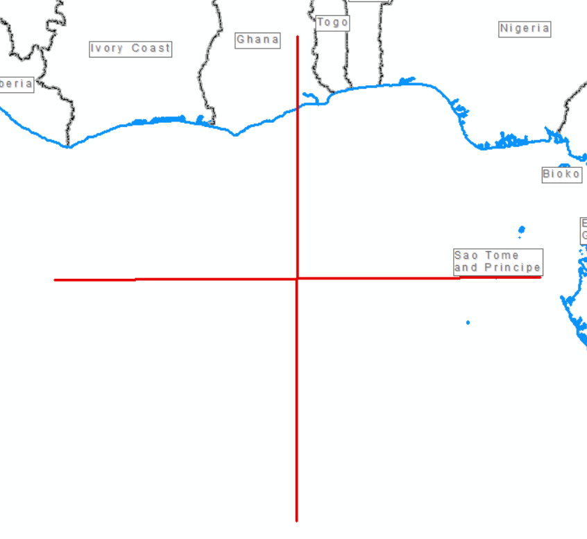
Then the data is in degrees and not really in a Stateplane projection.
Check you the extents by looking at the properties of the lasd
- Mark as New
- Bookmark
- Subscribe
- Mute
- Subscribe to RSS Feed
- Permalink
- Report Inappropriate Content
It is close to there (lands somewhere in Togo). I converted my data from a .pts file in Autodesk RECAP where I know it is in a state plane projection to .las file (via LasTools). Maybe the coordinate system is lost in the data transfer?