- Home
- :
- All Communities
- :
- Products
- :
- ArcGIS Pro
- :
- ArcGIS Pro Questions
- :
- Re: low visual quality of 3D scene
- Subscribe to RSS Feed
- Mark Topic as New
- Mark Topic as Read
- Float this Topic for Current User
- Bookmark
- Subscribe
- Mute
- Printer Friendly Page
low visual quality of 3D scene
- Mark as New
- Bookmark
- Subscribe
- Mute
- Subscribe to RSS Feed
- Permalink
- Report Inappropriate Content
I have a DSM with a pixelsize of 0.02 meter that was created from images captured by a UARSF and an orthophoto that was created from this DSM and RGB images captured during the same flight.
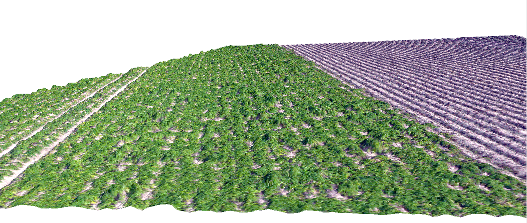
When I view this data in ArcScene I get a detailed 3D view of the potato field that clearly shows the height differences within the field, the bare ridges on the right, the tracks through the potato field on also the individual potato plants. (see Potatos3D_ArcScene.png)
When I view the same data in ArcGIS Pro (prerelease), most of the 3Ddetails are not visible, the tracks through the field on the left are there, but the individual potato plants are not visible anymore. The same applies to the bare ridges on the right, the 3D pattern is gone but there seems to be a random 3D pattern that has no relation with the DSM. (see Potatos3D_ArcGISPro.png)
Also the 3D patterns change when navigating the scene, potato plants pop-up and dissappear at random.
The scene was created using the LocalScene template, I've added the dsm file as an elevation surface to the world and selected thes surface as the source for the orthoimage.
Are there any settings that I can apply to improve the visual quality of the 3D scene and get a correct rendering of the DSM?
Henk
- Mark as New
- Bookmark
- Subscribe
- Mute
- Subscribe to RSS Feed
- Permalink
- Report Inappropriate Content
Henk,
Can you share the data and SXD either here or through a technical support incident? I'd like to take a look.
One thing to keep in mind is that ArcGIS Pro uses variable levels of detail to render 3d views - this is done to conserve memory and resources. ArcScene can display everything at full resolution all the time, but as you may have noticed it can quickly run out of memory or graphics card memory when displaying complex scenes. To avoid this, the terrain engine in Pro displays appropriate LOD close to you, and the detail falls off as you move away from the camera.
Regardless, please share us your data so we can replicate your repro steps and investigate.
Regards,
Jeremy W.
- Mark as New
- Bookmark
- Subscribe
- Mute
- Subscribe to RSS Feed
- Permalink
- Report Inappropriate Content
Hi Jeremy,
I can’t share the data on the forum because it’s for internal use only. I can give you a copy but it should only be used by esri for testing purposes, please don’t share it further.
I’ve created a zipfile with the data and an ArcScene project. The orthophoto is resampled to 0.01 m resolution, I did that because I wanted to see 0.02 m pixels in ArcScene and it seems that ArcScene resamples the overlay with a factor 2, so with a 0.01 m pixel source file you’ll see a 0.02 m pixel in ArcScene. This way I get maximum visual detail in ArcScene.
You can download the zip file from:
https://sendit.wur.nl/Download.aspx?id=6940e28e-4b65-4d15-9d95-2a58ec191e7f
The file(s) will expire in 5 days and will be available for a maximum of 20 downloads.
I like the approach of ArcGIS Pro using the LOD method to be able to display large scenes. But when you’re viewing from close range, the 3D view does not represent the terrain features as they are, it’s a lowres representation and also changes a lot when making just small adjustments to the viewpoint.
I hope this dataset will be of use,
Regards,
Henk
Henk Kramer
Centrum Geo-informatie
Alterra
Wageningen
tel. 0317-481816
Van: Jeremy Wright
Verzonden: donderdag 9 oktober 2014 19:18
Aan: Kramer, Henk
Onderwerp: Re: - low visual quality of 3D scene
GeoNet <http://jiveon.jivesoftware.com/wf/click?upn=Dg1s4x8le7Lmxv8KWGaqo8h7SGfRSMkw-2FpvHGF9-2FW3rK-2Bvs1kL9-2FnG6jjf2NZhrLDz0M-2BrY-2By9IaziQEKVk3Hg-3D-3D_hPvzF1oQ8Ol6eJxHweimCRyx5WqRpxl2JPVdSxTTnyat53LeyRs0xym9A2tEsGkAJXs5ydUGtjQBykp2SK35e-2BnM-2BkP-2Bq6cC7086gDFnuF0PfSxdoyM3e16cZtvgnNNLEJETdoQso7ZbDzU-2B965grhuxKvilcPVJmM6H0XShjOdA13FPGkghjdOHBC53xU1sP7Nhxy0VXUHPCRReaOsJiC-2F8IaHQWEFtAtjbKPFYYKg5l5dOSGyvqZHI4g-2F0QoIY-2F5TPFr111bi0K8ZwQ8U3S4GfCS7R9zdubYDz2vTS6Xzt9SAHgTqvPrFkcvqiX-2B2L>
low visual quality of 3D scene
reply from Jeremy Wright<http://jiveon.jivesoftware.com/wf/click?upn=Dg1s4x8le7Lmxv8KWGaqo7A4BXwO9PY1WvQ5cXCtK4-2F4NQlcvX-2BJ9GaFiCLRnDeyM3pGZfIL-2FEjycnqRRK3wJSNk4Mm1S9GLWvOMxUwgEhcu9dQhNcjpuWlxnUI2Qc-2BR_hPvzF1oQ8Ol6eJxHweimCRyx5WqRpxl2JPVdSxTTnyat53LeyRs0xym9A2tEsGkAJXs5ydUGtjQBykp2SK35e-2BnM-2BkP-2Bq6cC7086gDFnuF0PfSxdoyM3e16cZtvgnNNLp1rYrV01OgGfBukazGrh55L8Q3Auul7HAJn-2FymnPwOxOcZTiI6vwfCcAZJ58MBPXeOZ1tqT7S8A0MX1fuuwsCv7qj543kp0ccaknkwuhXqDg-2BPPOXOKwKwmFHrompw491x-2FoZnjNZUmq0Pv5jT8vitl3LhJOGwSutLGYuAAQwYpq10MpkiexjMHtAmD8CIK1> in ArcGIS Pro - View the full discussion<http://jiveon.jivesoftware.com/wf/click?upn=Dg1s4x8le7Lmxv8KWGaqo0VQjeJBYpG9HGC8QZBT-2FEwiwPZPyzIN7CWIQoyTxDHCFAmtgM-2FmfIVHgu22VgdmWIJAnaopBTlTT4nDepBhsx4-3D_hPvzF1oQ8Ol6eJxHweimCRyx5WqRpxl2JPVdSxTTnyat53LeyRs0xym9A2tEsGkAJXs5ydUGtjQBykp2SK35e-2BnM-2BkP-2Bq6cC7086gDFnuF0PfSxdoyM3e16cZtvgnNNL5MgWbe6qFxG-2BWT7q-2B-2FdgqktxdgPIq2aKhsKUzPM0vd81Wjqu2-2B-2FrbPKj1cw2crlULAGGHqrcKa6VR-2FjnFU0rrPILZwiMkpbqZh1LJx-2BIVFaFZmtasYgrta-2FLznTq7oofglY81yrOX7gImlGCJEdspMtlJvo9ZXghlkwgAGeP8JXy-2FbGXL5rlyUCXYHuv9FZQ>
- Mark as New
- Bookmark
- Subscribe
- Mute
- Subscribe to RSS Feed
- Permalink
- Report Inappropriate Content
Henk,
Thanks for the repro data. I logged a defect with the appropriate developer for investigation.
regards,
Jeremy W.
- Mark as New
- Bookmark
- Subscribe
- Mute
- Subscribe to RSS Feed
- Permalink
- Report Inappropriate Content
sorry, here's the tracking number for you:
BUG-000082592