- Home
- :
- All Communities
- :
- Products
- :
- ArcGIS Spatial Analyst
- :
- ArcGIS Spatial Analyst Questions
- :
- Re: ArcGIS Pro Nibble tool problem
- Subscribe to RSS Feed
- Mark Topic as New
- Mark Topic as Read
- Float this Topic for Current User
- Bookmark
- Subscribe
- Mute
- Printer Friendly Page
- Mark as New
- Bookmark
- Subscribe
- Mute
- Subscribe to RSS Feed
- Permalink
- Report Inappropriate Content
I have a wawe intensity raster with gaps (NoData), and I want to Nibble the NoData pixels from neighbouring pixel values (wawe intensity values) in ArcGIS Pro, using a separate sea water mask covering the NoData areas (pixels in dark blue). The two raster are 32 bits floating point rasters and have identical raster statistics, extents and projection. In addition all the required env. variables seems to be correctly defined. The Nibble tools performs well without any error messages. BUT the output is a raster with values from -3.4 to +3.4. The same problem occurs when I use the Focal Statistics tool... same problems with integer rasters, Nibble output 0-255. The floating output raster has the same size 2.8 GB, so there are some data in there.. I have also built new pyramids and calculated raster statistics without any improvements..
Any ideas why this is so, and how to solve this problem? 
Best regards,
Frank
Solved! Go to Solution.
- Mark as New
- Bookmark
- Subscribe
- Mute
- Subscribe to RSS Feed
- Permalink
- Report Inappropriate Content
Yes, both are single band rasters. And I used the 3rd parameter PROCESS_NODATA as I would like to nibble values into the NODATA-pixels of the wawe raster, represented by the associated NNODATA mask. Thanks a lot for helping me with this problem!
- Mark as New
- Bookmark
- Subscribe
- Mute
- Subscribe to RSS Feed
- Permalink
- Report Inappropriate Content
The only difference between the two raster is that the NoData mask raster is not compressed, whereas the wawe-raster is compressed with LZ77
- Mark as New
- Bookmark
- Subscribe
- Mute
- Subscribe to RSS Feed
- Permalink
- Report Inappropriate Content
Frank,
I suggest trying outputting to tiff or grid. Over the years, I have had all kinds of nasty bit depth problems with file geodatabase rasters. I should mention it has gotten better over the years. But, I have found raster processing more efficient and robust when working with file based formats. Map Algebra uses .tif as its intermediate format of raster processing workflows (not fgdb). I will often get my processing done, and then as a final step copy to fgdb if I need it there (carefully setting options for bit depth and nodata).
- Mark as New
- Bookmark
- Subscribe
- Mute
- Subscribe to RSS Feed
- Permalink
- Report Inappropriate Content
Dear Curtis!
Thanks for advising me to use GRIDs.
I solved the problem (went back to ArcGIS 10.17 as I am still most familiar with that SW).
- First I converted all NoData wawe-pixels to 0 to allow the Nibble tool too do the interpolation (within the coastal zone area).
- I then used this converted layer as the input raster to the Nibble-tool.
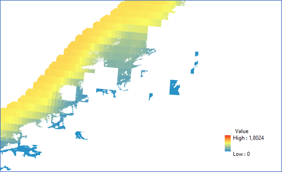
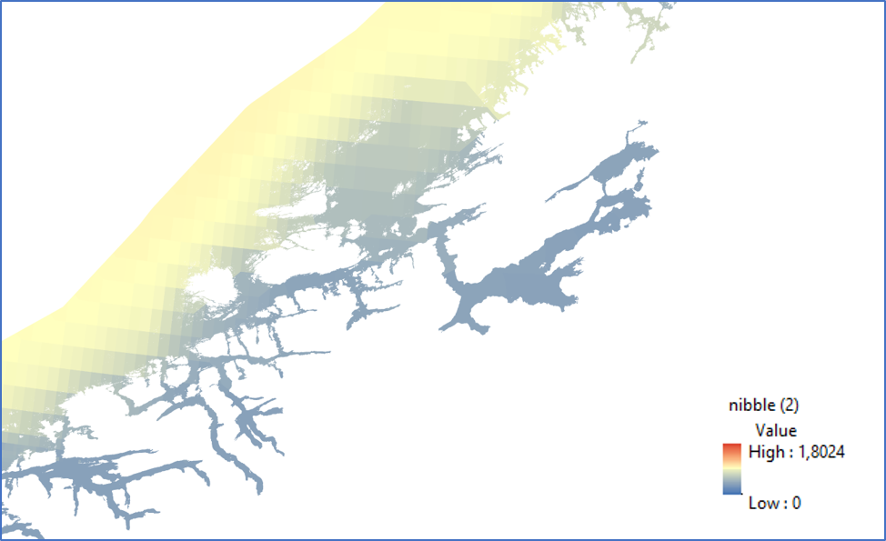
- The original wawe-raster (with its NoData pixels) aim as the input raster mask. The Nibble output gave me the intended result, as visualized in the enclosed images.
Best regards,
Frank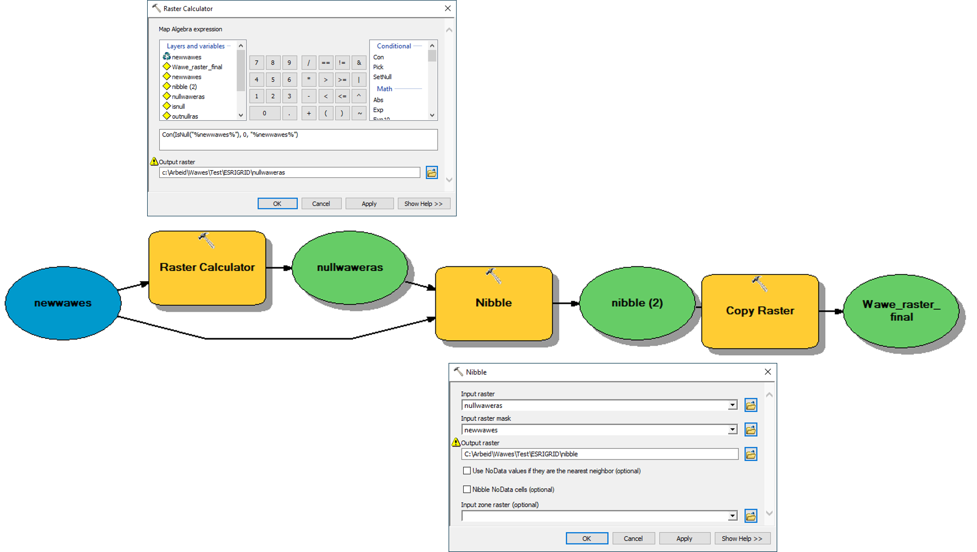
- Mark as New
- Bookmark
- Subscribe
- Mute
- Subscribe to RSS Feed
- Permalink
- Report Inappropriate Content
- « Previous
-
- 1
- 2
- Next »
- « Previous
-
- 1
- 2
- Next »