- Home
- :
- All Communities
- :
- Products
- :
- ArcGIS Spatial Analyst
- :
- ArcGIS Spatial Analyst Questions
- :
- Re: DEM values/DEM differencing
- Subscribe to RSS Feed
- Mark Topic as New
- Mark Topic as Read
- Float this Topic for Current User
- Bookmark
- Subscribe
- Mute
- Printer Friendly Page
DEM values/DEM differencing
- Mark as New
- Bookmark
- Subscribe
- Mute
- Subscribe to RSS Feed
- Permalink
- Report Inappropriate Content
Hi everyone,
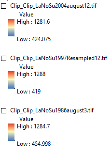
I would like to compare the elevation and volume of three DEMs. When I export the original DEMs in TIFF format the elevation values change. I do not use compression or any other kind of data transformation. It makes me wonder what the real elevation values are.
Before
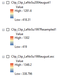
After
My second question is that I have calculated the volume difference of my DEMs (not the TIFF versions but the original) and it says that there is an increase in total volume between the DEMs. It is nearly impossible, since these are glacier surfaces that are known to decline in this area (and in most parts of the World). It is unlikely that there is a snow bias and my DEMs are in the same coordinate system and all clipped to the same vector shape.
Any idea what could have gone wrong?
Thanks
Laz
- Mark as New
- Bookmark
- Subscribe
- Mute
- Subscribe to RSS Feed
- Permalink
- Report Inappropriate Content
was the raster defined correctly to begin with?
spaces and other stuff in the output paths
type of raster? ie esri grid, tif??
output coordinate system?
cell size?
extent?
the errors are always in the details... all the details
- Mark as New
- Bookmark
- Subscribe
- Mute
- Subscribe to RSS Feed
- Permalink
- Report Inappropriate Content
Very true. I double check the above. Thanks.
- Mark as New
- Bookmark
- Subscribe
- Mute
- Subscribe to RSS Feed
- Permalink
- Report Inappropriate Content
Apparently, my contour map can only be projected in WGS 84 UTM Zone 27N. WGS 84 projection is not working.
Other than that, my three DEMs were in different formats and spatial resolution. I resampled them, but changing formats result in different elevation values. It is very important to have them right since I am looking at volumetric differences of glaciers through geodetic mass balance method. According to the volume calculations using 'Surface volume' tool, my 2004 DEM shows an increase in volume compared to the 1986DEM. It is unlikely that the glacier has grown since, as ice is known to be retreating rapidly in that region. It bugs me that when changing formats and/or pixel type the elevation values and volue changes. It makes me wonder what the actual elevation values are for my DEMS.
- Mark as New
- Bookmark
- Subscribe
- Mute
- Subscribe to RSS Feed
- Permalink
- Report Inappropriate Content
if the glacier area was collected with a GCS with elevations in meters, the GCS data can be projected with an appropriate planar cell size. Geographic coordinates are pretty well only useful for recording location. Calculating area and/or volume, (even using the best algorithms), are difficult at best. Projection of the area to planar coordinates at least gives you a known representation error. Suggestions would be to include some data samples and at least what cell size and extent you used during the projection from GCS to projected data.
- Mark as New
- Bookmark
- Subscribe
- Mute
- Subscribe to RSS Feed
- Permalink
- Report Inappropriate Content
This sounds way too complicated. Almost makes it impossible to align DEMs. I started to question the precision of every DEM I ecer used.thanks for your help Dan
- Mark as New
- Bookmark
- Subscribe
- Mute
- Subscribe to RSS Feed
- Permalink
- Report Inappropriate Content
I will change it to a discussion since there appears to be no resolution that has worked.
- « Previous
-
- 1
- 2
- Next »
- « Previous
-
- 1
- 2
- Next »