- Home
- :
- All Communities
- :
- Products
- :
- ArcGIS Spatial Analyst
- :
- ArcGIS Spatial Analyst Questions
- :
- Output raster from geostatistical layer to match t...
- Subscribe to RSS Feed
- Mark Topic as New
- Mark Topic as Read
- Float this Topic for Current User
- Bookmark
- Subscribe
- Mute
- Printer Friendly Page
Output raster from geostatistical layer to match template raster: why is there an extra row of NoData cells?
- Mark as New
- Bookmark
- Subscribe
- Mute
- Subscribe to RSS Feed
- Permalink
- Report Inappropriate Content
I have a geostatistical layer created using ordinary kriging and the 'Create Geostatistical Layer' tool in Model Builder. I am trying to output this layer to a raster that matches a target raster using the 'GA Layer to Grid' tool. I have used the target raster to set the 'Snap Raster', 'Cell Size', and 'Processing Extent' environment variables and various logical combinations of these variables. However, the raster that is output has one additional row at the top when compared to the target raster. This row is filled with NoData values.
The target raster has these dimensions:
Columns_and_Rows: 110, 166
Cell_Size: 0.11559105, 0.11559105
Extent:
Top 49.359975678
Left -129.652945807
Right -116.937930333
Bottom 30.1718614184
Spatial_Reference: CS_WGS_1984
The output raster has these:
Columns_and_Rows: 110, 167
Cell_Size: 0.11559105, 0.11559105
Extent:
Top 49.4755667278
Left -129.652945807
Right -116.937930333
Bottom 30.1718614184
Spatial_Reference: CS_WGS_1984
Why does my raster have an extra row (and therefore the wrong Extent) and how can I fix this?
Solved! Go to Solution.
Accepted Solutions
- Mark as New
- Bookmark
- Subscribe
- Mute
- Subscribe to RSS Feed
- Permalink
- Report Inappropriate Content
I was able to resolve my problem by setting additional variables both for the environment and the tool. Specifically, I added the target raster as an element in the model. I then used the 'Connect' tool to link it to the 'GA Layer to Grid' model object and set: 1) Snap raster environment variable, 2) Extent environment variable, 3) Cell size tool parameter and 4) Cell size environment variable. I don't know if the order has any effect (it shouldn't), but this process gave me output rasters with the proper resolution and extent matching the target raster.
- Mark as New
- Bookmark
- Subscribe
- Mute
- Subscribe to RSS Feed
- Permalink
- Report Inappropriate Content
Robert
It appears that you are using unprojected data. In other words, your data are in degrees decimal. One degree latitude is not equal to one degree longitude.
Only one interpolation tool in ArcGIS can work with these data, viz., Empirical Bayesian Kriging.
For more on this also see Distance calculations for data in geographic coordinates.
Alternatively, projected your data prior to interpolation.
Regards
-Steve
- Mark as New
- Bookmark
- Subscribe
- Mute
- Subscribe to RSS Feed
- Permalink
- Report Inappropriate Content
Thanks for the comment, Steve. I have ultimately switched to using EBK, so the projection issue is not a problem. I have another question, however. I would like to export the CrossValidation result table for each surface created in my Model Builder model to use for further assessing the resulting surface. Do you know of a way to automate export of this table in Model Builder?
- Mark as New
- Bookmark
- Subscribe
- Mute
- Subscribe to RSS Feed
- Permalink
- Report Inappropriate Content

- Mark as New
- Bookmark
- Subscribe
- Mute
- Subscribe to RSS Feed
- Permalink
- Report Inappropriate Content
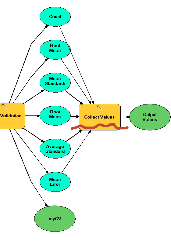
Hi Steve. Thanks for the hint!... that was helpful. The Cross Validation GA utility tool seems to provide the summary statistics as values and the option to append the point CV to a point feature layer. Since I will be iterating over my input points and selecting subsets, it seems that exporting to the input points feature layer is not possible.
I would like to 1) Store the summary CV statistics for each iteration in a table or other output and 2) save the table of CV statistics per point.
Are these tasks beyond Model Builder? If not, can you steer me toward how I can do them?
- Mark as New
- Bookmark
- Subscribe
- Mute
- Subscribe to RSS Feed
- Permalink
- Report Inappropriate Content
Sorry, I now see that I can just export each CV point table as part of a new feature layer for each iteration. Is there a way to combine all of the summary CV statistics into a table or other format?
- Mark as New
- Bookmark
- Subscribe
- Mute
- Subscribe to RSS Feed
- Permalink
- Report Inappropriate Content
Python script would be the most flexible route, however, in Modelbuilder