- Home
- :
- All Communities
- :
- Products
- :
- ArcGIS Viewer for Flex (Retired)
- :
- ArcGIS Viewer for Flex Questions
- :
- Custom eLocate Widget
- Subscribe to RSS Feed
- Mark Topic as New
- Mark Topic as Read
- Float this Topic for Current User
- Bookmark
- Subscribe
- Mute
- Printer Friendly Page
- Mark as New
- Bookmark
- Subscribe
- Mute
- Subscribe to RSS Feed
- Permalink
- Report Inappropriate Content
When I was hired part of my hiring meant I adopted some old Flex maps. I've been trying to get WAB versions created but "work."
So... I have one map. It's internal so I can only show screen shots. But our 911 people use it. It has one "custom" widget that I can't find documentation on ANYWHERE. I'm hoping that if I show some screen shots and some of the config.xml for it I can trigger someone to say, "Yeah! I know that one. I can help you!" (and while I'm wishing on a star let's throw in a bucket of money too)
Anyway... here is the XML configuration for it...
<?xml version="1.0" ?>
<configuration>
<locator>http://geocode.arcgis.com/arcgis/rest/services/World/GeocodeServer</locator>
<keepinspectoractive>true</keepinspectoractive>
<usesearchextent>true</usesearchextent>
<minscore>40</minscore>
<zoomscale>10000</zoomscale>
<pointunits>
<pointunit abbr="wgs84dms" example="85-50-1.45 W, 33-39-10.99 N" wkid="4326" xlabel="Longitude:" ylabel="Latitude:">DMS (WGS84)</pointunit>
<pointunit abbr="map" example="-9555431.36, 3982180.11" wkid="102100" xlabel="Easting (X):" ylabel="Northing (Y):">Map</pointunit>
<pointunit abbr="spal" example="656036.27, 1147053.29" wkid="102629" xlabel="Easting (X):" ylabel="Northing (Y):">NAD83 AL East (SP Feet)</pointunit>
<pointunit abbr="wgs84dd" example="-85.8337, 33.6531" wkid="4326" xlabel="Longitude:" ylabel="Latitude:">Decimal Degrees (WGS84)</pointunit>
<pointunit abbr="wgs84dm" example="85-50 W, 33-39 N" wkid="4326" xlabel="Longitude:" ylabel="Latitude:">DM (WGS84)</pointunit>
<pointunit abbr="utm16n" example="608140.63, 3724298.41" wkid="26916" xlabel="X:" ylabel="Y:">NAD 1983 UTM 16N</pointunit>
</pointunits>
<labels>
<descriptionlabel>Use the inspect address tool to click on the map and locate the address:</descriptionlabel>
</labels>
<symbols>
<geopicturemarkersymbol url="widgets/eLocate/assets/images/i_house.png" height="30" width="30" xoffset="0" yoffset="0" angle="0"/>
<coordpicturemarkersymbol url="assets/images/i_pin.png" height="30" width="30" xoffset="0" yoffset="0" angle="0"/>
</symbols>
<initialview>coordinates</initialview>
</configuration>
and the screenshot for it is here...
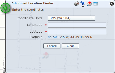
If I can find a WAB version of this then I think it might be easier to recreate this map in WAB with this widget. Which is basically all they use this map for, to find a location based on a series of coordinate systems.
Anyone have an idea?
Solved! Go to Solution.
Accepted Solutions
- Mark as New
- Bookmark
- Subscribe
- Mute
- Subscribe to RSS Feed
- Permalink
- Report Inappropriate Content
Brian, I wonder if Tim Witt 's Location Widget will work for you.
Link to the demo site I have in my resource (not sure if it is for current version or not)
But Tim would be able to give more details.
- Mark as New
- Bookmark
- Subscribe
- Mute
- Subscribe to RSS Feed
- Permalink
- Report Inappropriate Content
Brain,
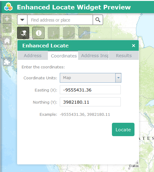
It looks like you are talking about the eLocate widget here http://www.arcgis.com/home/item.html?id=e147c73451bb4c93b1cf150f4f316775
I have not ported it to WAB yet but it is one the list to do.
- Mark as New
- Bookmark
- Subscribe
- Mute
- Subscribe to RSS Feed
- Permalink
- Report Inappropriate Content
Robert, given that Tim and Thomas Colson ( Customization of Tim W's location widget: 1.1 ) already have widgets started and working, would you still port yours over? If you haven't looked at these, might be worth it. I know that Tim's widget demo even seems to work with different projects....but I haven't tried it with my setup yet....which starts in a different project.
Personally, I would like to see one really solid widget than (with configuration options) than three almost the same. Just my opinion, and I'm very happy with all the effort you and the rest contribute.
- Mark as New
- Bookmark
- Subscribe
- Mute
- Subscribe to RSS Feed
- Permalink
- Report Inappropriate Content
Rebecca,
Tims widget only does locations of coordinates with reverse geocode. My eLocate from flex does Address locations, Reverse geocodeing, and locations by coordinates. So Yes I will probably still port mine over.
- Mark as New
- Bookmark
- Subscribe
- Mute
- Subscribe to RSS Feed
- Permalink
- Report Inappropriate Content
Ahh yes, I didn't catch that. Looking forward to any widgets you produce. I did use you eLocate in our flex app.....we just have so many locations that don't have addresses that I didn't use that part as much. Keep up the great work you do!
- Mark as New
- Bookmark
- Subscribe
- Mute
- Subscribe to RSS Feed
- Permalink
- Report Inappropriate Content
Brain,
I am done developing the widgets functionality. Now I just have to develop the widget config UI (no small task) and create the help documentation. Just to let you know it is coming soon.
- Mark as New
- Bookmark
- Subscribe
- Mute
- Subscribe to RSS Feed
- Permalink
- Report Inappropriate Content