Turn on suggestions
Auto-suggest helps you quickly narrow down your search results by suggesting possible matches as you type.
Cancel
- Home
- :
- All Communities
- :
- Products
- :
- ArcPad
- :
- ArcPad Questions
- :
- Accuracy issue in capturing XYZ points with ArcPad...
Options
- Subscribe to RSS Feed
- Mark Topic as New
- Mark Topic as Read
- Float this Topic for Current User
- Bookmark
- Subscribe
- Mute
- Printer Friendly Page
Accuracy issue in capturing XYZ points with ArcPad installed in Leica CS25,
Subscribe
3934
14
11-25-2013 08:38 AM
11-25-2013
08:38 AM
- Mark as New
- Bookmark
- Subscribe
- Mute
- Subscribe to RSS Feed
- Permalink
- Report Inappropriate Content
Accuracy issue in capturing XYZ points with ArcPad installed in Leica CS25,
I tried to capture the XYZ of a known point with our GPS device (Leica CS25 + GG03 Antenna) but the sounds that the captured point is not accurate knowing that this point is real-time differentially corrected. The error is X is about 6 meters while the error in Y is about 8 meters.
The coordinate system is set to be ???D-Palestine-1923???
What might be the issue here?
Thank you
Best
Jamal
----------------------------------------
Jamal Numan
Geomolg Geoportal for Spatial Information
Ramallah, West Bank, Palestine
Jamal Numan
Geomolg Geoportal for Spatial Information
Ramallah, West Bank, Palestine
14 Replies
11-25-2013
09:58 AM
- Mark as New
- Bookmark
- Subscribe
- Mute
- Subscribe to RSS Feed
- Permalink
- Report Inappropriate Content
If you are using Zeno Connect, do you have a transformation applied that should not be or are you not applying a transformation and should be?
11-25-2013
10:11 AM
- Mark as New
- Bookmark
- Subscribe
- Mute
- Subscribe to RSS Feed
- Permalink
- Report Inappropriate Content
If you are using Zeno Connect, do you have a transformation applied that should not be or are you not applying a transformation and should be?
Many thanks Brett for the help,
I didn�??t apply any kind of transformation.
The screenshots below shows the coordinates of the known point and the ones I captured by the CS25
[ATTACH=CONFIG]29333[/ATTACH], [ATTACH=CONFIG]29334[/ATTACH]
How to know that I need to apply a particular transformation? If the transformation is required, then how to apply it?
----------------------------------------
Jamal Numan
Geomolg Geoportal for Spatial Information
Ramallah, West Bank, Palestine
Jamal Numan
Geomolg Geoportal for Spatial Information
Ramallah, West Bank, Palestine
11-25-2013
12:22 PM
- Mark as New
- Bookmark
- Subscribe
- Mute
- Subscribe to RSS Feed
- Permalink
- Report Inappropriate Content
What's the source of these written coordinates against which you compare your own coordinates? And when were these measured?
I am not entirely sure, but I don't think a projection issue is the most likely, as any of the other common coordinate systems in your area would put you off by far more than this (up to a 1000 km due to different False Northings).
You seem to be using Palestine 1923 / Palestine Grid, other potential logical options in your area are Palestine 1923 / Palestine Belt, Palestine 1923 / Israel CS and Israel TM, but all of these aren't close in terms of FE and FN.
11-25-2013
12:34 PM
- Mark as New
- Bookmark
- Subscribe
- Mute
- Subscribe to RSS Feed
- Permalink
- Report Inappropriate Content
In Zeno Connect you are able to select your coordinate system as well as any necessary transformation based on your corrections. I do not know specifically which transformation you may need to apply, but I would recommend talking with the real-time network provider or someone familiar with GIS/GNSS field collection in the area to help you work through this issue. I am fairly certain it is a transformation issue, but you will need to either test further by selecting the various transformations available or speak with someone that can further assist.
11-26-2013
07:30 AM
- Mark as New
- Bookmark
- Subscribe
- Mute
- Subscribe to RSS Feed
- Permalink
- Report Inappropriate Content
In Zeno Connect you are able to select your coordinate system as well as any necessary transformation based on your corrections. I do not know specifically which transformation you may need to apply, but I would recommend talking with the real-time network provider or someone familiar with GIS/GNSS field collection in the area to help you work through this issue. I am fairly certain it is a transformation issue, but you will need to either test further by selecting the various transformations available or speak with someone that can further assist.
I couldn�??t get sufficient technical support from the reseller of the CS25 device in Palestine and this is why I�??m still struggling with multiple issues.
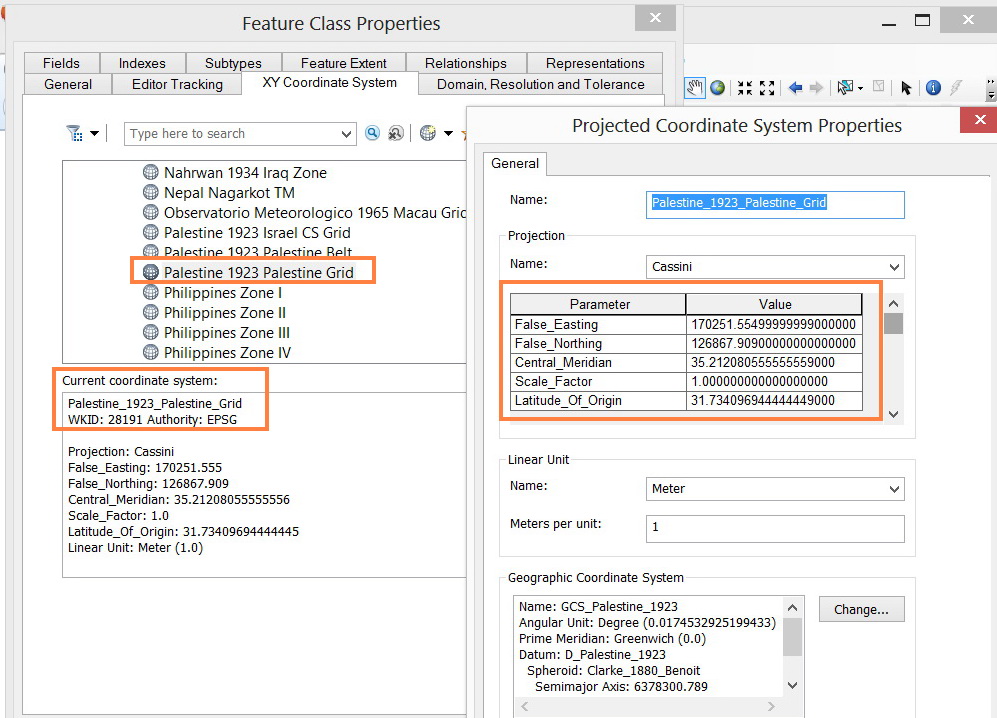
The official coordinate system in Palestine is �??Palestine_1923_Palestine_Grid�?� (but not Palestine_1923_Palestine_Belt or Palestine_1923_Israel_CS_Grid). The point that is shown in the screenshot is measured in this coordinate system (Palestine_1923_Palestine_Grid) and is considered as reference. It is for sure correct.
In case that I need to play with the parameters of our projected coordinate system (Palestine_1923_Palestine_Grid) to obtain accurate XYZ coordinates using our GPS device (CS25 + GG03 Antenna), then
1. What new values for the parameters of �??Palestine_1923_Palestine_Grid�?� the should I consider?
[ATTACH=CONFIG]29370[/ATTACH]
2. Is this implemented in ArcPad or ArcMap?
[ATTACH=CONFIG]29371[/ATTACH]
3. How the transformation is involved in this issue?
[ATTACH=CONFIG]29372[/ATTACH]
All what I wanted is to capture accurate XYZ points with our CS25 device in �??Palestine_1923_Palestine_Grid�?�.
----------------------------------------
Jamal Numan
Geomolg Geoportal for Spatial Information
Ramallah, West Bank, Palestine
Jamal Numan
Geomolg Geoportal for Spatial Information
Ramallah, West Bank, Palestine
11-26-2013
07:47 AM
- Mark as New
- Bookmark
- Subscribe
- Mute
- Subscribe to RSS Feed
- Permalink
- Report Inappropriate Content
The point that is shown in the screenshot is measured in this coordinate system (Palestine_1923_Palestine_Grid) and is considered as reference. It is for sure correct.
Jamal, although I don't necessarily want to question the quality of the reference, you should always be very critical of both your own, and other's measurements. Even top-notch government organizations here in the Netherlands, who should know better and have checks in place, have had data delivered and initially accepted that ultimately turned out to contain unacceptable positional errors when matched up against later data deliveries from other companies.
It is far better, in case of inconsistencies like these you experience now, to assume all measurements could be wrong, until proven right... It is just to easy to make some vital mistake when dealing with surveying, coordinate systems and transformations, as there are many aspects to take into account, just see the articles by Eric Gakstatter I referenced in the "Nightmare in GIS Street" thread for some nice illustrative examples.
I know it is not very helpful to you at this point in time, but that is my opinion.
11-26-2013
09:52 AM
- Mark as New
- Bookmark
- Subscribe
- Mute
- Subscribe to RSS Feed
- Permalink
- Report Inappropriate Content
Jamal,
If you are to be using Palestine_1923_Palestine_Grid and you know for certain that your control points are in the same coordinate system, then there is no need to modify anything related to the parameters of your projection files.
I said Zeno Connect allows you to setup your coordinate system as well as an associated transformation based on your corrections. Is your Leica representative also the owner of the real-time network you are receiving RTK corrections? They should be able to tell you what coordinate system the real-time network is referencing regardless of which software you are using for field collection.
11-26-2013
11:07 AM
- Mark as New
- Bookmark
- Subscribe
- Mute
- Subscribe to RSS Feed
- Permalink
- Report Inappropriate Content
Jamal,
If you are to be using Palestine_1923_Palestine_Grid and you know for certain that your control points are in the same coordinate system, then there is no need to modify anything related to the parameters of your projection files.
X2.
Good points Brett, I agree there shouldn't be need to modify projection details. Custom projections are only necessary in very rare cases, and this isn't one of them. There may be an issue with transformations, as you justly pointed out and I also suspect.
I said Zeno Connect allows you to setup your coordinate system as well as an associated transformation based on your corrections. Is your Leica representative also the owner of the real-time network you are receiving RTK corrections? They should be able to tell you what coordinate system the real-time network is referencing regardless of which software you are using for field collection.
The RTK may be in Israel TM grid, as that is the current CRS (coordinate reference system) for Israel. Jamal may have more info.
11-26-2013
01:09 PM
- Mark as New
- Bookmark
- Subscribe
- Mute
- Subscribe to RSS Feed
- Permalink
- Report Inappropriate Content
X2.
Good points Brett, I agree there shouldn't be need to modify projection details. Custom projections are only necessary in very rare cases, and this isn't one of them. There may be an issue with transformations, as you justly pointed out and I also suspect.
The RTK may be in Israel TM grid, as that is the current CRS (coordinate reference system) for Israel. Jamal may have more info.
Thank you Macro.
That might be correct. The reseller in Palestine is probably connected to the RTK of an Israeli company called etkes. I have sent them an e-mail and I�??m waiting there answer.
At the same time, I don�??t think that the RTK is based on the Israeli grid as the difference between the Israli TM and Palestine Grid 1923 is 50,000 in X and 500,000 in Y. For example, the (160000, 170000) in Palestine Grid is equivalent to (210000, 670000) in Israli TM
The captured XYZ coordinates at the �??control point�?� is only few meters away from the precise one (as it shown in the previous screenshot)
----------------------------------------
Jamal Numan
Geomolg Geoportal for Spatial Information
Ramallah, West Bank, Palestine
Jamal Numan
Geomolg Geoportal for Spatial Information
Ramallah, West Bank, Palestine