- Home
- :
- All Communities
- :
- User Groups
- :
- Coordinate Reference Systems
- :
- Questions
- :
- Re: Confirming whether ArcGIS Pro is doing a Horiz...
- Subscribe to RSS Feed
- Mark Topic as New
- Mark Topic as Read
- Float this Topic for Current User
- Bookmark
- Subscribe
- Mute
- Printer Friendly Page
Confirming whether ArcGIS Pro is doing a Horizontal AND Vertical datum transformation between ITRF00 and ITRF08 for raster?
- Mark as New
- Bookmark
- Subscribe
- Mute
- Subscribe to RSS Feed
- Permalink
- Report Inappropriate Content
Hello-
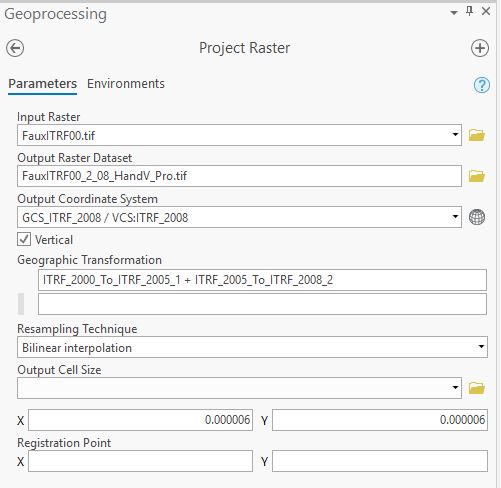
I am using ArcGIS Pro v 2.3.2 and am trying to project raster DEMs with a HCS and VCS in ITRF00 to ITRF08.
The Geographic Transformation method chosen is ITRF_2000_To_ITRF_2005_1 + ITRF_2005_To_ITRF_2008_2.
A screenshot of the what I entered in the Project Raster tool is below.
Can someone confirm that both the horizontal and vertical values in the output raster will be transformed to ITRF2008?
I am looking for verification that the Z values (ellipsoid heights) are actually being transformed.
- Mark as New
- Bookmark
- Subscribe
- Mute
- Subscribe to RSS Feed
- Permalink
- Report Inappropriate Content
I can confirm what is says in the help
Project Raster—Data Management toolbox | ArcGIS Desktop
To perform a vertical transformation, check the optional Vertical parameter on the dialog box. By default, the Vertical parameter is unavailable and is only available when the input and output coordinate systems have a vertical coordinate system (VCS), and the input feature class coordinates have z-values. Also, additional data (coordinate systems data) setup needs to be installed on the system
- Mark as New
- Bookmark
- Subscribe
- Mute
- Subscribe to RSS Feed
- Permalink
- Report Inappropriate Content
Both transformations, ITRF_2000_To_ITRF_2005_1 and ITRF_2005_To_ITRF_2008_2, are not null, Position Vector transformations with parameters. You can check them here: https://desktop.arcgis.com/en/arcmap/latest/map/projections/pdf/geographic_transformations.pdf
As Dan Patterson already replied, you need to check the optional Vertical parameter, which you did. If your input heights were ellipsoidal, then your output should be ellipsoidal heights in ITRF 2008 withing the accuracy of the used transformations.
I hope this helps.
- Mark as New
- Bookmark
- Subscribe
- Mute
- Subscribe to RSS Feed
- Permalink
- Report Inappropriate Content
Thank you Bojan and Dan. Yes, I had already checked the help and the transformations pdf and noticed the transformation parameters were correct (and not null). But that doesn't mean that behind the scenes the software is actually applying the vertical transformation portion. In ArcMap, for example, the same transformation (ITRF_2000_To_ITRF_2005_1 and ITRF_2005_To_ITRF_2008_2) can be applied to a raster DEM with a defined HCS & VCS, but in reality (b/c ArcMap will only do vertical transformations on vector data, but not on rasters), only the horizontal coordinates are transformed and nothing is applied to the vertical. Out of an abundance of caution I was looking for confirmation that in Project Raster the VCS transformation from ITRF00 to ITRF08 is truly being applied in ArcGIS Pro 2.3.2 (without having to install any separate Coordinate Systems Data file), as this is an important part of the workflow for one of our projects.
On a second note, I just noticed in the Project Raster help that "This tool can only output a square cell size." Our data is in Geographic/decimal degrees, ITRF00 and is being transformed to Geographic ITRF08. The pixel size is 0.000006 x 0.000006 degrees (i.e., same dimensions in x & y), but in a linear sense the size is a rectangle, not square. So now I am confused. Can I even use Project Raster when working in a geographic coordinate system?? Help!
- Mark as New
- Bookmark
- Subscribe
- Mute
- Subscribe to RSS Feed
- Permalink
- Report Inappropriate Content
Ok...feeling a little silly about my paranoia. From everything in the help it sounds like Project Raster in ArcGIS Pro should be applying both the HCS AND the VCS transformations between ITRF00 and ITRF08; however if someone knows differently please correct me. I'm still confused about "this tool can only output a square cell size" though, when coordinates are in degrees...
- Mark as New
- Bookmark
- Subscribe
- Mute
- Subscribe to RSS Feed
- Permalink
- Report Inappropriate Content
the cell is square in spherical coordinates.
If you want planar coordinates, then you should project the data... but... read this
How the Cell Size Projection Method environment setting works—Geoprocessing | ArcGIS Desktop
It was added in Pro 2.4 and is worth the read, especially if you want to use the data for anything that requires planar measures