- Home
- :
- All Communities
- :
- User Groups
- :
- Coordinate Reference Systems
- :
- Questions
- :
- Re: GRS 80 to WGS84
- Subscribe to RSS Feed
- Mark Topic as New
- Mark Topic as Read
- Float this Topic for Current User
- Bookmark
- Subscribe
- Mute
- Printer Friendly Page
- Mark as New
- Bookmark
- Subscribe
- Mute
- Subscribe to RSS Feed
- Permalink
- Report Inappropriate Content
I have few thousand rasters in AK zone 4 state plane on NAD83 and in UTM5/6 on GRS 80 that I am trying to mosaic into Web Mercator. Arc is reporting that I need a transformation but I do not see an esri transformation for it. I understand that the ellipsoids are almost the same. NOAA/NOS's VDatum: A tutorial on datums
What is the recommendation for dealing with this?
Solved! Go to Solution.
Accepted Solutions
- Mark as New
- Bookmark
- Subscribe
- Mute
- Subscribe to RSS Feed
- Permalink
- Report Inappropriate Content
I thought I answered this elsewhere, but maybe it was someone else asking?
GRS80 is an ellipsoid/spheroid, not a true geodetic datum / geographic coordinate system. If that's all that is listed (particularly for GRIDs or coverages), the software will create a "GRS80-based" geographic coordinate system. Because it's not a true GCS, we have no transformations to or from GRS80. It's more likely that the data is on NAD83 or one of its realizations.
If the raster's cell size is larger than a meter or so, you could redefine them directly as WGS84 UTM zone X and then project them to Web Mercator.
Or redefine the GCS portion as NAD 1983 (name may be "GCS_North_American_1983").
Or if you know that they're really on a different realization of NAD83, like NAD 1983 (2011), redefine the GCS as that.
Or use the create custom geographic transformation tool. You'll need the exact GCS definition from the raster. If there's no need to transform (you can treat NAD83 and WGS84 as equivalent (cell size > 1-2 meters)), use the null transformation method or the geocentric translation (leave the parameter values as zeroes).
If the cell size is smaller, try to do some research on what NAD83 realization was used to georeference these images. WIth that information, I can suggest what transformation to use.
Melita
- Mark as New
- Bookmark
- Subscribe
- Mute
- Subscribe to RSS Feed
- Permalink
- Report Inappropriate Content
Anyone have any thoughts on this?
- Mark as New
- Bookmark
- Subscribe
- Mute
- Subscribe to RSS Feed
- Permalink
- Report Inappropriate Content
MKennedy-esristaff .... this one is for you
- Mark as New
- Bookmark
- Subscribe
- Mute
- Subscribe to RSS Feed
- Permalink
- Report Inappropriate Content
I thought I answered this elsewhere, but maybe it was someone else asking?
GRS80 is an ellipsoid/spheroid, not a true geodetic datum / geographic coordinate system. If that's all that is listed (particularly for GRIDs or coverages), the software will create a "GRS80-based" geographic coordinate system. Because it's not a true GCS, we have no transformations to or from GRS80. It's more likely that the data is on NAD83 or one of its realizations.
If the raster's cell size is larger than a meter or so, you could redefine them directly as WGS84 UTM zone X and then project them to Web Mercator.
Or redefine the GCS portion as NAD 1983 (name may be "GCS_North_American_1983").
Or if you know that they're really on a different realization of NAD83, like NAD 1983 (2011), redefine the GCS as that.
Or use the create custom geographic transformation tool. You'll need the exact GCS definition from the raster. If there's no need to transform (you can treat NAD83 and WGS84 as equivalent (cell size > 1-2 meters)), use the null transformation method or the geocentric translation (leave the parameter values as zeroes).
If the cell size is smaller, try to do some research on what NAD83 realization was used to georeference these images. WIth that information, I can suggest what transformation to use.
Melita
- Mark as New
- Bookmark
- Subscribe
- Mute
- Subscribe to RSS Feed
- Permalink
- Report Inappropriate Content
Sorry Melita, looks like you may have responded to the same question on a different forum (I did wait a few day before I created a second post). I should have closed this one. However...
I am still a little bothered by this. I don't get why anyone would collect elevation data on a nonexistent datum over a large area. Have you seen this problem before? I guess some technician could have messed up someplace in the processing.
The project has been passed around a little -- so, contacting the original vendor for the data may be difficult.
Also, I was concerned when I read the Wikipedia page for GRS80 (I know it could be wrong).
"GRS 80, or Geodetic Reference System 1980, is a geodetic reference system consisting of a global reference ellipsoid and a gravity field model."
I was thinking that a geodetic reference system went beyond just an ellipsoid to include a coordinate system. They also talk about a gravity field model, which makes me think geoid. If it is just an ellipsoid it can not have a geoid as well.... All adding to my confusion. Can you please provide me with a definition of "geodetic reference system"?
Thanks!
Forest
- Mark as New
- Bookmark
- Subscribe
- Mute
- Subscribe to RSS Feed
- Permalink
- Report Inappropriate Content
Here are a couple of links that may be useful....
- Mark as New
- Bookmark
- Subscribe
- Mute
- Subscribe to RSS Feed
- Permalink
- Report Inappropriate Content
It could be as simple as the data had the correct gcs/datum at one point when passed through a software package or was reprojected where that gcs/datum isn't supported. The software kept what it could (the ellipsoid) but lost the rest of the information.
The GRS80 page isn't wrong, but no one "realizes" an actual geodetic coordinate system as grs80 directly. The closest is ITRFxx by the IERS who insist that the ITRFxx (international terrestrial reference frame, xx = year) has no ellipsoid at all, although they'll say to use GRS80 if you convert from the "native" XYZ coordinates into latitude-longitude-ellipsoidal height values. Next closest would be the US military's WGS84 but you'll notice that they don't call it GRS80. I, personally, would think of GRS80 as more of a theoretical surface. WGS84, ITRFxx, etc. "realize" by tying it to coordinate points on the ground, as it were.
- Mark as New
- Bookmark
- Subscribe
- Mute
- Subscribe to RSS Feed
- Permalink
- Report Inappropriate Content
Thanks, Melita for all the feedback. It is appreciated. The intermediate software makes sense. But I still think it is very sloppy.
Thanks for the context on GRS80.
- Mark as New
- Bookmark
- Subscribe
- Mute
- Subscribe to RSS Feed
- Permalink
- Report Inappropriate Content
The shift from WGS84(G1150) to NAD83(CORS96) is about 4ft in Alaska. So, it could be significant depending on the resolution of that data, as Melita pointed out.

- Mark as New
- Bookmark
- Subscribe
- Mute
- Subscribe to RSS Feed
- Permalink
- Report Inappropriate Content
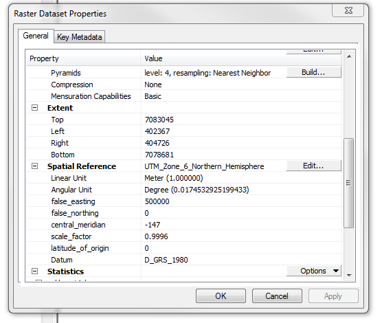
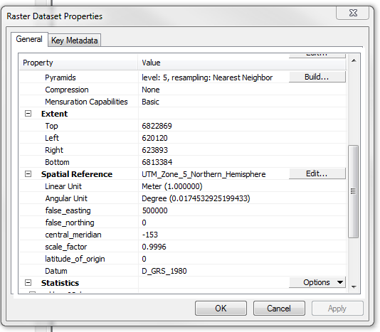
Melita I just noticed this in the projection tool help.

An additional example of the improper use of the GRS80?