- Home
- :
- All Communities
- :
- User Groups
- :
- Coordinate Reference Systems
- :
- Questions
- :
- Re: Information on the Coordinate Systems desktop ...
- Subscribe to RSS Feed
- Mark Topic as New
- Mark Topic as Read
- Float this Topic for Current User
- Bookmark
- Subscribe
- Mute
- Printer Friendly Page
Information on the Coordinate Systems desktop install?
- Mark as New
- Bookmark
- Subscribe
- Mute
- Subscribe to RSS Feed
- Permalink
- Report Inappropriate Content
Looking for more information about the optional install of coordinate systems. The What's new document for Desktop 10.5 document says this:
ArcGIS Coordinate Systems Data—Contains the data files required for the GEOCON transformation method and vertical transformation files for the United States (VERTCON and GEOID12B) and the world (EGM2008).
but I'm not seeing any discussion in the help documents for 10.5. I'm thinking some of our users may have need for this but I am having trouble finding more information. Is there an article, blog post, Esri UC session, or anything like that available that I can point my users to?
- Mark as New
- Bookmark
- Subscribe
- Mute
- Subscribe to RSS Feed
- Permalink
- Report Inappropriate Content
besides this thread https://community.esri.com/thread/171124
perhaps MKennedy-esristaff might has some links
- Mark as New
- Bookmark
- Subscribe
- Mute
- Subscribe to RSS Feed
- Permalink
- Report Inappropriate Content
I agree, the online documentation is rather sparse. That said, there isn't much to ArcGIS Coordinate Systems Data. In the thread referenced by Dan, Melita states that they pulled out these coordinate system data files because of their size. The Select Features installation screen gives an idea of just how big. I single world geoid model file is nearly 900 MB installed on disk.

- Mark as New
- Bookmark
- Subscribe
- Mute
- Subscribe to RSS Feed
- Permalink
- Report Inappropriate Content
I didn't get my act together to get a longer topic into the help for ArcGIS Desktop/Server 10.5 or ArcGIS Pro 1.4. I was specifically tasked with writing a white paper/blog posts/etc. about it. Maybe this week, while it's quiet!
Particularly for ArcGIS Pro, we're trying to keep the core setup as small as possible. Adding even the 2.5'x2.5' EGM2008 and the GEOCON files is close to 0.5 GB. Management said NO. We had discussed making a separate data install years ago, when the ArcGIS Desktop install was creeping towards requiring either another CD or maybe a DVD, but managed to scrape through.
So with geoid models coming from several countries, and more grid-file-based transformations all the time, it was decided that we've start a separate setup for that data. It also allows customers to decide to not install everything if they want. At some point, we'll likely move the existing NADCON/HARN/NTv2 files from the core setups into this separate setup, but there's no timeline for that yet.
There are two versions of the data setups. One is 32-bit and used for Desktop, Server, Engine, etc. The other is 64-bit and currently used only for ArcGIS Pro. The separation has mostly to do with being able to access the 32-bit and 64-bit registries, but ArcGIS Pro is also the one most likely to get out-of-sync with the others when dealing with release schedules.
The GEOCON files are for the US and convert between the latest NAD 1983 HARN, NAD83 (NSRS2007), and NAD83 (2011). These files are from the GEOCON and GEOCON11 1.0 versions. There's a new version in beta from the NGS, that includes multiple HARN realizations (the last one is now called an FBN). While it's in beta, we haven't added support for them yet. The transformations that use these files are:
NAD_1983_HARN_To_NSRS2007_GEOCON_CONUS
NAD_1983_HARN_To_NSRS2007_GEOCON_Alaska
NAD_1983_HARN_To_NSRS2007_GEOCON_Puerto_Rico_Virgin_Islands
NAD_1983_NSRS2007_To_2011_GEOCON11_CONUS
NAD_1983_NSRS2007_To_2011_GEOCON11_Alaska
NAD_1983_NSRS2007_To_2011_GEOCON11_Puerto_Rico_Virgin_Islands
The Vertical folder contains the EGM84 and EGM2008 2.5'x2.5' files. The EGM96 file is already in the core software. The EGM2008 1'x1' has a separate entry in the setup because it's so large. We aren't using it by default because of that.
WGS_1984_To_WGS_1984_EGM2008_1x1_Height
WGS_1984_To_WGS_1984_EGM2008_2.5x2.5_Height
WGS_1984_To_EGM_1996_Geoid_1
WGS_1984_To_EGM_1996_Geoid_2 (interpolation is natural spline)
WGS_1984_To_EGM_1984_Geoid_1
WGS_1984_To_EGM_1984_Geoid_2 (interpolation is natural spline)
The Vertical folder also contains the US Geoid12b files (Alaska, Guam and Northern Marianas, Hawaii, Puerto Rico and US Virgin Islands, American Samoa, and CONUS) and the VERTCON files. We have the east, central, and west files, plus a combined one that we built in-house.
NAD_1983_2011_To_NAVD88_CONUS_GEOID12B_Height
NAD_1983_2011_To_NAVD88_Alaska_GEOID12B_Height
NAD_1983_PA11_To_NAVD88_Hawaii_GEOID12B_Height
NAD_1983_2011_To_PRVD02_GEOID12B_Height (Puerto Rico)
NAD_1983_PA11_To_ASVD02_GEOID12B_Height (American Samoa)
NAD_1983_MA11_To_GUVD04_GEOID12B_Height (Guam)
NAD_1983_2011_To_VIVD09_GEOID12B_Height (US Virgin Islands)
NAD_1983_MA11_To_NMVD03_GEOID12B_Height (Northern Marianas)
NAD_1983_To_NAVD88_CONUS_GEOID12B_Height
NAD_1983_To_NAVD88_Alaska_GEOID12B_Height
NAD_1983_To_NAVD88_Hawaii_GEOID12B_Height
NAD_1983_To_PRVD02_GEOID12B_Height (Puerto Rico)
NAD_1983_To_VIVD09_GEOID12B_Height (US Virgin Islands)
NGVD29_To_NAVD88_NAD27_3_East
NGVD29_To_NAVD88_NAD27_2_Central
NGVD29_To_NAVD88_NAD27_1_West
NGVD29_To_NAVD88_NAD27_ECW (conus grid)
NGVD29_To_NAVD88_NAD83_East
NGVD29_To_NAVD88_NAD83_Central
NGVD29_To_NAVD88_NAD83_West
NGVD29_To_NAVD88_NAD83_ECW (conus grid)
NGVD29_To_NAVD88_HARN_East
NGVD29_To_NAVD88_HARN_Central
NGVD29_To_NAVD88_HARN_West
NGVD29_To_NAVD88_HARN_ECW (conus grid)
Note: The NAD27/NAD83/HARN in the transformation name indicates the GeoCRS used to interpolate the offset values from the grid files. The VERTCON files are imprecise enough that it doesn't matter which NAD83 adjustment you use for the interpolation. However, we still need to them listed separately. We may end up adding NSRS2007 and 2011 variants in a future release.
We had a few new NTv2 grids that ended up in the new setup as well. I suggested putting them in the core software with the existing ones, but no go. For Switzerland, we added a replacement for an existing grid, CHENYX06_etrs.gsb. For the UK, we added OSTN15_NTv2.gsb and osgb36_xrail84.gsb. The latter is for the CrossRail project in the greater London area. The transformations that use these files are below:
CH1903_To_CHTRF95_1_NTv2
CH1903_To_ETRS_1989_2_NTv2
CH1903_To_WGS_1984_3_NTv2
ETRS_1989_To_OSGB_1936_OSTN15
WGS_1984_To_OSGB_1936_OSTN15
OSGB_1936_To_Xrail84_NTv2
I'm working on other countries' geoid files but redistribution rights are often an issue.
Melita
***Edited to list the transformations that use these files.
- Mark as New
- Bookmark
- Subscribe
- Mute
- Subscribe to RSS Feed
- Permalink
- Report Inappropriate Content
Melita,
I am having issues getting the coordinate systems to install properly to be able to use the Geoid12B. Is there something special I am supposed to be doing on the installer? It runs and give success, but the systems are not showing up to select for transformation. I believe in another thread you stated it uses the hvtdefaults.json to look up the transformation. Does the installer update this file to include the new transformations?
- Mark as New
- Bookmark
- Subscribe
- Mute
- Subscribe to RSS Feed
- Permalink
- Report Inappropriate Content
The json file already lists transformations whether the data is there or not. It's more likely that the particular path you need isn't in the file. It's missing quite a bit of cases. If you can post (or email me, mkennedy at esri) the source and target coordinate systems, I can check the json file for you.
Melita
- Mark as New
- Bookmark
- Subscribe
- Mute
- Subscribe to RSS Feed
- Permalink
- Report Inappropriate Content
My sources to support the idea of using ArcMap 10.4.1 are attached.

- Mark as New
- Bookmark
- Subscribe
- Mute
- Subscribe to RSS Feed
- Permalink
- Report Inappropriate Content
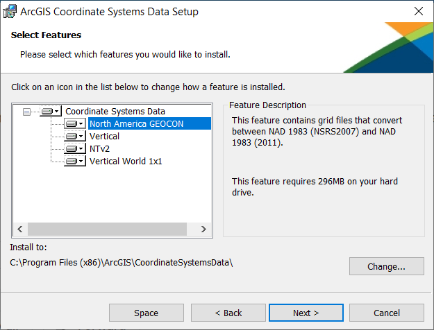
Update on this topic, here is the installer for the separate Coordinate Systems package for 10.7. (Note, no changes apparently since Joshua Bixby's screenshot above with 10.5, except maybe more data added to NTv2 for local areas?)
It seems North American GEOCON and NTv2 are horizontal transformations in North America, and the other two are for support of vertical transformations for North America and the wide world.
Melita Kennedy Did that white paper ever appear? I guess the question I have is whether we should be using NTv2 instead of NADCON if we need cm accuracy as it sounds like it is NADCON improved from the descriptions I read. Would be great to have some guidance on these new capabilities for the vast number of us geodetically unwashed. Margaret Maher I sure hope you are planning for more excellent explication in a fourth edition of my favorite Esri Press book Lining Up Data.
- Mark as New
- Bookmark
- Subscribe
- Mute
- Subscribe to RSS Feed
- Permalink
- Report Inappropriate Content
Nope. I'm just terrible about writing and haven't done it yet. But here is an update on the additions to the setup for 10.6.0 / Pro 2.1, 10.6.1 / Pro 2.2, and 10.7.0 / Pro 2.3!
GEOCON files are strictly US. We added the main NAD27 to NAD83 NTv2 for Canada. Other NTv2 files are for various countries. NTv2 is the usual file format used for geographic/datum transformations, although I've occasionally seem NADCON files used elsewhere than the US. The Vertical World 1x1 option is for the 1'x1' EGM2008 file. It's almost 1 GB by itself so has a special option to not install it. All other vertical files are in the "vertical" option. That includes geoid models and other file-based transformations for Japan, New Zealand, Switzerland, US (geoid12b), the 2.5'x2.5' EGM2008 file, and EGM84 (world).
Geographic/Datum transformations
10.7.0 / 2.3
ntv2-ch03p-etrs.gsb Switzerland CH1903+_To_CHTRF95_NTv2
CH1903+_To_ETRS_1989_NTv2
BD72LB72_ETRS89LB08 Belgium Belge_1972_To_ETRS_1989_3
10.6.1 / 2.2
GDA94_GDA2020_conformal Australia GDA_1994_To_GDA2020_NTv2_3_Conformal
GDA94_GDA2020_conformal_and_distortion Australia GDA_1994_To_GDA2020_NTv2_3_Conformal
10.6.0 / 2.1
BALR2009 Spain ED_1950_To_WGS_1984_NTv2_BALR2009
ED_1950_To_ETRS_1989_NTv2_BALR2009
PENR2009 Spain ED_1950_To_ETRS_1989_NTv2_PENR2009
ED_1950_To_WGS_1984_NTv2_PENR2009
UPDATE 20 November 2019!! I missed this Canadian file:
Ntv2_0.gsb Canada NAD_1927_To_NAD_1983_NTv2_Canada
NAD_1927_To_WGS_1984_33
Vertical
10.6.1 / 2.2
chgeo2004_ETRS Switzerland CHTRF95_To_LHN95_Height
10.6.0 / 2.1
JGEOID2008 Japan JGD_2000_To_JGD_2000_Vertical_Height_1
GSIGEOID2011 Japan JGD_2011_To_JGD_2011_Vertical_Height_1
New_Zealand_Quasigeoid_2016 New Zealand NZGD2000_To_NZGD2016_Height_1
auckland_1946_to_nzvd2016 New Zealand NZVD2016_Height_To_Auckland_1946_Height_1
bluff_1955_to_nzvd2016 New Zealand NZVD2016_Height_To_Bluff_1955_Height_1
dunedin_1958_to_nzvd2016 New Zealand NZVD2016_Height_To_Dunedin_1958_Height_1
Dunedin-Bluff_1960_to_nzvd2016 New Zealand NZVD2016_Height_To_Dunedin-Bluff_1960_Height_1
gisborne_1926_to_nzvd2016 New Zealand NZVD2016_Height_To_Gisborne_1926_Height_1
lyttelton_1937_to_nzvd2016 New Zealand NZVD2016_Height_To_Lyttelton_1937_Height_1
moturiki_1953_to_nzvd2016 New Zealand NZVD2016_Height_To_Moturiki_1953_Height_1
napier_1962_to_nzvd2016 New Zealand NZVD2016_Height_To_Napier_1962_Height_1
nelson_1955_to_nzvd2016 New Zealand NZVD2016_Height_To_Nelson_1955_Height_1
one_tree_point_1964_to_nzvd2016 New Zealand NZVD2016_Height_To_One_Tree_Point_1964_Height_1
stewart_island_1977_to_nzvd2016 New Zealand NZVD2016_Height_To_Stewart_Island_1977_Height_1
taranaki_1970_to_nzvd2016 New Zealand NZVD2016_Height_To_Taranaki_1970_Height_1
wellington_1953_to_nzvd2016 New Zealand NZVD2016_Height_To_Wellington_1953_Height_1
auckland_1946_to_nzgd2000 New Zealand Auckland_1946_Height_To_NZGD2000_Height_1
bluff_1955_to_nzgd2000 New Zealand Bluff_1955_Height_To_NZGD2000_Height_1
dunedin_1958_to_nzgd2000 New Zealand Dunedin_1958_Height_To_NZGD2000_Height_1
Dunedin-Bluff_1960_to_nzgd2000 New Zealand Dunedin-Bluff_1960_Height_To_NZGD2000_Height_1
gisborne_1926_to_nzgd2000 New Zealand Gisborne_1926_Height_To_NZGD2000_Height_1
lyttelton_1937_to_nzgd2000 New Zealand Lyttelton_1937_Height_To_NZGD2000_Height_1
moturiki_1953_to_nzgd2000 New Zealand Moturiki_1953_Height_To_NZGD2000_Height_1
napier_1962_to_nzgd2000 New Zealand Napier_1962_Height_To_NZGD2000_Height_1
nelson_1955_to_nzgd2000 New Zealand Nelson_1955_Height_To_NZGD2000_Height_1
one_tree_point_1964_to_nzgd2000 New Zealand One_Tree_Point_1964_Height_To_NZGD2000_Height_1
stewart_island_1977_to_nzgd2000 New Zealand Stewart_Island_1977_Height_To_NZGD2000_Height_1
taranaki_1970_to_nzgd2000 New Zealand Taranaki_1970_Height_To_NZGD2000_Height_1
wellington_1953_to_nzgd2000 New Zealand Wellington_1953_Height_To_NZGD2000_Height_1
UPDATE: Added Canadian NTv2 file to the 10.6.0 / Pro 2.1 entries on 20 November 2019.
- Mark as New
- Bookmark
- Subscribe
- Mute
- Subscribe to RSS Feed
- Permalink
- Report Inappropriate Content
Is there a location where this Coordinate Systems Data can be downloaded from to use in ArcGIS Pro? All links I have seen to download have pointed me to the myesri page which has no information on it about the Coordinate Systems Data. I wasn't able to find any kind of valuable answer to this on this thread or anywhere else. Is this something that should be setup during the install of Pro?
Thanks!