- Home
- :
- All Communities
- :
- User Groups
- :
- Coordinate Reference Systems
- :
- Questions
- :
- Re: Scale bar inaccurate on a projected geo-refere...
- Subscribe to RSS Feed
- Mark Topic as New
- Mark Topic as Read
- Float this Topic for Current User
- Bookmark
- Subscribe
- Mute
- Printer Friendly Page
Scale bar inaccurate on a projected geo-referenced map image, why?
- Mark as New
- Bookmark
- Subscribe
- Mute
- Subscribe to RSS Feed
- Permalink
- Report Inappropriate Content
I want to geo-reference a series of map, digitize features using polygons, and calculate accurate area measurements. I encountered the following issue:
After georeferencing a map image (.png) using the lat-long posted on the four corners of the map and projecting it using an appropriate UTM projection (WGS_1984_UTM_Zone_29N), I noticed that the scale bar is not accurate (the 50 km scale bar measures 34.4 km on the projected map). However, using the Measure Tool to find the length (in km) of 1 degree of latitde and lengths of 3.5 degrees longitude along both 46 deg. & 47.5 deg. latitude; the measurement results and corresponding errors are listed in the table below:
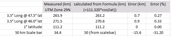
Note the large error from the scale bar (>30% error) and relatively insignificant error on the latitude and longitude measurements (<0.1% error).
Questions:
1. Why would the scale bar length be inaccurate (especially when the image lat-long appear to be projected correctly and can be measured accurately in ArcMap)?
2. Is this an error in my geo-referencing? If so, is there a better method for geo-referencing this type of map image?
3. Am I using an incorrect projection? I believe a projected UTM is appropriate for area calculations and should provide accurate length measurement for features located within the UTM zone.
Any assistance is appreciated. Thanks!
Solved! Go to Solution.
- Mark as New
- Bookmark
- Subscribe
- Mute
- Subscribe to RSS Feed
- Permalink
- Report Inappropriate Content
How do you know that the original image was "IN" GCS?
Was this produced by ArcGIS or something. Because if it was an original printed map or similar, it would actually be in some sort of projected system. Even though it has a GCS graticule marked on it. This is very common.
Thus the corners (like on a standard 50k topo map), might have lat/long coordinates marked, but the map is actually in UTM or whatever system. You can still georeference this, when entering the control point, right click then you will see "Enter XY" and the second option is "Enter DMS". These will be automatically translated into the coordinate system of the data frame, which, of course, should always be the actual coordinate system of the map.
- Mark as New
- Bookmark
- Subscribe
- Mute
- Subscribe to RSS Feed
- Permalink
- Report Inappropriate Content
You are correct in asking about the coordinate systems of original image; the map is from a published journal article and I am NOT sure what coordinate system was used. It is a smaller map (about 1.5 degrees latitude and 3.5 degrees longitude) which has a graticule that make perfect squares and the conversion from degrees latitude (or longitude) to km match the scale bar (at least before it is georeferenced). As a result, I guessed that it used a GCS.
Based on your suggestion, I attempted to georeference the map in a PCS (since I do not know what was used on the original, I used the appropriate UTM zone) using the "Enter DMS" function. This resulted in the same ~30% error in the length of the scale bar with the "Measure" tool.
Is it common for scale bars to have this much error (a 50 km scale bar measures 34.4 km, 30% error) when georeferenced?
- Mark as New
- Bookmark
- Subscribe
- Mute
- Subscribe to RSS Feed
- Permalink
- Report Inappropriate Content
I still see that the original image you posted above, doesn't have an actual "corner coordinate" in Lat/Long, unless there is some other text outside of the snapshot you have given us.
How did you know the exact Lat/Long of that corner?
- Mark as New
- Bookmark
- Subscribe
- Mute
- Subscribe to RSS Feed
- Permalink
- Report Inappropriate Content
Neil, I did not use the true corner in this example (since, as you pointed out, it does not have a "corner coordinate"). As an alternative, I used the tick mark closest to corner, which is 74.5 degrees N latitude/14 degrees W longitude. The lower right and left corners had labeled coordinates, but I used a similar approachfo the upper right corner, i.e., georeferencing the nearest known point (using a tick mark at 74.5 degrees N latitude/8 degrees W longitude).
- Mark as New
- Bookmark
- Subscribe
- Mute
- Subscribe to RSS Feed
- Permalink
- Report Inappropriate Content
Just curious, in that original image the text looks a little "squashed", yet in the "projected" image it looks more normal.
There is something wrong with the coord sys of the original I think.
- Mark as New
- Bookmark
- Subscribe
- Mute
- Subscribe to RSS Feed
- Permalink
- Report Inappropriate Content
It's possible whatever software was used to generate the original image calculated the scale bar at the equator (ArcMap used to do this; I don't know if it still does), rather than at 47N. I get 0.68% reduction east-west ( cos(47) ) which ends up being 34 km / 50 km.
If it was a bathymetry chart, it could be using Mercator with a standard parallel set around 47N to reduce distortion. That would also give a rectangular graticule.
Melita
- Mark as New
- Bookmark
- Subscribe
- Mute
- Subscribe to RSS Feed
- Permalink
- Report Inappropriate Content
The prospect of the original map's scale bar being calculated at the equator seems to be a plausible (and likely) cause of the issue. That would explain why:
- The original and ArcMap scale bars lengths matched when I used a geographic projection system, and both were incorrect. The "50 km" scale bars were only 34.4 km long. This amount of error would be expected at 47N if they were both sourced at the equator.
- And, while using a projected coordinate system, the ArcMap derived scale was correct (50 km = 50 km) and the original maps "50 km" scale bar was still incorrect by the same amount ("50 km" = 34.4 km).
On your second comment: Yes, the original image is a bathymetry chart.
I think this is the explanation: The original scale bar was incorrect because, while using a geographic coordinate system, they included a scale bar sourced at the equator.
Thank you, Melita Kennedy, for providing the answer!
- Mark as New
- Bookmark
- Subscribe
- Mute
- Subscribe to RSS Feed
- Permalink
- Report Inappropriate Content
Luke... could you mark Melita's answer correct please
- Mark as New
- Bookmark
- Subscribe
- Mute
- Subscribe to RSS Feed
- Permalink
- Report Inappropriate Content
Yes! Thanks, Dan.
- « Previous
-
- 1
- 2
- Next »
- « Previous
-
- 1
- 2
- Next »