- Home
- :
- All Communities
- :
- User Groups
- :
- Coordinate Reference Systems
- :
- Questions
- :
- Re: Two maps of Detroit on different sides of the ...
- Subscribe to RSS Feed
- Mark Topic as New
- Mark Topic as Read
- Float this Topic for Current User
- Bookmark
- Subscribe
- Mute
- Printer Friendly Page
Two maps of Detroit on different sides of the globe
- Mark as New
- Bookmark
- Subscribe
- Mute
- Subscribe to RSS Feed
- Permalink
- Report Inappropriate Content
Hello,
I'm a bit new to GIS and am having a bit of an issue
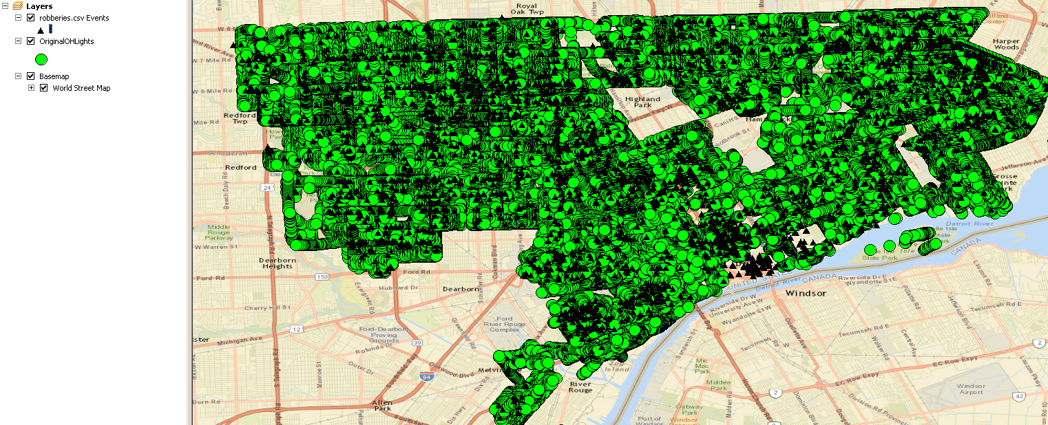
I have a .csv that i have converted into a feature class- the feature class displays correctly(it is a map of all robberies in Detroit in a given year).
I also have a .shp that is all of the locations of the lights in the same city- it also displays correctly, but in a completely different part of the map.
When I add a basemap, the .shp points are all in the correct city, while the .csv created feature class is out in the Atlantic ocean.
I have ensured that all the layers and the data frame are using the same geo reference systems.
I'm at a bit of a loss here.
I've attached both the .shp in a zip and the .csv I'm working with. Any help would be much appreciated.
- Mark as New
- Bookmark
- Subscribe
- Mute
- Subscribe to RSS Feed
- Permalink
- Report Inappropriate Content
without even looking... if it is in North America, the longitudes need to be negative
- Mark as New
- Bookmark
- Subscribe
- Mute
- Subscribe to RSS Feed
- Permalink
- Report Inappropriate Content
Yes, they are negative
- Mark as New
- Bookmark
- Subscribe
- Mute
- Subscribe to RSS Feed
- Permalink
- Report Inappropriate Content
The csv doesn't have a defined coordinate system then and you haven't mixed up longitude (X) and latitude (Y) have you?... copy a few lines and paste to save the whole download and unzip thing.
- Mark as New
- Bookmark
- Subscribe
- Mute
- Subscribe to RSS Feed
- Permalink
- Report Inappropriate Content
Here's what I see when I follow the workflow below:
Here was my workflow:
- Open ArcMap
- Add .csv to TOC
- Right-click on .csv and select "Disply XY Data"
- Select WGS84 as the Geographic Coordinate system, and ensure X = Longitude field and Y = Latitude field
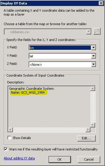
- Results = robberies.csv Events appears in TOC, with points plotted in correct locations.
- Add OriginalOHLights to TOC
- Results = OHLights points appear in correct location
His longitudes are negatives, BTW.
- Mark as New
- Bookmark
- Subscribe
- Mute
- Subscribe to RSS Feed
- Permalink
- Report Inappropriate Content
then the X,Ys could have been swapped... if the negative is missing for longitudes you end up north of the equator but on the wrong side of Greenwich.. If they are swapped, you end up in the southern hemisphere
- Mark as New
- Bookmark
- Subscribe
- Mute
- Subscribe to RSS Feed
- Permalink
- Report Inappropriate Content
Yes sir. He says he's new to GIS, could very much be the case of swapped Xs and Ys.
- Mark as New
- Bookmark
- Subscribe
- Mute
- Subscribe to RSS Feed
- Permalink
- Report Inappropriate Content
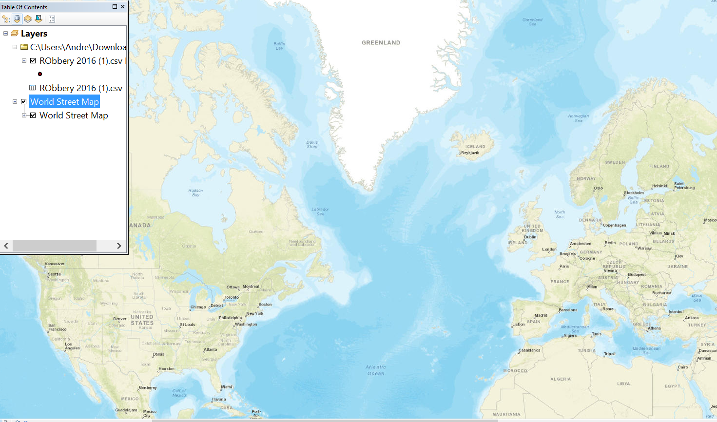
I followed that exact workflow, only to end up with a the map zooming somewhere in the area of greenland
- Mark as New
- Bookmark
- Subscribe
- Mute
- Subscribe to RSS Feed
- Permalink
- Report Inappropriate Content
Nevermind, I am a dork and messed something up. In any case, it works now. Issue seems to be I had a projection of world_auxilary_sphere 1984 chosen.
Thanks for the help!
- Mark as New
- Bookmark
- Subscribe
- Mute
- Subscribe to RSS Feed
- Permalink
- Report Inappropriate Content
ArcMap will always set the dataframe's projection to the first dataset's projection that you add to the TOC. I suspect you had the World Map basemap in your TOC prior to doing anything else, which would explain the world_auxiliary_sphere 1984.