Turn on suggestions
Auto-suggest helps you quickly narrow down your search results by suggesting possible matches as you type.
Cancel
- Home
- :
- All Communities
- :
- Products
- :
- Data Management
- :
- Data Management Questions
- :
- Re: Create an Address Locator with Tiger files
Options
- Subscribe to RSS Feed
- Mark Topic as New
- Mark Topic as Read
- Float this Topic for Current User
- Bookmark
- Subscribe
- Mute
- Printer Friendly Page
Create an Address Locator with Tiger files
Subscribe
7472
11
12-13-2011 12:24 PM
12-13-2011
12:24 PM
- Mark as New
- Bookmark
- Subscribe
- Mute
- Subscribe to RSS Feed
- Permalink
- Report Inappropriate Content
I am trying to create an address locator for the state of Texas (it can be split into 11 regions). I read over the PDF on relationships on the Census Bureau's website(http://www.census.gov/geo/www/tiger/tgrshp2010/TGRSHP10SF1CH6.pdf). They recommend using the All Lines shapefiles which also require the Address Ranges Relationship files for all of the address data. I have downloaded several county All Lines shapefiles and the Address Ranges Relationship files for these counties. I merged the shapefiles for the counties and the tables and now have one shapefile and one table. The Census Bureau says to link these two files using the TLID field. However, it is a one (shapefile) to many (table) relationship since each line segment has multiple address rnages associated with it. I have not created an address locator before, but I understand it needs to be a single file. How can I join these to use them as intended - to create an address locator?
11 Replies
12-13-2011
12:55 PM
- Mark as New
- Bookmark
- Subscribe
- Mute
- Subscribe to RSS Feed
- Permalink
- Report Inappropriate Content
I am trying to create an address locator for the state of Texas (it can be split into 11 regions). I read over the PDF on relationships on the Census Bureau's website(http://www.census.gov/geo/www/tiger/tgrshp2010/TGRSHP10SF1CH6.pdf). They recommend using the All Lines shapefiles which also require the Address Ranges Relationship files for all of the address data. I have downloaded several county All Lines shapefiles and the Address Ranges Relationship files for these counties. I merged the shapefiles for the counties and the tables and now have one shapefile and one table. The Census Bureau says to link these two files using the TLID field. However, it is a one (shapefile) to many (table) relationship since each line segment has multiple address rnages associated with it. I have not created an address locator before, but I understand it needs to be a single file. How can I join these to use them as intended - to create an address locator?
I'm not too familiar with Census data, but the way I'd do it is county by county, rather than one big merged shapefile and table.
See if at a single county level you can join the street segments (shapefile records) to thier respective table records via the TLID. If you are still getting a one to many (one segment to many range records) I don't know how they expect you to use thier data.
That should just about do it....
12-14-2011
07:16 AM
- Mark as New
- Bookmark
- Subscribe
- Mute
- Subscribe to RSS Feed
- Permalink
- Report Inappropriate Content
All of the tables have multiple entries for each street, even at the single county level. They state this in their instructions, right after they say you have to link them so they are aware it is not a simple link but don't say how they think it can be done.
12-14-2011
10:11 AM
- Mark as New
- Bookmark
- Subscribe
- Mute
- Subscribe to RSS Feed
- Permalink
- Report Inappropriate Content
Becky- I couldn't find the 2010 all line files, but I stumbled upon 2008. (Can Census make it a little more cumbersome to navigate the site?!)
Anyway, I downloaded the roads for Anderson County. In this county there are a total of 39874 road segments. 37,672 do not have ranges in the data. When I select those and relate them to the _addr table, nothing gets selected in the related table. There are only 3899 records in the entire related table.
When I switch the selected edges to those that have at least partial (one side or the other) ranges and choose related tables, all of the 3899 get selected.
This whole thing is pretty murky for me; if the edge record has ranges, the _addr file seems to confirm them. But if the edge record hs no range information, the _addr file doesn't provide anything.
Let me know one of the counties you are working on and I'll see what it does for me or if I can make sense of it. If Anderson is one of them, I'm more than dissapointed with the data census provides.
[edited a few minutes later] : Just for fun I downloaded the all lines data for Salt Lake County, Utah. I personally maintain this data for 9-1-1 response. For the most part the geomtries are okay. I did notice however that randomly identifying my streets against the census streets that census will flip rf-rt, lf-lt and even lf with rf and lt with rt. Not sure what's up with that.
That should just about do it....
12-14-2011
12:22 PM
- Mark as New
- Bookmark
- Subscribe
- Mute
- Subscribe to RSS Feed
- Permalink
- Report Inappropriate Content
I submitted a question to the census bureau as well and below is what I heard back today. I am still waiting to find out if I still need to link this shapefile to a table though their description doesn't sound like I will have to. I will test it out this week, even if I don't hear back, and post the results here.
"The 2011 TIGER/Line Shapefiles were released yesterday. This set of shapefiles contains a new shapefile, address range - feature shapefile, which has better geocoding results than the all lines shapefile.
The Address Range-Feature (ADDRFEAT.shp) shapefile contains a record for each address range to street name combination. Address ranges associated to more than one street name are also represented by multiple coincident address range feature edge records. This shapefile includes all unsuppressed address ranges and will have better geocoding address match rates compared to the All Lines Shapefile (EDGES.shp) which only includes the most inclusive address range associated with each side of a street edge.
The TIGER/Line Files contain potential address ranges, not individual addresses. Potential ranges include the full range of possible structure numbers even though the actual structures may not exist. "
12-15-2011
01:35 AM
- Mark as New
- Bookmark
- Subscribe
- Mute
- Subscribe to RSS Feed
- Permalink
- Report Inappropriate Content
I submitted a question to the census bureau as well and below is what I heard back today. I am still waiting to find out if I still need to link this shapefile to a table though their description doesn't sound like I will have to. I will test it out this week, even if I don't hear back, and post the results here.
"The 2011 TIGER/Line Shapefiles were released yesterday. This set of shapefiles contains a new shapefile, address range - feature shapefile, which has better geocoding results than the all lines shapefile.
The Address Range-Feature (ADDRFEAT.shp) shapefile contains a record for each address range to street name combination. Address ranges associated to more than one street name are also represented by multiple coincident address range feature edge records. This shapefile includes all unsuppressed address ranges and will have better geocoding address match rates compared to the All Lines Shapefile (EDGES.shp) which only includes the most inclusive address range associated with each side of a street edge.
The TIGER/Line Files contain potential address ranges, not individual addresses. Potential ranges include the full range of possible structure numbers even though the actual structures may not exist. "
So it sounds like the address range feature shapefile is the one you want. I've worked with streets where the data-maintainer has put the 'exact' range, that is the range of the structures along the street. Personally, I don't see the point in that. When geocoding against a linear feature you are interpolating the location of the address. Since my primary use of geocoding is for 9-1-1 response my feeling is this:
Streets and addresses are typically based on a grid. Use it. Address through intersections. If you want precise locations, use point data; don't massage linear data into a false positive. But that's just me....
Would you mind posting a link to the 2011 data? I'd like to see what they are publishing...
That should just about do it....
12-15-2011
05:24 AM
- Mark as New
- Bookmark
- Subscribe
- Mute
- Subscribe to RSS Feed
- Permalink
- Report Inappropriate Content
12-15-2011
06:28 AM
- Mark as New
- Bookmark
- Subscribe
- Mute
- Subscribe to RSS Feed
- Permalink
- Report Inappropriate Content
Is it just me, or is the Address Feature shapefile not in their 2011 list? Anyway, here's a direct link to the files - http://www2.census.gov/geo/tiger/TIGER2011/ADDRFEAT/
12-15-2011
12:10 PM
- Mark as New
- Bookmark
- Subscribe
- Mute
- Subscribe to RSS Feed
- Permalink
- Report Inappropriate Content
It's there, but hidden under the relationship files - I had to look for a bit. I was able to use this file to successfully geocode one county in my dataset today with 85% accuracy, and that low rate is probably due to errors in my dataset. I did not have to download any additional files to create the address locator. So, I guess the take away is not to use the instructions they provide as they are confusing, and it appears, unnecessary.
12-16-2011
05:30 AM
- Mark as New
- Bookmark
- Subscribe
- Mute
- Subscribe to RSS Feed
- Permalink
- Report Inappropriate Content
It's there, but hidden under the relationship files - I had to look for a bit. I was able to use this file to successfully geocode one county in my dataset today with 85% accuracy, and that low rate is probably due to errors in my dataset. I did not have to download any additional files to create the address locator. So, I guess the take away is not to use the instructions they provide as they are confusing, and it appears, unnecessary.
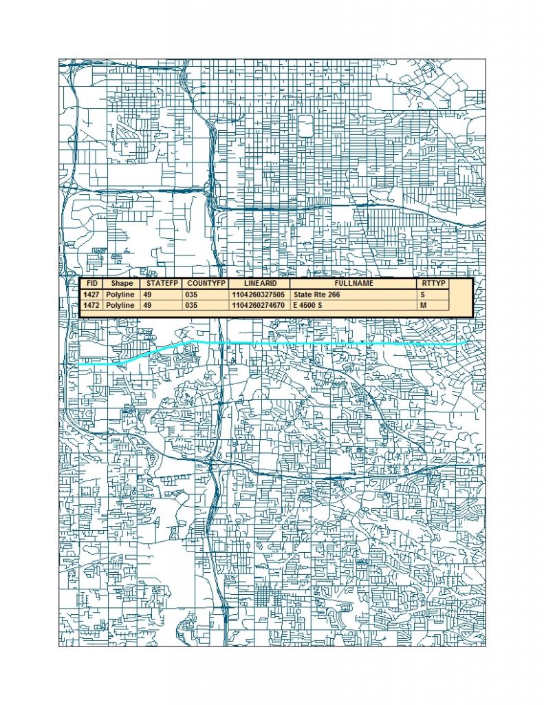
You've got more patience than me; I'm still fumbling around looking for the relationship files. I did take a look at the Salt Lake County Utah data. Wow. Pretty weird to me. See attached map: I selected one short segment and this is what was returned....
Glad it worked for you!
[edited moment s later: ] oohhh; there are the relationship files! Just had to scroll down on the original picklist.... And, the feature class that I downloaded to create the image apparently is the 'wrong' one. I found the address range feature class; like I said earlier, can they make it more difficult to get what you want?
That should just about do it....