- Home
- :
- All Communities
- :
- Industries
- :
- Education
- :
- Education Blog
- :
- Resources for Teaching Introductory Remote Sensing
Resources for Teaching Introductory Remote Sensing
- Subscribe to RSS Feed
- Mark as New
- Mark as Read
- Bookmark
- Subscribe
- Printer Friendly Page
- Report Inappropriate Content
Remote sensing education--courses, programs, and curriculum--have existed since the 1980s. Should it be taught in 2020 and beyond? I would say, absolutely yes, for the following reasons: (1) Remote sensing data sources, from Lidar, UAS, small satellites, and beyond, are rapidly diversifying; (2) Remote sensing applications have spread far beyond natural resource management to city planning, health, natural hazards, engineering, transportation, and many other fields; (3) Remote sensing tools are increasingly intertwined with GIS tools and workflows, for example, in the ArcGIS platform. Thus a combination of GIS and remote sensing skills will be in demand in the workforce--they are no longer semi-separate communities as they were in the 20th Century. And the good news for instructors is that the ArcGIS platform allows you to teach both GIS and remote sensing in a single environment.
If you are "starting up" with teaching remote sensing, or wanting to modernize your existing remote sensing program or curriculum, my opinion is that that a primary objective should be to help students (1) get excited about remote sensing so that they will want to continue their journey in it, and (2) provide some interesting and compelling activities that will enable them to begin investigations right away, and that will make them, later, want to pursue, with your guidance, the scientific foundations behind it as well as more advanced applications.
Some ideas to get started in remote sensing are as follows:
For Hour 1 in a workshop, or Week 1 in a course, start with my weird Earth set of images and teaching strategies to get students thinking spatially and asking spatial questions about patterns, relationships, and the whys of where, here.
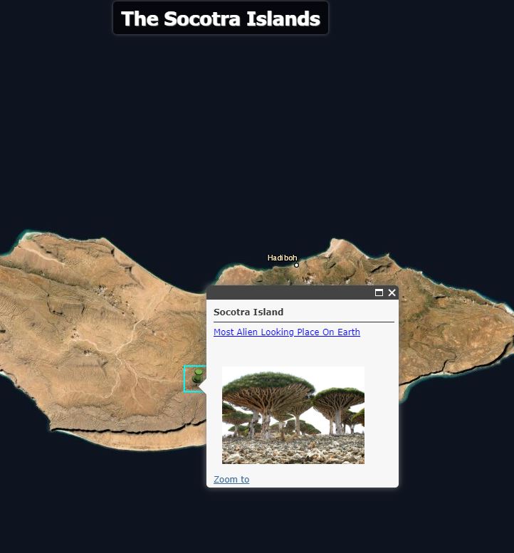
A section of the Weird Earth ArcGIS Online presentation. Why is the vegetation on this island unique?
For related videos on the Weird Earth theme, see the first three videos of mine in this list.
Another resource is to guide students through my "Name that Place" - Presentation
It is in video form, here. "Name that Place" is in quiz form that guarantees engagement, interaction, and interest.
Follow the above with a more detailed investigation of the Earth, using the Landsat Lens viewer to examine changes from natural and human causes:
Landsat Lens These causes could include volcanism, agriculture, the construction of dams and reservoirs, coastal erosion, glacial retreat, urbanization, mining, the shrinkage of lakes such as Lake Chad and the Aral Sea, evidence of political boundaries and differing land use on either side of the border, and many more.
Use the Landsat Explorer app to examine the Earth. This tool allows you to build swipe maps to see change over time and with it, you can examine different band combinations, teaching the electromagnetic spectrum and other fundamental remote sensing concepts in the process:
Examine this real-time weather and maps lesson and maps, part of the Learn Lesson gallery:
Predict Weather with Real-Time Data | Learn ArcGIS Through this lesson, students will understand the importance of real-time satellite imagery, in this case, from NOAA, and products that can be derived from it.
Examine the new European Data Portal that my colleague and I reviewed on our data blog for additional data:
https://spatialreserves.wordpress.com/2016/03/07/european-data-portal-launched/
This blog also contains many other resources about remote sensing data, tools, and sources:
remote sensing | Search Results | Spatial Reserves These include the "top 7 sources for satellite imagery' and the "top 12 Landsat image sources and portals."
For additional data, look at the ArcGIS Living Atlas of the World under imagery.

Searching imagery on the ArcGIS Living Atlas of the World.
Next, dig deeper with some Esri tools. These tools include Image Analyst, where you can dig into stereo imagery, deep learning image classification, and full motion video. UAVs, or drones, have become an essential component in many remote sensing programs in higher education, and even are taught in some secondary schools. Esri's Drone2Map (lesson here) solution and Site Scan. Today, remote sensing is increasingly tied to Artificial Intelligence, which presents exciting new ways to teach and new career pathways for students.
Learn Lessons from Esri on remote sensing provide hands-on work and practice: https://learn.arcgis.com/en/gallery/#?q=remote%20sensing&t=lesson These use a variety of tools including ArcGIS Pro and ArcGIS Online.
The IGETT Remote Sensing project set of lessons provide additional hands-on activities:
http://www.igettremotesensing.org/resources-for-instruction.html
Longstanding tutorials, some of which are lacking in the newer tools but which provide solid foundations, are also useful. For example, https://earthdata.nasa.gov/learn/remote-sensing is NASA's excellent starting point. In addition, https://earthobservatory.nasa.gov/features/RemoteSensing is one I have used for years and years and is still useful.
Are textbooks still a relevant tool in modern remote sensing education? I still have great respect for these foundational textbooks that have a place in instruction, including the following two books:
1) Jensen. Remote Sensing of the Environment - An Earth Resource Perspective.
2) Lillesand & Kiefer's Remote Sensing and Image Interpretation book.
The Esri Press book Making Spatial decisions with Remote Sensing and GIS book was written by two colleagues of mine and provides useful activities and foundations:
https://www.amazon.com/Making-Spatial-Decisions-Remote-Sensing/dp/1589483367
I hope this is helpful and I look forward your comments.
--Joseph Kerski
You must be a registered user to add a comment. If you've already registered, sign in. Otherwise, register and sign in.
-
Administration
39 -
Announcements
45 -
Career & Tech Ed
1 -
Curriculum-Learning Resources
182 -
Education Facilities
24 -
Events
48 -
GeoInquiries
1 -
Higher Education
520 -
Informal Education
266 -
Licensing Best Practices
47 -
National Geographic MapMaker
17 -
Pedagogy and Education Theory
189 -
Schools (K - 12)
282 -
Schools (K-12)
186 -
Spatial data
24 -
STEM
3 -
Students - Higher Education
232 -
Students - K-12 Schools
88 -
Success Stories
22 -
TeacherDesk
1 -
Tech Tips
83
- « Previous
- Next »