Turn on suggestions
Auto-suggest helps you quickly narrow down your search results by suggesting possible matches as you type.
Cancel
Sharing Data through Story Maps
Subscribe
753
0
04-28-2016 11:59 PM
- Subscribe to RSS Feed
- Mark as New
- Mark as Read
- Bookmark
- Subscribe
- Printer Friendly Page
- Report Inappropriate Content
04-28-2016
11:59 PM
Many methods of sharing mapped data are now available and easy to use. Using these methods can foster critical and spatial thinking by engaging the ArcGIS platform. We have written about a variety of ways to share mapped data in this blog. One method is to create a spreadsheet, publish it to ArcGIS Online, and making it editable in the field to enable you... to do citizen science-based mapping. Another idea we wrote about is to crowdsource your photographs that can be used in multimedia maps. We have also written about the many ways that you and your students can map their field data. With increasing interest in story maps, how can data from more than one student be shown in a story map?
Several methods exist for educators and students to create data in the field or in the classroom and map it via a story map, with more on the way. One way is to create a map in ArcGIS Online that includes an editable feature service, as shown in this example where I invite educators to map tree species on their campuses. You can then create a story map, such as the one shown below. Here, I chose the "basic story map" when I shared my map to a web mapping application. The story map updates each time tree data is added. Data can be added in the field using the Collector for ArcGIS app if the map has been shared with a group and the user has been invited to that group. Data can also be added via a web browser on a laptop or tablet computer, and if the map has been shared publicly, with no log in required.
While you cannot have multiple editors work on a single story map, one method for instruction is to designate a person in your class whose ArcGIS Online account keeps the "master" story map. Other students develop content in ArcGIS Desktop, Pro, or Online that they upload and share that content with their peers within their Group in ArcGIS Online. Then, the person responsible for the master map searches for that content and adds it to their ArcGIS Online map. The story map, as in the example I show below, automatically updates because it is pointing to the original editable map.
I mentioned above that "more methods are on the way." These include the upcoming crowdsourcing story map application, so keep an eye on this blog for further updates.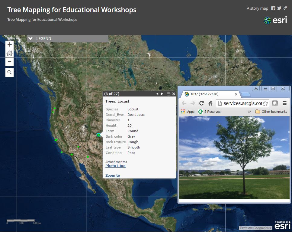
Crowdsourced Tree Mapping Project in a Story Map.
You must be a registered user to add a comment. If you've already registered, sign in. Otherwise, register and sign in.
About the Author
I believe that spatial thinking can transform education and society through the application of Geographic Information Systems for instruction, research, administration, and policy.
I hold 3 degrees in Geography, have served at NOAA, the US Census Bureau, and USGS as a cartographer and geographer, and teach a variety of F2F (Face to Face) (including T3G) and online courses. I have authored a variety of books and textbooks about the environment, STEM, GIS, and education. These include "Interpreting Our World", "Essentials of the Environment", "Tribal GIS", "The GIS Guide to Public Domain Data", "International Perspectives on Teaching and Learning with GIS In Secondary Education", "Spatial Mathematics" and others. I write for 2 blogs, 2 monthly podcasts, and a variety of journals, and have created over 5,000 videos on the Our Earth YouTube channel.
Yet, as time passes, the more I realize my own limitations and that this is a lifelong learning endeavor and thus I actively seek mentors and collaborators.
Related Articles
Sharing Data Through Story Maps
JosephKerski
Esri Notable Contributor
0 Kudos
0 Comments
Labels
-
Administration
39 -
Announcements
47 -
Career & Tech Ed
1 -
Curriculum-Learning Resources
187 -
Education Facilities
24 -
Events
49 -
GeoInquiries
1 -
Higher Education
524 -
Informal Education
266 -
Licensing Best Practices
47 -
National Geographic MapMaker
17 -
Pedagogy and Education Theory
191 -
Schools (K - 12)
282 -
Schools (K-12)
190 -
Spatial data
24 -
STEM
3 -
Students - Higher Education
232 -
Students - K-12 Schools
90 -
Success Stories
22 -
TeacherDesk
1 -
Tech Tips
84
- « Previous
- Next »