Turn on suggestions
Auto-suggest helps you quickly narrow down your search results by suggesting possible matches as you type.
Cancel
What did you do for GIS Day?
Subscribe
229
0
11-19-2015 11:00 PM
- Subscribe to RSS Feed
- Mark as New
- Mark as Read
- Bookmark
- Subscribe
- Printer Friendly Page
- Report Inappropriate Content
11-19-2015
11:00 PM
What did you do for GIS Day this year? Since 1999, GIS Day has been set aside to promote, celebrate, and demonstrate the real-world applications that are making a difference in society using Geographic Information Systems technology.
GIS Day always occurs during the Wednesday of Geography Awareness Week, and thus provides a good excuse for incorporating geographic perspectives, geography content, and spatial thinking into the activities.
I had a great GIS Day and Geography Awareness Week. As the week began, I finished presenting and exhibiting at the National Council for the Social Studies conference in New Orleans, where I met some wonderful economics, geography, history, and civics instructors. I then flew to Philadelphia and visited one of my favorite programs that use GIS to make a positive difference in the lives of young people, Hopeworks 'N Camden. Hopeworks 'N Camden is a nonprofit that has been working for over 15 years with Camden youth. Utilizing an advanced training curriculum in web design and development, GIS, and Salesforce, Hopeworks works with youth aged 14-23 to get back in school and discover a safe pathway to their future. One of their projects with GIS involves mapping all of the city's water infrastructure--valves, fire hydrants, and mains--for the American Water Works Company.
Next, I visited Temple University's Department of Geography and Urban Studies, which recently began a new undergraduate GIS certificate program. Next, I was invited to Penn State University to support their GIS Day activities, teaching a workshop, operating an information table, giving a presentation, and meeting with their innovative faculty across the campus who are using GIS in their courses and programs. I also highly enjoyed speaking to two classes--an undergraduate course in professional development for geography students, and a first year seminar for earth and environmental students. Next, I visited Cornell University in New York, teaching a hands-on workshop for students and faculty, followed the next day by a workshop for the New York 4H community, In all of these visits I was highly encouraged by the energy and expertise of the students, staff, and faculty, and did my utmost to give plenty of encouragement and support in return.
Share the stories of what you did on the GIS Day web site, by replying to this essay below, or in GeoNet.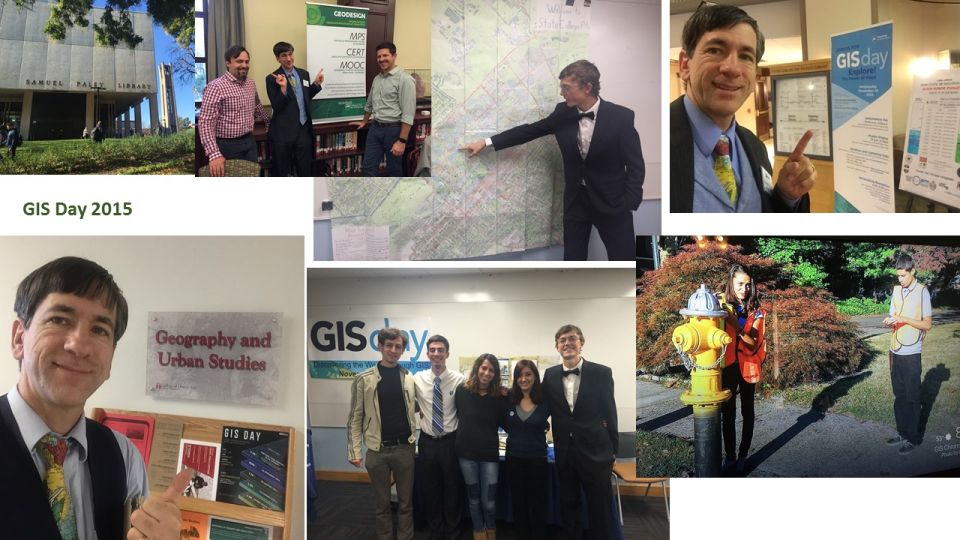
GIS Day events: Working with faculty, staff, and students.
You must be a registered user to add a comment. If you've already registered, sign in. Otherwise, register and sign in.
About the Author
I believe that spatial thinking can transform education and society through the application of Geographic Information Systems for instruction, research, administration, and policy.
I hold 3 degrees in Geography, have served at NOAA, the US Census Bureau, and USGS as a cartographer and geographer, and teach a variety of F2F (Face to Face) (including T3G) and online courses. I have authored a variety of books and textbooks about the environment, STEM, GIS, and education. These include "Interpreting Our World", "Essentials of the Environment", "Tribal GIS", "The GIS Guide to Public Domain Data", "International Perspectives on Teaching and Learning with GIS In Secondary Education", "Spatial Mathematics" and others. I write for 2 blogs, 2 monthly podcasts, and a variety of journals, and have created over 5,000 videos on the Our Earth YouTube channel.
Yet, as time passes, the more I realize my own limitations and that this is a lifelong learning endeavor and thus I actively seek mentors and collaborators.
Related Articles
What did you do for GIS Day 2021?
JosephKerski
Esri Notable Contributor
5 Kudos
0 Comments
What did you do for GIS Day 2020?
JosephKerski
Esri Notable Contributor
2 Kudos
0 Comments
What did you do for GIS Day?
JosephKerski
Esri Notable Contributor
1 Kudos
0 Comments
Labels
-
Administration
39 -
Announcements
47 -
Career & Tech Ed
1 -
Curriculum-Learning Resources
185 -
Education Facilities
24 -
Events
49 -
GeoInquiries
1 -
Higher Education
523 -
Informal Education
266 -
Licensing Best Practices
47 -
National Geographic MapMaker
17 -
Pedagogy and Education Theory
189 -
Schools (K - 12)
282 -
Schools (K-12)
188 -
Spatial data
24 -
STEM
3 -
Students - Higher Education
232 -
Students - K-12 Schools
89 -
Success Stories
22 -
TeacherDesk
1 -
Tech Tips
83
- « Previous
- Next »