- Home
- :
- All Communities
- :
- Products
- :
- Geoprocessing
- :
- Geoprocessing Questions
- :
- Clip to export - maintaining symbology.
- Subscribe to RSS Feed
- Mark Topic as New
- Mark Topic as Read
- Float this Topic for Current User
- Bookmark
- Subscribe
- Mute
- Printer Friendly Page
- Mark as New
- Bookmark
- Subscribe
- Mute
- Subscribe to RSS Feed
- Permalink
- Report Inappropriate Content
Morning all. I apologize if I ask this in the wrong place, and my apologies if this has been covered in another thread. I tried to filter down to browse topics similar.
I currently use ArcGIS 10.2.2 for Desktop. Source data is a local sqlexpress dbase. I have many layers - some points, lines, polys....but I have a lot of custom symbology. I usually just have to run intersects based off of census block information, but on occasion there are additional requests. (some FCC related and some DOT related).
What I have been trying to figure out is a couple of things.
1. Clip by shape or poly keeping all my data on my viewable layers. [I believe I have this down pat and working]
2. The process after the clip is exporting or saving as - another format but keeping my symbology intact.
This is where I am failing miserably. I haven't quite figured out (I am a noob still) how to extract the map/clipped area and maintain my symbology.
If this is vague, it is not intentional. I have played with exporting as a DGN_V8 (DOT purposes for testing) and even though layers and information was retained: the symbology was missing.
Any advice much appreciated.
Terry
Solved! Go to Solution.
Accepted Solutions
- Mark as New
- Bookmark
- Subscribe
- Mute
- Subscribe to RSS Feed
- Permalink
- Report Inappropriate Content
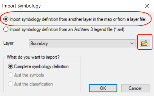
The process I would follow would be to right-click on the layer you plan to clip, and which has the desired symbology applied, then select the Save As Layer File option. This saves the symbology.

Then do your clip and then apply the symbology from the layer file you have just saved. To do so, open the Layer Properties, then Symbology tab, then click on Import.. and browse to your layer file.
- Mark as New
- Bookmark
- Subscribe
- Mute
- Subscribe to RSS Feed
- Permalink
- Report Inappropriate Content
The process I would follow would be to right-click on the layer you plan to clip, and which has the desired symbology applied, then select the Save As Layer File option. This saves the symbology.
Then do your clip and then apply the symbology from the layer file you have just saved. To do so, open the Layer Properties, then Symbology tab, then click on Import.. and browse to your layer file.