- Home
- :
- All Communities
- :
- Products
- :
- Geoprocessing
- :
- Geoprocessing Questions
- :
- Re: Fishnet - Origin Point is Offset
- Subscribe to RSS Feed
- Mark Topic as New
- Mark Topic as Read
- Float this Topic for Current User
- Bookmark
- Subscribe
- Mute
- Printer Friendly Page
- Mark as New
- Bookmark
- Subscribe
- Mute
- Subscribe to RSS Feed
- Permalink
- Report Inappropriate Content
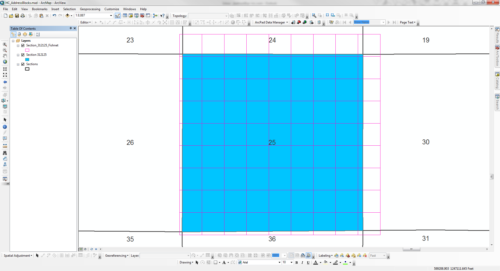
Procedure: Create a fishnet using a single PLSS Section as the template extent feature
Issue: The origin point of the resulting fishnet is always offset to the southwest regardless of how the origin point coordinates are input - automatically through Template Extent or manually.
Environment
ArcGIS Version: 10.0 SP 5 and 10.3
Coordinate System: NAD_1983_StatePlane_Florida_West_FIPS_0902_Feet
Data Frame Display: Feet
Create Fishnet Geoprocessing Window

Fishnet Results
Solved! Go to Solution.
Accepted Solutions
- Mark as New
- Bookmark
- Subscribe
- Mute
- Subscribe to RSS Feed
- Permalink
- Report Inappropriate Content
Ultimately I went with a tool designed by @Ian Broad. It worked as I was hoping Fishnet would, although I had to add the section outside border afterwards. No biggie.
- Mark as New
- Bookmark
- Subscribe
- Mute
- Subscribe to RSS Feed
- Permalink
- Report Inappropriate Content
yes...but what values did you specify and or select in either case. If you want a particular fishnet to fit into a know area, then you need to determine the exact extent (LBRT) then either specify the number of rows and cols and it will calculate the cell sizes, alternately, specify the sizes and it will determine the number of rows and cols...which may extend outside the bounds of the input shape.
You will only get perfect alignment if the shape is a perfectly oriented NS - EW rectangle... any rotation will through the 'look' off.
- Mark as New
- Bookmark
- Subscribe
- Mute
- Subscribe to RSS Feed
- Permalink
- Report Inappropriate Content
You can see in the first screenshot that the left-bottom and right-top numbers from the template feature are the same as the origin and opposite corner values. So I can't imagine how an offset to the southwest occurs with those numbers being identical. I do agree with you on the alignment though, this was not a 90-degree angle that I was working with.
- Mark as New
- Bookmark
- Subscribe
- Mute
- Subscribe to RSS Feed
- Permalink
- Report Inappropriate Content
Following the Create Fishnet tool help from scratch I didn't have the same issue in the same corner, rather my issue is that sections in Florida aren't necessarily square nor aligned to the reference system.
I believe the error you are trying to fix is caused by the use of the optional "Template Extent" instead of just putting the origin you want in the "origin coordinate" and the upper left coordinate in the "y-axis coordinate" input boxes. (Fishnets can easily be rotated to match imperfect north/south alignment and they can deal with rectangular sections that don't have perfect mile-long sides but they don't do so well on non-rectangular sections.)
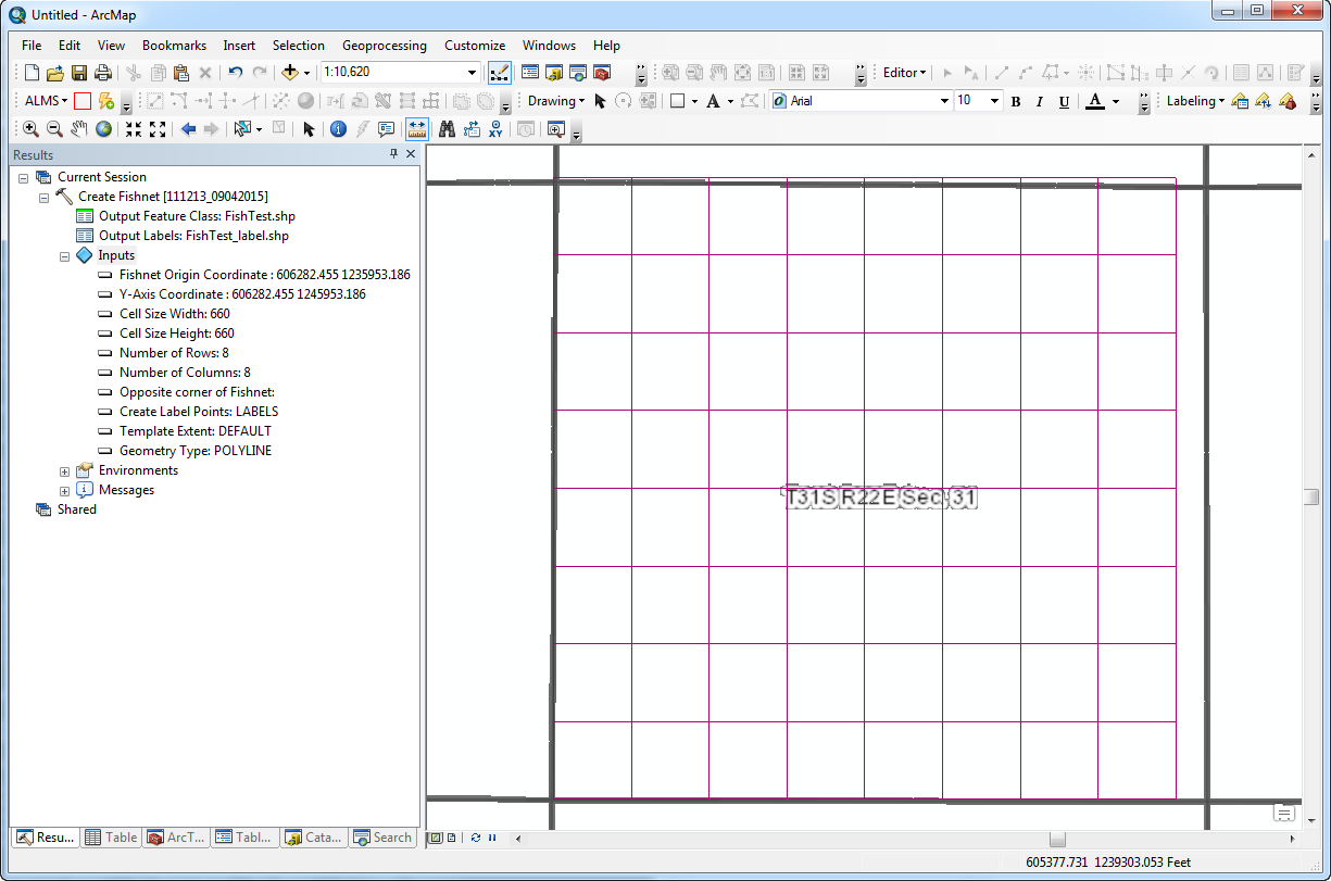
The data frame is NAD_1983_StatePlane_Florida_West_FIPS_0902_Feet.
Origin= 606282.455 1235953.186,
Y-axis= 606282.455 1245953.186.
Cell size width/height = 1/8 mile
Rows and columns = 8
ArcGIS 10.2.2
The fishnet is 5280 feet by 5280 feet. In this case, the fishnet is oriented plumb with the spatial reference system but it can be easily rotated around the point of origin by changing the "y-axis coordinate" value. Because sections are not perfectly square ("sides intersect at 90 degrees" sense of the word) and the corners are not exactly 5280 feet apart from each other means that the fishnet won't really line up in any other corner of the section.
...
If you are ultimately after aliquot parts of sections (the square miles that PLSS is based on), you have to trust that the fishnet derived outcome is going to be "loose" and the error in both of our screen shots are probably not that far off from the other errors we will get when going down this path.
Maybe you could just use wider lines? ; )
There are probably as many reasons why sections are not square as there are efforts/methods to make aliquot parts with GIS. If you are not trying to make aliquot parts with fishnets, food for thought for readers that are thinking of that.
- Mark as New
- Bookmark
- Subscribe
- Mute
- Subscribe to RSS Feed
- Permalink
- Report Inappropriate Content
My assumption that a manually-entered origin point and one created by selecting the feature template would be the same is one born of laziness and from reading the tool help. If they are not the same then that's a bug.
- Mark as New
- Bookmark
- Subscribe
- Mute
- Subscribe to RSS Feed
- Permalink
- Report Inappropriate Content
Ultimately I went with a tool designed by @Ian Broad. It worked as I was hoping Fishnet would, although I had to add the section outside border afterwards. No biggie.
- Mark as New
- Bookmark
- Subscribe
- Mute
- Subscribe to RSS Feed
- Permalink
- Report Inappropriate Content
Glad you found Ian's tool. It looks like it more closely approximates aliquot parts (which it seems is your ultimate goal rather than "making a proper fishnet") by finding the corner vertices of polygons and subdividing between them. Using the right tool for the job is a pretty good way to make the job easier.
Ignoring the tool talk and focusing on fishnets for future fishnetters, the comments didn't seem to pick up on my implication that the template corner is not actually the lower left vertice of the data that it was assumed to be.
1. "Doveryai no proveryai" (trust, but verify) with GIS, especially with help pages. Many nuances are lost in the simplified versions users are presented and in a closed source software system it can be difficult to fully discover them.
2. Without the template data or a little more detail / description of the template used it is hard to say it wasn't creating the fishnet precisely as requested, from the template's lower left coordinate which may or may not be a vertex.
3. If there is rotation and other irregularities of the template/target, an out-of-the-box polygon creation tool would be more unlikely to produce hoped for results. Rotation could also be a factor in explaining the phenomena of the previous bullet.