- Home
- :
- All Communities
- :
- Products
- :
- Geoprocessing
- :
- Geoprocessing Questions
- :
- Re: Will GME 0-7-4 work with ArcMap 10.5?
- Subscribe to RSS Feed
- Mark Topic as New
- Mark Topic as Read
- Float this Topic for Current User
- Bookmark
- Subscribe
- Mute
- Printer Friendly Page
Will GME 0-7-4 work with ArcMap 10.5?
- Mark as New
- Bookmark
- Subscribe
- Mute
- Subscribe to RSS Feed
- Permalink
- Report Inappropriate Content
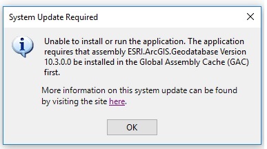
Have installed R full package, trying to install GME 0_7_4 gives the attached error. It actually installed the first time but didn't have a connection to R. Now it won't install and I have a suspicion it's because I'm running 10.5, but why did it install before? Does anyone have any insight on this?
- Mark as New
- Bookmark
- Subscribe
- Mute
- Subscribe to RSS Feed
- Permalink
- Report Inappropriate Content
I am also wondering the same thing.... we want to update ArcGIS from 10.3 to 10.5, however we are unsure if GME will still be compatible.
- Mark as New
- Bookmark
- Subscribe
- Mute
- Subscribe to RSS Feed
- Permalink
- Report Inappropriate Content
No... I had a student call me from a boat off the coast of Alaska that was having issues with getting it to work... Fortunately someone on board had 10.3 so they were good to go. I suspect the project has been abandoned/shelved since there has been no update since the 10.3 version. Lesson... next time you get on a boat, make sure you have your prof's text number 
- Mark as New
- Bookmark
- Subscribe
- Mute
- Subscribe to RSS Feed
- Permalink
- Report Inappropriate Content
Wow, your student dodged one there, glad it all worked out Dan. Would you know about any scripts in Python or R that are floating around where I could run the Step Selection Function (SSF) without the need of GME + ArcMap? Or even how the SSF was written so I could replicate it in pure Python or R.
Also, do you know why GME is not compatible with 10.5? I am curious.
- Mark as New
- Bookmark
- Subscribe
- Mute
- Subscribe to RSS Feed
- Permalink
- Report Inappropriate Content
to all the above... don't know, but you have the algorithm rolling it out in either would probably be easy. I find a lot of the GME stuff are common algorithms with a bio-like name flung on. As for the last question, I haven't had the time to see the exact reason for the problem. The 'fix' is somehow tied to the non-python/R level since neither has substantially changed (it isn't a python 3.x issue for sure)
- Mark as New
- Bookmark
- Subscribe
- Mute
- Subscribe to RSS Feed
- Permalink
- Report Inappropriate Content
I ended up figuring it all out using R. I imported my GPS data and converted the date/time attributes to POSIXct / POSIXt data types. Using the ltraj funtion from the 'adehabitatLT' package I created a trajectory object which calculated the observed distances and turn angles. Next I used the rdSteps function from the 'hab' package to calculate a random step distribution, creating my predicted points from the generated empirical distribution. Finally I used the 'sp' package to create the step lines from each observed point to predicted point and exported all my data into shapefile formats. What a ride!