- Home
- :
- All Communities
- :
- Products
- :
- Imagery and Remote Sensing
- :
- Imagery Questions
- :
- Re: How to generalize busy part of a DEM before ma...
- Subscribe to RSS Feed
- Mark Topic as New
- Mark Topic as Read
- Float this Topic for Current User
- Bookmark
- Subscribe
- Mute
- Printer Friendly Page
How to generalize busy part of a DEM before making a hillshade.
- Mark as New
- Bookmark
- Subscribe
- Mute
- Subscribe to RSS Feed
- Permalink
- Report Inappropriate Content
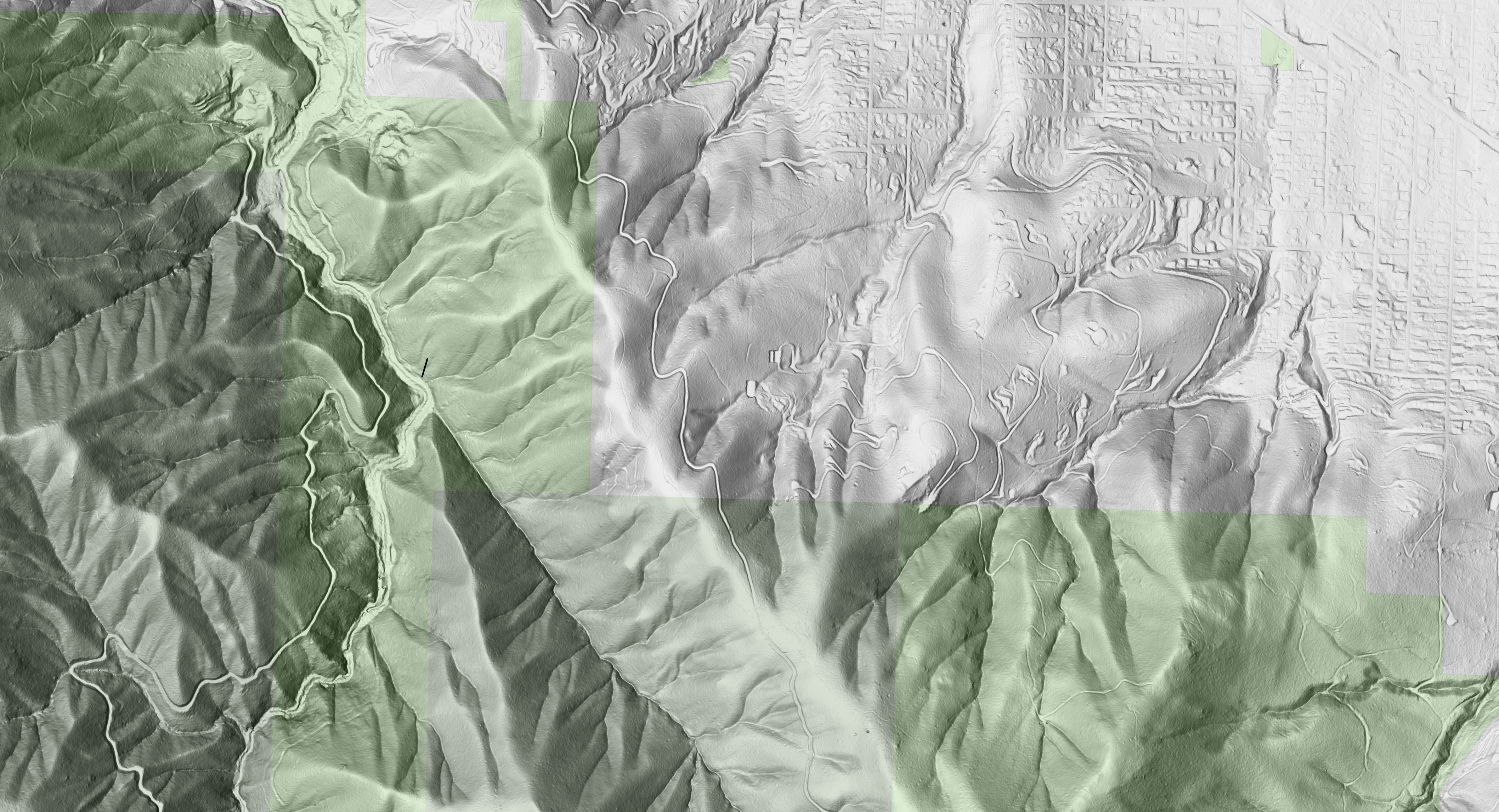
Hello,
Is there some kind of function that I can run on a DEM before I make a hillshade that would mask out the building pads, driveways and roadbeds? I want to show the beauty of the terrain without the distraction of the land disturbances in the more urban area. My final map will bridge the edge of the city and the wilder public lands to our south.
Thanks for any advice.
See image below:
Solved! Go to Solution.
Accepted Solutions
- Mark as New
- Bookmark
- Subscribe
- Mute
- Subscribe to RSS Feed
- Permalink
- Report Inappropriate Content
I'm not sure which version you are running, but the Contour raster function has the ability to apply smoothing to the DEM with a variety of parameters (and then you can omit the contour creation if all you want is the smoothed DEM). The key advantage is that the smoothing is adaptive, depending on the steepness of the terrain, so you don't smooth out important ridges and valleys trying to hide the cul-de-sacs.
Other advantages of using this function are that you can see the result instantly, and you don't have to consume more disk space with a new raster file.
Hopefully you're on Pro or 10.6 (built in); this screenshot from Pro 2.2. Depending on your version you may have to download it http://esriurl.com/contourFunction

Cody B
- Mark as New
- Bookmark
- Subscribe
- Mute
- Subscribe to RSS Feed
- Permalink
- Report Inappropriate Content
And you have ruled out some 'filtering' of the original data prior to determining the hillshade?
Focal Statistics—Help | ArcGIS Desktop
various options exist
or would the bidirectional hillshade make it worse?
- Mark as New
- Bookmark
- Subscribe
- Mute
- Subscribe to RSS Feed
- Permalink
- Report Inappropriate Content
Thank you for your response, Dan.
Yes, I was asking for direction as to what kind of filter might help this particular issue. I will look at Focal Stats and try a couple of options. Is there one that you would suggest?
This example hillshade was completed using the multi-directional function in Pro. I do not see one for bidirectional in there. Am I missing something?
- Mark as New
- Bookmark
- Subscribe
- Mute
- Subscribe to RSS Feed
- Permalink
- Report Inappropriate Content
try a 5x5 or 3x3 focal mean as a first try... you are sortof entering the 'art' end of the science.
misspoke … multidirectional it is
- Mark as New
- Bookmark
- Subscribe
- Mute
- Subscribe to RSS Feed
- Permalink
- Report Inappropriate Content
I'm not sure which version you are running, but the Contour raster function has the ability to apply smoothing to the DEM with a variety of parameters (and then you can omit the contour creation if all you want is the smoothed DEM). The key advantage is that the smoothing is adaptive, depending on the steepness of the terrain, so you don't smooth out important ridges and valleys trying to hide the cul-de-sacs.
Other advantages of using this function are that you can see the result instantly, and you don't have to consume more disk space with a new raster file.
Hopefully you're on Pro or 10.6 (built in); this screenshot from Pro 2.2. Depending on your version you may have to download it http://esriurl.com/contourFunction
Cody B
- Mark as New
- Bookmark
- Subscribe
- Mute
- Subscribe to RSS Feed
- Permalink
- Report Inappropriate Content
Thank you Cody. I will give that a try too.
- Mark as New
- Bookmark
- Subscribe
- Mute
- Subscribe to RSS Feed
- Permalink
- Report Inappropriate Content
Cody, this absolutely worked like a charm and was easy to do. I am working with the settings to dial it in better, but I am almost there. Thank you for the suggestion.
- Mark as New
- Bookmark
- Subscribe
- Mute
- Subscribe to RSS Feed
- Permalink
- Report Inappropriate Content
I am glad it is working for you. Please post some results!
Cody B