- Home
- :
- All Communities
- :
- Products
- :
- Imagery and Remote Sensing
- :
- Imagery Questions
- :
- Re: How to make a mosaic from WW2 aerial survey ph...
- Subscribe to RSS Feed
- Mark Topic as New
- Mark Topic as Read
- Float this Topic for Current User
- Bookmark
- Subscribe
- Mute
- Printer Friendly Page
How to make a mosaic from WW2 aerial survey photographs?
- Mark as New
- Bookmark
- Subscribe
- Mute
- Subscribe to RSS Feed
- Permalink
- Report Inappropriate Content
The archives here on Ssipan, CNMI contain a set of photographs from a 1945 US Navy or Army aerial survey of the entire island of Saipan.
My task is to combine them into a single photographic image file.
The photos are b&w and approximately 10" x 10".
The facility where the photographs are archived has a 600 dpi scanner.
I have access to the photographs only and not the original negatives.
Do you have any suggestions on the best way for me to proceed?
Thanks.
john
- Mark as New
- Bookmark
- Subscribe
- Mute
- Subscribe to RSS Feed
- Permalink
- Report Inappropriate Content
john,
The basics of ESRI GIS concepts and knowledge, including raster, are highly required, before you start taking action. Good idea to take an ESRI training course as well.
Please refer to http://support.esri.com/en/knowledgebase/Gisdictionary/browse and http://learn.arcgis.com/en/
- Mark as New
- Bookmark
- Subscribe
- Mute
- Subscribe to RSS Feed
- Permalink
- Report Inappropriate Content
Thanks Larry. I wish there was a simple way to accomplish this task without a lot of previous GIS and Arcmap knowledge but I keep hitting roadblocks:
1. Add images. 2. Reference images. 3. Mosaic images.
That seems straightforward enough but I guess not.
Thanks again.
john
- Mark as New
- Bookmark
- Subscribe
- Mute
- Subscribe to RSS Feed
- Permalink
- Report Inappropriate Content
Pls follow at Youtube Georeferencing in ArcMap Tutorial: http://youtu.be/PHtxbpboDro
- Mark as New
- Bookmark
- Subscribe
- Mute
- Subscribe to RSS Feed
- Permalink
- Report Inappropriate Content
Thanks Larry. I'll check it out.
Best,
john
- Mark as New
- Bookmark
- Subscribe
- Mute
- Subscribe to RSS Feed
- Permalink
- Report Inappropriate Content
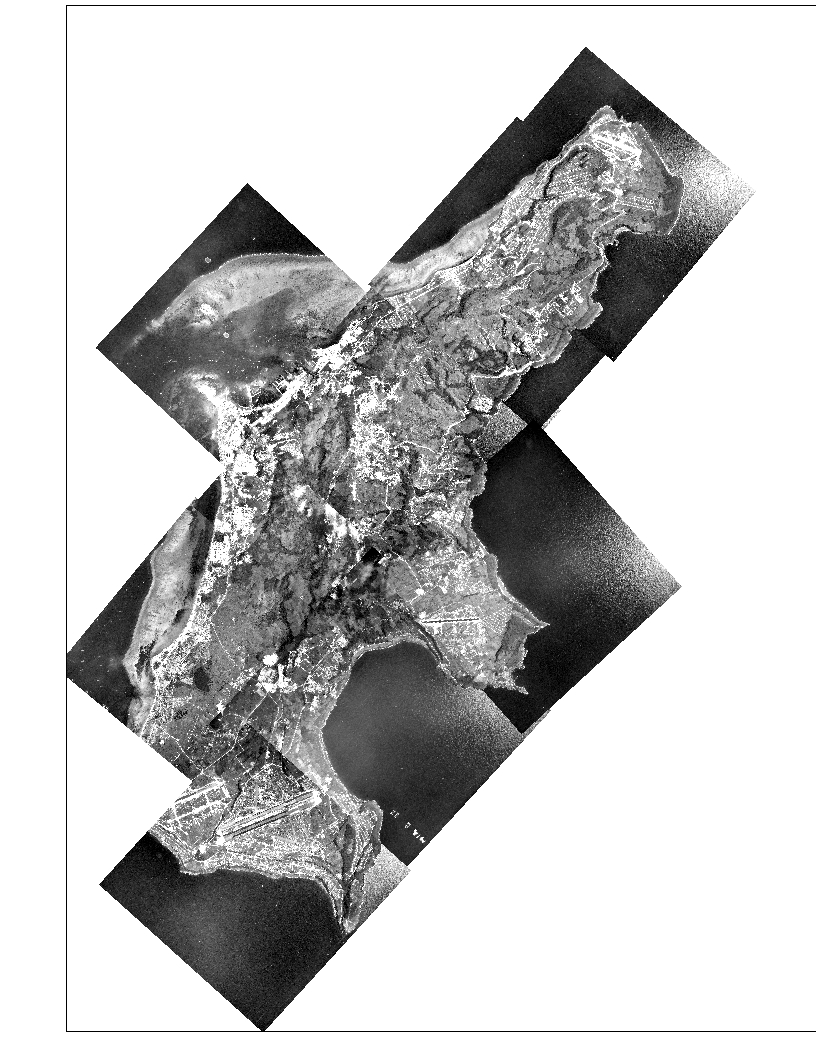
Hello all,
The ten images which I mentioned in my first post have now been georeferenced using esri World Imagery. Attached are the ten images at 50% opacity 1. by themselves and 2. overlaying the World Imagery map. 

As you can see, there is a lot of overlap and features do not necessarily match up in the overlapping areas despite being georeferenced.
I was wondering if it would be any better first mosaic the images in Photoshop before referencing them?
One contributor mention orthorectifying the images to be part of this process. Can I save that step for later or possibly not do that at all if the mosaicked image alone seems suitable for my purpose?
Does anyone have suggestions for how to proceed from here.
Thanks.
john
- Mark as New
- Bookmark
- Subscribe
- Mute
- Subscribe to RSS Feed
- Permalink
- Report Inappropriate Content
Let me just say, it's extremely admirable that you've got this far without any prior experience. Well done! The screenshot of your georeferenced images actually looks pretty good. I don't see any major discrepancies, as far as differences in features on the ground. The only issue I see, is a difference in brightness and contrast. I think you have a good idea of mosaicking them in photoshop first. That will be an easier process for matching the contrast. At least now you know how to do the process, and can redo it for the mosaicked image.
One quick question though. What do you plan to do with these images now? Use them for measuring and analysis, or just make a pretty map? If analysis will be required, what spatial reference did you give the images, that is, what coordinate system has been applied?
- Mark as New
- Bookmark
- Subscribe
- Mute
- Subscribe to RSS Feed
- Permalink
- Report Inappropriate Content
Ps, I wouldn't worry about orthorectifying them, judging by the match you got.
- Mark as New
- Bookmark
- Subscribe
- Mute
- Subscribe to RSS Feed
- Permalink
- Report Inappropriate Content
Thanks. I didn't figure out a way to mosaic the ten images in Photoshop. I went ahead and georeferenced them once more onto a different image of the island with a 0.5m resolution that was taken in 2011.
Two questions:
1. With regard to the contrast and brightness: Is there a way to batch process all ten images so they will come out with the same values? I can do that by hand but they are not going to match exactly and probably won't look good.
2. The residuals and RMS error on one of the images is particularly bad, RMS error being over 30 meters vs 10-20 on most other images. This image with the poor RMS is from the center of the island and stretches from coast to coast at sea level over central Mt Topachau which is about 450m high. Although the images are 2D, I'm wondering if the big difference in elevations in the image might account for the large residuals and RMS error. Thanks.
Best regards,
john
- Mark as New
- Bookmark
- Subscribe
- Mute
- Subscribe to RSS Feed
- Permalink
- Report Inappropriate Content
Problem: One of the ten images went missing from the mosaic when I opened up the file again after closing ArcMap.
The missing image(#9) is at the very bottom left corner of the mosaic. Below are before and after images for comparison. It happens that the top image is cut off at the top but it's the bottom left corner of the images I'm referring to.
When I examined the properties of image # 9, I noticed that the extent had changed so it's gone to another part of the world at: left -774681510.957742; right 765587077.215732; top 1002030686.2084 and bottom 992902249.935427. I reloaded the original links to image 9 several times but that didn't do anything to change the new extent numbers.
Next I removed image 9 entirely and replaced it with a new copy of that image with a different name. After I added the links, the new image 9 was in its proper place in the mosaic.
However, after I closed and reopened the file with new image 9, the NEW image was missing, just a before. New #9's properties indicate that it now has a different extent in some other part of the world.
Can you help me figure out what is happening to change the image extent when I close and reopen the mosaic file?
This extent change did happen once before with a previous mosaic. I never had to deal with that though because I made another mosaic. Thanks.
 begun 2015-07-30 fin 8-15.jpg)
- Mark as New
- Bookmark
- Subscribe
- Mute
- Subscribe to RSS Feed
- Permalink
- Report Inappropriate Content
Regarding the above post: Please ignore it. I made yet another mosaic of the aerial photos, replacing the missing photo with another copy. It works and reopens OK after I close it. Thanks.
john