- Home
- :
- All Communities
- :
- Products
- :
- Imagery and Remote Sensing
- :
- Imagery Questions
- :
- Re: Lidar Data Processing, (Diagonal gray lines ac...
- Subscribe to RSS Feed
- Mark Topic as New
- Mark Topic as Read
- Float this Topic for Current User
- Bookmark
- Subscribe
- Mute
- Printer Friendly Page
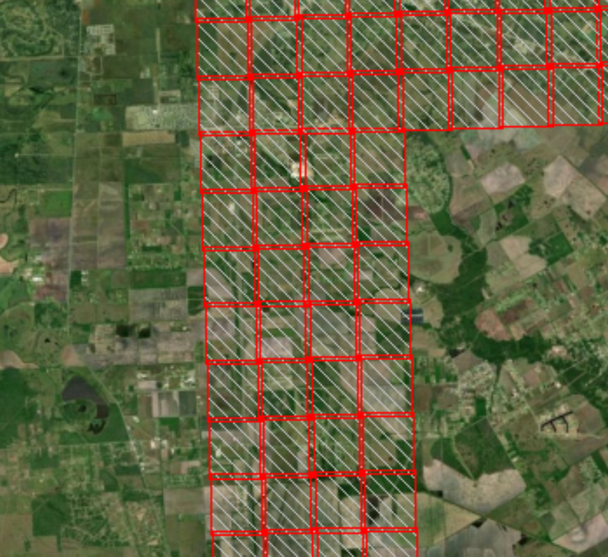
Lidar Data Processing, (Diagonal gray lines across extent for some of downloaded Lidar data)
- Mark as New
- Bookmark
- Subscribe
- Mute
- Subscribe to RSS Feed
- Permalink
- Report Inappropriate Content
Greetings,
I am having issues with some Lidar data I am trying to process to create elevation surfaces from. I downloaded the data online, and used Martin Isenburg's LasZip software, (which decompresses the Lidar data from a .laz to .las format). Next I created a new .LAS dataset in ArcMap, and added the newly decompressed .LAS files as well as calculated the statistics, (in order to filter ground, buildings, different features, etc..)
Everything was fine and I had gotten most of it processed, when I saved my MXD the other day. I went to re-open it today and across some of the tiles had diagonal gray lines running through them. This happened to me one other time, but just with a few tiles so it was an easy fix and replace. Now it appears to have happened to half of my data, and I cannot figure out why. I attached images to attempt to clarify further what I am talking about. The new .LAS dataset created in ArcMap is stored in a folder, when the data was first brought into ArcMap and for the past couple of days while working on it everything was fine. Has anyone had this issue before, or have any idea what to do here?
(On the, "Lidar_Issue_1", photo attached you can see the parallel tile has multi point return data on it, while the other tile next door has diagonal gray lines and no Lidar data on it, but did a few days ago. The second attached image has a wider extent showing multiple tiles with same issue.)
No files have been deleted, changed, etc. on my end to cause this, really unsure why this is happening..
Any help appreciated, Thank you.
Solved! Go to Solution.
- Mark as New
- Bookmark
- Subscribe
- Mute
- Subscribe to RSS Feed
- Permalink
- Report Inappropriate Content
Carol that is what I find a little threatening about it, once a new LAS data set is created in Arc Map, and saved elsewhere the data still can become, "corrupted", (gray diagonal lines through it, etc.). Although I suppose the origins of the LAS data would have been decompressed by the LAStools. How they would still be connected is a little concerning to me, but I am sure there is something written into the actual software itself..
- Mark as New
- Bookmark
- Subscribe
- Mute
- Subscribe to RSS Feed
- Permalink
- Report Inappropriate Content
There is a size limit that can be processed with the unlicensed versions, academic or not. Once that size is exceeded, LAStools will introduce relatively minor artifacts, such as the stripes you are experiencing.
- Mark as New
- Bookmark
- Subscribe
- Mute
- Subscribe to RSS Feed
- Permalink
- Report Inappropriate Content
How would LAS tools be able to do so, even if processed Lidar is saved elsewhere/may have no direct link back to the tool itself?
- Mark as New
- Bookmark
- Subscribe
- Mute
- Subscribe to RSS Feed
- Permalink
- Report Inappropriate Content
From what web site did you download the original .laz files?
- Mark as New
- Bookmark
- Subscribe
- Mute
- Subscribe to RSS Feed
- Permalink
- Report Inappropriate Content
(Carol/Others I apologize for not responding immediately as well as not taking the advice given, I was rather frustrated with not being able to solve my issue.)
I figured out what the problem was, when creating the new LAS data set I failed to check the box below, ("Store relative path names to data sources"), despite the data being saved in the same location at the moment of my issue. I am pretty confident this was my issue, as the data seems to be pulling in correctly now. Still as seen earlier in my response, from the LAS tools support team and Isenburg himself there was talk about the diagonal gray lines being disturbance/artifacts that LAS tools throws in to protect the licensing of the software - I am unsure if this same thing happens in that case or not?
If anyone has an example of, "Artifacts", or a disturbance caused by LAS tools to protect the licensing would you mind posting about it? I am genuinely interested now and still have some unanswered questions regarding what I experienced.
Thank you all for the help!

- « Previous
-
- 1
- 2
- Next »
- « Previous
-
- 1
- 2
- Next »