- Home
- :
- All Communities
- :
- Products
- :
- Mapping
- :
- Map Projections Questions
- :
- Re: adding coordinate system to an existing shapef...
- Subscribe to RSS Feed
- Mark Topic as New
- Mark Topic as Read
- Float this Topic for Current User
- Bookmark
- Subscribe
- Mute
- Printer Friendly Page
adding coordinate system to an existing shapefile
- Mark as New
- Bookmark
- Subscribe
- Mute
- Subscribe to RSS Feed
- Permalink
- Report Inappropriate Content
Hello,
as it may seem obvious to many, I did not find anything aiming me to the right direction. At least google and Argis help failed (or I did). Anyway the problem is:
I have a group of points (point shapefile) that I collected in the field. They all has position relationship though they don't contain information about their global coordinates (I didn't have gps unit for that task). However I have cerated 2 points which I also measured their actual coordinates via my personal gps unit. Now I heard it is possible to give the whole project a coordinate system on the basis of several measured coordinates. Ok, maybe 2 coords are not enough, but I can't find any tool to do it anyway.
Now I don't think it would help to add images but to give a general infromation
this is (one of) the group of points
there are coords (in the 2 lines from above).
I know the whole post doesn't make much sense but still, if anyone has a clue how to proceed, I'd be grateful.
- Mark as New
- Bookmark
- Subscribe
- Mute
- Subscribe to RSS Feed
- Permalink
- Report Inappropriate Content
Are you just looking to add Lat and Long to the feature? If so create two new fields and calculate geometry. This will give you your coordinates.
- Mark as New
- Bookmark
- Subscribe
- Mute
- Subscribe to RSS Feed
- Permalink
- Report Inappropriate Content
If you just need to define the coordinate system use the Define Projection tool in Arctoolbox...if you need the actual coordinates, follow the advice of others
- Mark as New
- Bookmark
- Subscribe
- Mute
- Subscribe to RSS Feed
- Permalink
- Report Inappropriate Content
- Mark as New
- Bookmark
- Subscribe
- Mute
- Subscribe to RSS Feed
- Permalink
- Report Inappropriate Content
Well, that fast reply I didn't even hoped for. To be honest I am not clever of either one of your advices. Though I have today watched a video on youtube about addin lat and lon fields into an attribute table. However I don't quite ge it. How does the program creates the values of lat an lon when there is only a graphical expression of the data but no coordinates - when I open an attribute of one of those layers, it does not contain any x and y values whatsoever. That is beyond my understanding - how is the data stored in the shapefiel when there is no relationship stored in the attribute table...(probably another story) and if you ask if I do have the data for all the points, yes I do. I just don't understand how it can split without corrupting the shapefile.
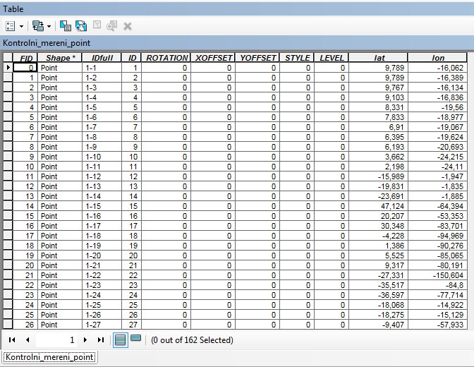
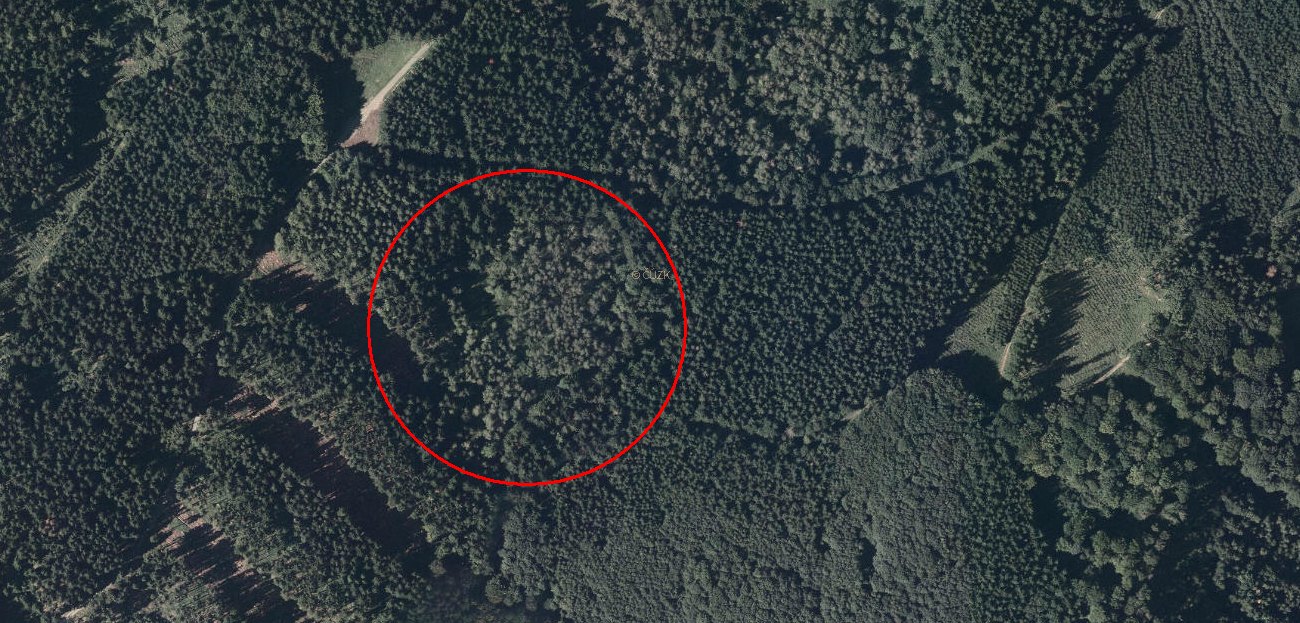
Now, I tried to calculate the x and y coords for my layer with set coord system for data frame as shown below but the point should, in my opinion, show in the red circle in the second image. To make everything clear I tried to join two attribute tables - the one of a shapefile and the other containing data for the points (exported database). However with no happy end except the join itself.
- Mark as New
- Bookmark
- Subscribe
- Mute
- Subscribe to RSS Feed
- Permalink
- Report Inappropriate Content
if you collected coordinates via a gps without changing the gps settings, then they should be in a WGS 84 coordinate system, however, it looks like you didnt clear out the waypoints prior to collecting the data and exporting the file since at least one of the coordinates is in a different hemisphere. I would revisit the procedure that you used to get the data into a shapefile before proceeding
- Mark as New
- Bookmark
- Subscribe
- Mute
- Subscribe to RSS Feed
- Permalink
- Report Inappropriate Content
Hello Anthony, thanks for your advice. I am no expert but from brief examining the spatial adjustment it seems, that I have to have some coordinate specific data to adjust anything, which I don't have. That is the problem. The set of points were not recorded in any coordinate system, they are only related to each other with x and y values (or z). And my question is, is there any way to give the the point the coords thus give whole bunch of point a coord system. But thank you anyway.
- Mark as New
- Bookmark
- Subscribe
- Mute
- Subscribe to RSS Feed
- Permalink
- Report Inappropriate Content
Lukas,
i thought you said that you had collected some control points using your gps. If so use the spatial adjustment to fix the points that have no location to those known points
- Mark as New
- Bookmark
- Subscribe
- Mute
- Subscribe to RSS Feed
- Permalink
- Report Inappropriate Content
Oh, well it's probably to late because that didn't occured to me  I'll extract those point out of gps unit and put them into Arcmap. I will keep you posted either to bother you all even more or to celebrate the success.
- Mark as New
- Bookmark
- Subscribe
- Mute
- Subscribe to RSS Feed
- Permalink
- Report Inappropriate Content
Hello Dan,
actually I collected the data with "fieldmap" containing only laser and compass but no gps unit. But as I heard that I possibly could "georeference" the points, I brought to the field my own gps. Yes, it gives the point WGS84 coords and I live in central Europe where a different CS is used (S-JTSK_Krovak_East_North).
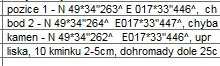
I tried to set the data frames' cs to WGS84 and recalculate alt and long for my point but it still don't match. Not to mention that I didn't get to doing anything with those two measured coords N 49°34'263"....