- Home
- :
- All Communities
- :
- Developers
- :
- Native Maps SDKs
- :
- .NET Maps SDK Questions
- :
- Problems with certain Vector Tile Basemaps in Runt...
- Subscribe to RSS Feed
- Mark Topic as New
- Mark Topic as Read
- Float this Topic for Current User
- Bookmark
- Subscribe
- Mute
- Printer Friendly Page
Problems with certain Vector Tile Basemaps in Runtime for .Net
- Mark as New
- Bookmark
- Subscribe
- Mute
- Subscribe to RSS Feed
- Permalink
- Report Inappropriate Content
There are a couple of vector tile basemaps that appear to have issues in Runtime (100.2 or 100.3), but work fine in ArcGIS Pro. The problem is that certain vector tile layers/basemaps with a little transparency show the blank, grey-gridded background behind them (see below.)
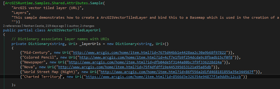
I am wanting to use the Charted Territory basemap in Runtime . I've modded your GITHUB sample (arcgis-runtime-samples) under 'Layers/ArcGisVectorTiledLayer' as shown below and the resulting image is also below. The same result occurs if I use the direct .json ref to the layer (https://www.arcgis.com/sharing/rest/content/items/1c365daf37a744fbad748b67aa69dac8/resources/styles/...)
Does anyone know any fixes for this?
Code mod:
Result:

- Mark as New
- Bookmark
- Subscribe
- Mute
- Subscribe to RSS Feed
- Permalink
- Report Inappropriate Content
The style has the country polygons authored with transparency. It's meant to be used as an overlay on top of a basemap to add the color to the underlying map. So what you're seeing is expected.
You can see that effect in the online viewer:
www.arcgis.com/home/webmap/viewer.html?useExisting=1&layers=8566d3e326354e94877f3a9dd9c12ccb
Try and open the above link and change the basemap and you'll see how it adds the color to the underlying basemap.
You can turn off the lines on the background grid on the MapView.BackgroundGrid property or add a basemap.
- Mark as New
- Bookmark
- Subscribe
- Mute
- Subscribe to RSS Feed
- Permalink
- Report Inappropriate Content
Thanks Morton. After my post i realized that the Pro and Runtime backgrounds defaulted differently (white vs grey with grid). I did not realize i could change that background and had overlooked that option to do so. Thanks!