- Home
- :
- All Communities
- :
- User Groups
- :
- New to GIS
- :
- Questions
- :
- Select by Location "remove from currently selected...
- Subscribe to RSS Feed
- Mark Topic as New
- Mark Topic as Read
- Float this Topic for Current User
- Bookmark
- Subscribe
- Mute
- Printer Friendly Page
Select by Location "remove from currently selected" versus Erase - different results. Why?
- Mark as New
- Bookmark
- Subscribe
- Mute
- Subscribe to RSS Feed
- Permalink
- Report Inappropriate Content
ArcGIS for Desktop 10.3.1
Source data: ESRI modules regarding Crater Lake (Spatial Analysis)
The objective of the analysis was to remove areas that are within 1 mile of a road, as to find suitable habitat for bald eagles that are under the trees and near water. Let's call the layer file for trees and water "trees" for simplicity.
Method 1 : Trees --> Select All --> Select by Location à Remove from current selection, those within 1 mile of roads (are within a distance of the source layer feature) à Result: a feature layer with 6774 rows, with a total area of ~8,000 acres
Method 2: Road à Create 1 mile buffer (Call this RoadBuffer). Erase (Trees, Road Buffer) à Result: a feature layer with 7097 rows, with a total area of ~20,000 acres
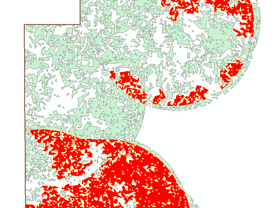
When I look at the images (I've attached a snapshot here), Method 2 results make sense. I am not quite sure how Method 1 is working, and Method 1 is actually what the ESRI virtual campus suggests.
How are these two functions implemented differently? The buffer/erase method I can easily understand, but how is select by location, remove ... implemented?
Thanks!
Solved! Go to Solution.
Accepted Solutions
- Mark as New
- Bookmark
- Subscribe
- Mute
- Subscribe to RSS Feed
- Permalink
- Report Inappropriate Content
When you do a spatial selection, the entire feature part gets selected (or deselected) even if a part of it would be in the given distance. So, when you are removing the features from the selected, many features (wholly) gets deselected.
On the other hand, when you use Erase, it "cuts-off" the features to the given distance only. It results in creation of many smaller polygons as well (thus, the large no. of polygons).
Spatial selection will let you select entire feature which satisfies the selection rule (you can not select a subset of it). On the contrary, Erase will cut off the exact area of the features including the subset of features.
Think Location
- Mark as New
- Bookmark
- Subscribe
- Mute
- Subscribe to RSS Feed
- Permalink
- Report Inappropriate Content
Thank you for the response. That was actually my first guess (after doing some reading), but then the difference was so large, and the selected areas so different it did not make sense. But now I am looking at the data more closely, and I think I did not understand that you can have a 'multi part' polygon. I assumed every row of the table would be a polygon, and then the next row another one physically right next to it. (I know the order of the rows doesn't matter, but I didn't get the idea that you can have a geographically split polygon).
The attached image is one row of the attribute table, or one polygon. So now I can understand why this large polygon did not get selected, as a small part of it is within the 1 mile range. So another question is then, is there a way from the attribute table to know if you have a multipart (spatially separated) polygon versus contiguous besides just looking at it?
By the way, if someone knows the team at ESRI that develops these training modules (which I generally think are very well done), perhaps they can send this thread to them. Because I think in the bald eagle example, the selection/remove areas method does not seem quite applicable, as it is leaving out many areas that a biologist would consider acceptable.
- Mark as New
- Bookmark
- Subscribe
- Mute
- Subscribe to RSS Feed
- Permalink
- Report Inappropriate Content
You could convert the multipart features to singlepart Multipart To Singlepart—Help | ArcGIS for Desktop
Think Location