- Home
- :
- All Communities
- :
- User Groups
- :
- Python Snippets
- :
- Questions
- :
- Re: Start and End Points of a line (Field Calculat...
- Subscribe to RSS Feed
- Mark Topic as New
- Mark Topic as Read
- Float this Topic for Current User
- Bookmark
- Subscribe
- Mute
- Printer Friendly Page
Start and End Points of a line (Field Calculator)
- Mark as New
- Bookmark
- Subscribe
- Mute
- Subscribe to RSS Feed
- Permalink
- Report Inappropriate Content
Hi,
I'm interested in calculating the start and end points of a line in the field calculator. I've researched several boards and I cannot come up with code that successfully calculates the geometry. Does anyone have any ideas? Thanks!
Solved! Go to Solution.
Accepted Solutions
- Mark as New
- Bookmark
- Subscribe
- Mute
- Subscribe to RSS Feed
- Permalink
- Report Inappropriate Content
This is an older thread, but since I just had to do this for one of my scripts, I thought I would share the code I used. In my case, I already created a fishnet, as polylines that are clipped by a study area, and then converted the "multipart" segments to "singlepart" (so each segment in separate) ...but it should be able to work with any line. I addfields called x1, y1, x2, y2 for my needs...but you can name whatever works for you.
fishnetFC =  r"C:\Prep.gdb\FishnetIntersect_L_single"

ptFields = [["X1", "!SHAPE.firstPoint.X!"], ["Y1", "!SHAPE.firstPoint.Y!"], ["X2", "!SHAPE.lastPoint.X!"], ["Y2", "!SHAPE.lastPoint.Y!"]]
for field in ptFields:
    print("adding field {0}...".format(field[0]))
    arcpy.AddField_management(fishnetFC, field[0], "DOUBLE", "", "", "", "", "NULLABLE", "NON_REQUIRED", "")
    print("  calcing field {0} to be {1}".format(field[0], field[1]))
    arcpy.CalculateField_management(fishnetFC, field[0], field[1], "PYTHON_9.3" )
In any case Jessica, you should mark helpful comments as such, and either mark this as "assumed answered" or the answer that best solved your issue.
- Mark as New
- Bookmark
- Subscribe
- Mute
- Subscribe to RSS Feed
- Permalink
- Report Inappropriate Content
It is built-in as a tool, open your table and check out Calculate field tool options, one of which allows you to calculate polyline properties
- Mark as New
- Bookmark
- Subscribe
- Mute
- Subscribe to RSS Feed
- Permalink
- Report Inappropriate Content
Hi Jessica,
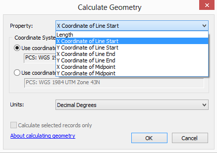
You could add a new field in attribute table and use Calculate Geometry to get the desired geometric properties.
Think Location
- Mark as New
- Bookmark
- Subscribe
- Mute
- Subscribe to RSS Feed
- Permalink
- Report Inappropriate Content
At 10.0 and above you have to use Python to do geometry calculations with the Field Calculator. The calculation to extract the Start point coordinates is:
!Shape.FirstPoint.X! (or Y, Z, or M)
The End point coordinates is similar:
!Shape.LastPoint.X! (or Y, Z or M)
See my responses in this thread for more geometry options.
- Mark as New
- Bookmark
- Subscribe
- Mute
- Subscribe to RSS Feed
- Permalink
- Report Inappropriate Content
This is an older thread, but since I just had to do this for one of my scripts, I thought I would share the code I used. In my case, I already created a fishnet, as polylines that are clipped by a study area, and then converted the "multipart" segments to "singlepart" (so each segment in separate) ...but it should be able to work with any line. I addfields called x1, y1, x2, y2 for my needs...but you can name whatever works for you.
fishnetFC =  r"C:\Prep.gdb\FishnetIntersect_L_single"

ptFields = [["X1", "!SHAPE.firstPoint.X!"], ["Y1", "!SHAPE.firstPoint.Y!"], ["X2", "!SHAPE.lastPoint.X!"], ["Y2", "!SHAPE.lastPoint.Y!"]]
for field in ptFields:
    print("adding field {0}...".format(field[0]))
    arcpy.AddField_management(fishnetFC, field[0], "DOUBLE", "", "", "", "", "NULLABLE", "NON_REQUIRED", "")
    print("  calcing field {0} to be {1}".format(field[0], field[1]))
    arcpy.CalculateField_management(fishnetFC, field[0], field[1], "PYTHON_9.3" )
In any case Jessica, you should mark helpful comments as such, and either mark this as "assumed answered" or the answer that best solved your issue.
- Mark as New
- Bookmark
- Subscribe
- Mute
- Subscribe to RSS Feed
- Permalink
- Report Inappropriate Content
I have marked the answer of Rebecca as the correct answer since it was place in Python snippets and code was requested, although the other answers are very good ones too, since you don't need code to do this.