- Home
- :
- All Communities
- :
- Industries
- :
- Transportation
- :
- Roads and Highways
- :
- Roads and Highways Questions
- :
- Re: ArcGIS Pro Coordinate System not projecting co...
- Subscribe to RSS Feed
- Mark Topic as New
- Mark Topic as Read
- Float this Topic for Current User
- Bookmark
- Subscribe
- Mute
- Printer Friendly Page
ArcGIS Pro Coordinate System not projecting correctly?
- Mark as New
- Bookmark
- Subscribe
- Mute
- Subscribe to RSS Feed
- Permalink
- Report Inappropriate Content
Hello everyone. This is my first time opening ArcGIS Pro, and already I see that our office data is not projecting correctly on the maps provided. I've checked the coordinate systems and they are correct, so I'm confused as to why it is doing this. (see below)

Any ideas?
- Mark as New
- Bookmark
- Subscribe
- Mute
- Subscribe to RSS Feed
- Permalink
- Report Inappropriate Content
Does this samIe data look different or "correct" in ArcMap? If the data looks fine in ArcMap, then something could be going on with Pro. If the data looks the same in ArcMap or you haven't tried it with ArcMap, then it could be a data issue as well.
- Mark as New
- Bookmark
- Subscribe
- Mute
- Subscribe to RSS Feed
- Permalink
- Report Inappropriate Content
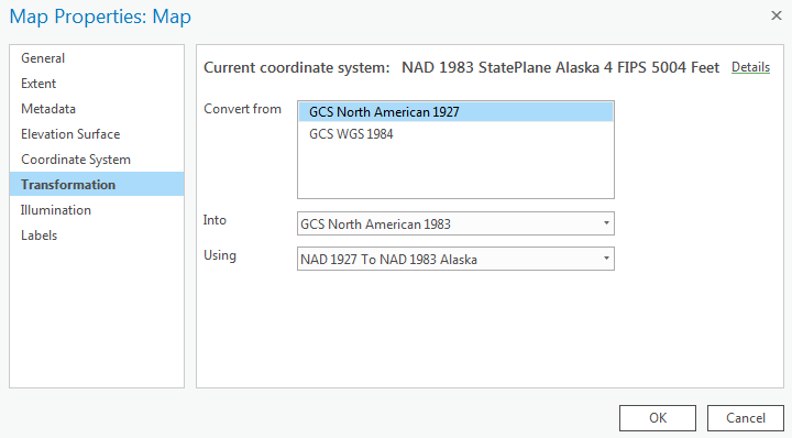
Do you have a geographic transformation error? Right click your Map View, select Transformation. Do you have multiple "convert from" GCS's listed? If so, you may need to set the Using dropdown to the correct method to resolve transformation error. Typically, it's the first one in the list.
- Mark as New
- Bookmark
- Subscribe
- Mute
- Subscribe to RSS Feed
- Permalink
- Report Inappropriate Content
This worked somewhat! But... It's still slightly of. Not as much as before, but enough to make map-building impossible with an aerial. I'm somewhat confused by the transformations. How they work. This is what my screen looks like:

And these are my options:
- Mark as New
- Bookmark
- Subscribe
- Mute
- Subscribe to RSS Feed
- Permalink
- Report Inappropriate Content
I just started putting in other shapefiles and some of them show up correctly, and some do not. I'll keep playing with it. But thank you for the transformations suggestion!
- Mark as New
- Bookmark
- Subscribe
- Mute
- Subscribe to RSS Feed
- Permalink
- Report Inappropriate Content
Presumably you're located in AK so the first transformation in the dropdown should be correct. Another thing that could shift the lines a bit if I you're using UTM and your data is close to a UTM Zone edge. Capture scale of the data could also explain it being off somewhat too. For example, the data was captured at 1:250,000 but you're zoomed into 1:24000.
Do you see the same data shift in ArcMap?
- Mark as New
- Bookmark
- Subscribe
- Mute
- Subscribe to RSS Feed
- Permalink
- Report Inappropriate Content
Check ArcMap and see what transformation (if any) is set there: Data frame properties, coordinate system tab, Transformations button. If it's not the same, change Pro to use the same transformation.