- Home
- :
- All Communities
- :
- User Groups
- :
- Roads and Highways User Group (RHUG)
- :
- Questions
- :
- Re: Calibrated Network Display Error
- Subscribe to RSS Feed
- Mark Topic as New
- Mark Topic as Read
- Float this Topic for Current User
- Bookmark
- Subscribe
- Mute
- Printer Friendly Page
Calibrated Network Display Error
- Mark as New
- Bookmark
- Subscribe
- Mute
- Subscribe to RSS Feed
- Permalink
- Report Inappropriate Content
Hello,
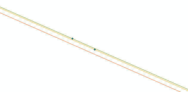
I've created a calibrated network which appears to be calibrated correctly, but I can see that the routes are misaligned around the calibration points (which were created from the same source dataset). Now, this is at 1:0.01 scale so the difference is microscopic, and it doesn't seem to have an practical impacts (translate lrm to lrm had no issues) but it is visually noticeable when zoomed out further.
Is this simply a display issue due to precision limits (the points are 0.2mm apart)? By definition the routes share the centreline so I figure it must be, but if this were any other dataset I would assume they weren't perfectly coincident.
Has anyone run into this before? Is this something to be concerned about?
Red = Centreline
Orange= Network 1
Green = Network 2
Thanks
- Mark as New
- Bookmark
- Subscribe
- Mute
- Subscribe to RSS Feed
- Permalink
- Report Inappropriate Content
Hi Colin,
What's the M tolerance for your network feature class? If the distance between the centerline and network features is less than the M tolerance, ArcGIS and Roads and Highways consider them to be coincident and in the same location. This is why LRM to LRM and other tools will still work as expected.
If the distance between the centerline and network features is greater than the M tolerance, you can run the Generate Routes tool to rebuild the route shapes to align with the centerline they're built from.
Nathan
Esri Roads and Highways team
- Mark as New
- Bookmark
- Subscribe
- Mute
- Subscribe to RSS Feed
- Permalink
- Report Inappropriate Content
Colin,
I have seen that before, however our calibration points where further off the centerline then the tolerance and submitted a ticket in the past for it. As explained to us, in a number of cases you can just delete the calibration points. As I recall these was an issue with pre 10.5.1 versions of the software.
To me maybe more concerning is centerline and milepoint are not coincident. It appears that someone has probably deleted some vertexes that where probably within tolerance and while they did probably run apply updates, it did not translate to milepoint so you have mismatch of vertexes on centerline and milepoint. I have found a cartographic realignment more then tolerance can fix the issue or if you are already running Generate Routes on the those that should fix the issue.
I would test on a non production dataset and run Generate Routes with all concurrent routes otherwise you may run into an issue of duplicated centerlines. You can run the deduplicate tool but that also has it's own issues.
Removing duplicate centerline geometry—Roads and Highways Desktop | ArcGIS Desktop
Main one I recall from 2017 is unexpected event behaviors. Not sure if it changed the event measures or the values either way some events did not appear the same before and after.
- Mark as New
- Bookmark
- Subscribe
- Mute
- Subscribe to RSS Feed
- Permalink
- Report Inappropriate Content
The centreline and milepoint not being coincident is the crux of the issue. When I created and loaded the network it matches, and the uncalibrated network also matches the centreline. When I add the set of milepoints and apply updates, that's when the lines visually change to go through the points, rather than the points being on the line.
They ARE all within the M tolerance though (1mm), which is why I was asking if anyone has seen this particular issue before. I feel like it would be somewhat common experience if Roads and highways applies the points to anywhere within that tolerance.
This testing seems to have broken the centreline feature class, so I'll have to recreate it to test the cartographic realignment suggestion. Additionally no one else is doing any editing or anything in this environment.
It could potentially be related to how I bulk added the calibration points in the first place. Stay tuned for my upcoming question on that topic.
- Mark as New
- Bookmark
- Subscribe
- Mute
- Subscribe to RSS Feed
- Permalink
- Report Inappropriate Content
On further inspection it's only happening on two routes out of ~15. Could it be related to the geometry of the centreline somehow?
Currently getting access to data reviewer so I can take a look.
- Mark as New
- Bookmark
- Subscribe
- Mute
- Subscribe to RSS Feed
- Permalink
- Report Inappropriate Content
I am not going to say it cannot be but I have not seen that be an issue unless it was something unsupported like lollipop, alpha route, etc.
- Mark as New
- Bookmark
- Subscribe
- Mute
- Subscribe to RSS Feed
- Permalink
- Report Inappropriate Content
Hi Colin,
Is this reproducible on a new map document? I've seen this occur sometimes when the same map document is used for a longer period of time.
- Mark as New
- Bookmark
- Subscribe
- Mute
- Subscribe to RSS Feed
- Permalink
- Report Inappropriate Content
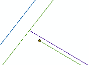
Yes it's reproducible, I usually open new document's every time. It's also the same locations as far as I can tell. I did find a new use case, where it's occurring at the junction of two routes. It's fine at the calibration points on either side and the centreline junction is coincident in the case below (though there are also cases where they are not). There are no issues in the database where the second calibrated network has not been created.
Again, these errors are all within tolerance, but I'm seeing the below issue on two additional calibrated routes.
- Mark as New
- Bookmark
- Subscribe
- Mute
- Subscribe to RSS Feed
- Permalink
- Report Inappropriate Content
I would not lose sleep over this. ArcGIS treats points/vertices within the XY tolerance as as the same location. It is discussed in the "Tolerance" section on this page: Defining feature class properties—ArcGIS Help | Documentation
- Mark as New
- Bookmark
- Subscribe
- Mute
- Subscribe to RSS Feed
- Permalink
- Report Inappropriate Content
I asked here specifically because I would expect it to be common behaviour if it's a tolerance issue and wanted to know if others experience the same thing in their ALRS. And why only certain routes and locations?
Like I said, I wouldn't have given it a second thought if it were a regular feature class/gdb.
That said, I 100% agree it's not a practical issue and consider this closed.