- Home
- :
- All Communities
- :
- Products
- :
- Spatial Data Science
- :
- Spatial Data Science Questions
- :
- Re: Measuring area of raster classes
- Subscribe to RSS Feed
- Mark Topic as New
- Mark Topic as Read
- Float this Topic for Current User
- Bookmark
- Subscribe
- Mute
- Printer Friendly Page
- Mark as New
- Bookmark
- Subscribe
- Mute
- Subscribe to RSS Feed
- Permalink
- Report Inappropriate Content
Hi, i have a raster in which the values represent soil loss (t h-1 y-1) would like to find the area of each class in hectares, but i am unsure of the calculation.
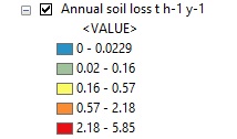
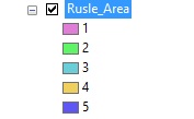
I have reclassified them with the same classes.
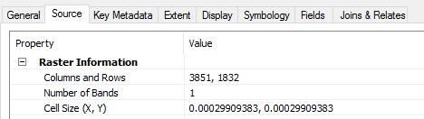
The raster properties are as follows:
Attribute table:
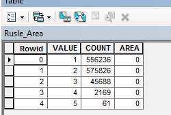
The units are in meters (OSGB 1936). using this cell size does 1 pixel therefore represent 0.00029 hectares in this case? (1 sq m = 0.0001 hectares). So 556,236 x 0.00029 = 161.3 hecatres sq - does that seem correct?
Thanks
Solved! Go to Solution.
Accepted Solutions
- Mark as New
- Bookmark
- Subscribe
- Mute
- Subscribe to RSS Feed
- Permalink
- Report Inappropriate Content
If your map units are truly in meters then your raster size is only 1.15m x 0.55m. Does that seem right?
I would suggest to redo your analysis in a data frame with a true meter system as coordinate system. Also check in your processing environment settings that the output coordinates are in a meters system. Then you could indeed calculate the area per raster class as number of cells x cell size x cell size, which would give you a result in square meters. Divide by 100 x 100 (10,000) to get hectares.
- Mark as New
- Bookmark
- Subscribe
- Mute
- Subscribe to RSS Feed
- Permalink
- Report Inappropriate Content
Re-done the analysis in British National Grid (OSGB 1936), seems to have worked. Thanks.
- Mark as New
- Bookmark
- Subscribe
- Mute
- Subscribe to RSS Feed
- Permalink
- Report Inappropriate Content
Your original was in decimal degrees I suspect, projecting the raster I assume, gives you the correct units
- Mark as New
- Bookmark
- Subscribe
- Mute
- Subscribe to RSS Feed
- Permalink
- Report Inappropriate Content
Yes, you should check your coordinate system and units before calculate the area.
Make sure that your coordinate system is projected, and your units are in meter not in decimal degree, M S.