- Home
- :
- All Communities
- :
- Industries
- :
- State & Local Government
- :
- State & Local Government Questions
- :
- Re: How do you organize your City data?
- Subscribe to RSS Feed
- Mark Topic as New
- Mark Topic as Read
- Float this Topic for Current User
- Bookmark
- Subscribe
- Mute
- Printer Friendly Page
How do you organize your City data?
- Mark as New
- Bookmark
- Subscribe
- Mute
- Subscribe to RSS Feed
- Permalink
- Report Inappropriate Content
I am looking for sample geodatabase schemas for Cities. I am reorganizing our gis data as we move to enterprise. I haven't found any documentation with suggested organization. I have looked at the local government information model, but this doesn't work. It is difficult to work with and manage data when it is contained in one geodatabase. I am considering using workflow and data reviewer so I know there are some considerations for these.
Below are some questions for those that manage City data:
What feature classes are considered authoritative for Cities? I have seen lists for States but nothing for Cities. Or I am looking in the wrong place.
Do you use separate geodatabases for different functions ie. water, wastewater, parks and rec, fire, police?
In your geodatabases do you use feature datasets?
How do you manage reference data? Do you push it to portal?
Do you use a staging server and a production server?
I am very interested in snapshots of how your data is organized.
thanks
- Mark as New
- Bookmark
- Subscribe
- Mute
- Subscribe to RSS Feed
- Permalink
- Report Inappropriate Content
Did you find a path forward? I just saw this, and would be happy to share my schema. I hated the localgov model, so I created my own. How things are organized could depend on what your main data silos are, though, along with how they are used.
- Mark as New
- Bookmark
- Subscribe
- Mute
- Subscribe to RSS Feed
- Permalink
- Report Inappropriate Content
Dan,
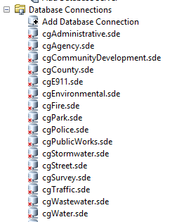
I punted. I thought this might a question that a lot of us are struggling with - not so much. I also didn't like the local government model. If I have do any thing to one area of data it affects everything. What I ended up doing is geodatabases per division ie public works, community development and also utilities ie water, wastewater, stormwater, transportation. They all sit on the same server and instance of sql. I don't do replication or currently have a test site. I need get that up and testing. Secondary programs that attach limit how that can work. I am including a screenshot of how I set it up. Now I would like to work on creating some basic data schemas to share with folks that are in cities - seems to be a big hole. I also included a screenshot of wastewater - the Assets and AssetsNz are for grouping those assets that are z and m aware and are used with an arrow receiver for high accuracy data collection in collector. And so that I can set up some topologies for QA/QC

- Mark as New
- Bookmark
- Subscribe
- Mute
- Subscribe to RSS Feed
- Permalink
- Report Inappropriate Content
Yes, I would like to see your organizational structure.
- Mark as New
- Bookmark
- Subscribe
- Mute
- Subscribe to RSS Feed
- Permalink
- Report Inappropriate Content
Not sure if you are still active on these forums, but if so, I'd love to see your schema if you are still willing to share it. We are working on transitioning from a veritable ocean of shapefiles to something hopefully more organized and easier to manage.