- Home
- :
- All Communities
- :
- User Groups
- :
- Training in GIS
- :
- Questions
- :
- Will not georectify
- Subscribe to RSS Feed
- Mark Topic as New
- Mark Topic as Read
- Float this Topic for Current User
- Bookmark
- Subscribe
- Mute
- Printer Friendly Page
- Mark as New
- Bookmark
- Subscribe
- Mute
- Subscribe to RSS Feed
- Permalink
- Report Inappropriate Content
I have put the georeferenced control points onto my target layer (scanned image in jpg format), the Total RMS Error is 0.813546 with four links. It is linked to an ortho raster image. BUT, it will not let me rectify. In the save as dialog, I leave alone the cell size, noData as, the resample type (nearest neighbor). When I try to enter the output location, it cannot be entered. No matter what kind of folder I try to save it in, it tells me that 'object not found' and I cannot change the show of type. What am I doing wrong?
Thanks
Jill
Solved! Go to Solution.
Accepted Solutions
- Mark as New
- Bookmark
- Subscribe
- Mute
- Subscribe to RSS Feed
- Permalink
- Report Inappropriate Content
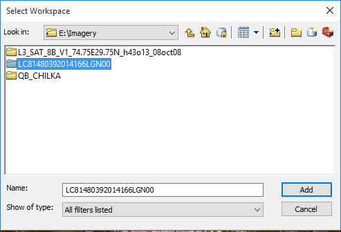
In Output Location option, you should select a basic folder / Geodatabase and click ADD. Do not enter any FileName in it.
Think Location
- Mark as New
- Bookmark
- Subscribe
- Mute
- Subscribe to RSS Feed
- Permalink
- Report Inappropriate Content
You have 4 points, but you specify what order of rectification you are using, I am wondering if is a simple as not enough points for the type chosen
Fundamentals of georeferencing a raster dataset—Help | ArcGIS for Desktop
- Mark as New
- Bookmark
- Subscribe
- Mute
- Subscribe to RSS Feed
- Permalink
- Report Inappropriate Content
It is a 1st order polynomial and it did not help adding more points.
- Mark as New
- Bookmark
- Subscribe
- Mute
- Subscribe to RSS Feed
- Permalink
- Report Inappropriate Content
To expand on what Dan Patterson pointed out, from the link he posted:
The number of the noncorrelated control points required for this method must be 1 for a zero-order shift, 3 for a first order affine, 6 for a second order, and 10 for a third order.
Chris Donohue, GISP
- Mark as New
- Bookmark
- Subscribe
- Mute
- Subscribe to RSS Feed
- Permalink
- Report Inappropriate Content
In Output Location option, you should select a basic folder / Geodatabase and click ADD. Do not enter any FileName in it.
Think Location
- Mark as New
- Bookmark
- Subscribe
- Mute
- Subscribe to RSS Feed
- Permalink
- Report Inappropriate Content
Thanks for your suggestion. I was trying to save it in my geodatabase folders, instead of regular folders. Once I was putting the output files in a regular folder, I could then choose the type of image file to save, and it worked.