- Home
- :
- All Communities
- :
- Industries
- :
- Water Resources
- :
- Water Resources Questions
- :
- Re: ArcHydro Problem Solvers
- Subscribe to RSS Feed
- Mark Topic as New
- Mark Topic as Read
- Float this Topic for Current User
- Bookmark
- Subscribe
- Mute
- Printer Friendly Page
- Mark as New
- Bookmark
- Subscribe
- Mute
- Subscribe to RSS Feed
- Permalink
- Report Inappropriate Content
- Make sure the Geoprocessing extents include the whole project: Go to the Geoprocessing menu>Environments...>Processing Extent. Under Processing Extent choose a layer that you know covers the full extent of the waters you are processing and click OK. This should ensure that the processing extent is large enough to do what you want.
- Delete everything you can in your temp folder: Mine is C:\Users\mboucher\AppData\Local\Temp. Get out of ArcMap first to clear temp files related to your project. You can do this without getting out of ArcMap through the ArcHydro Toolbar under ApUtilities>Additional Utilities>Clean User's Temp Folder.
- Make sure your Target Locations are correct: Under ApUtilities>Set Target Locations, make sure the HydroConfig and they GeoHMSConfig Targets make sense. The raster data should go to the project folder vector data to a geodatabase. The raster data will go to a folder in the project folder with the dataframe name and the vector data to a feature data set with the dataframe name. Through the ArcHydro Toolbar under there is a function to reset the target locations: ApUtilities>Additional Utilities>Reset Target Locations. I've not tested this to see if it corrects everything.
- When working on a complicated model, don't use the model mxd for your presentation map. It just adds baggage to an already "heavy" mxd.
Solved! Go to Solution.
- Mark as New
- Bookmark
- Subscribe
- Mute
- Subscribe to RSS Feed
- Permalink
- Report Inappropriate Content
My most recent discovery is more generally related to geoprocessing and is not specific to Arc Hydro. However, since Arc Hydro is heavy on geoprocessing, I wanted to post this here.
My latest Arc Hydro project had ArcMap freezing up when saving and at other times. I'd have to wait forever or, out of impatient frustration, I would "X" out and/or cancel it using Task Manager. Then I heard about something in the geoprocessing options that seems to have put and end to that!
- Under the menu Geoprocessing chose Geoprocessing Options.
- On the Geoprocessing Options window change the "Keep results younger than:" to something low.
- I have mine set a 1 day. It might have been set a 2 months.
- This reduces the amount of results that are shown on the Results tab you get under the Geoprocessing>Results menu item.
This seems to make saving much, much faster and I haven't had it crash yet. 
Hope this tip helps!
Mark
- Mark as New
- Bookmark
- Subscribe
- Mute
- Subscribe to RSS Feed
- Permalink
- Report Inappropriate Content
I am using arc hydro 10.1 and there are some solutions to these error which works for me
- define workspace location and processing extent in c drive
- Whenever you have to use arc hydro, always define a geodatabase then start using the tool
- always delete the temp files.
May be this will help.
- Mark as New
- Bookmark
- Subscribe
- Mute
- Subscribe to RSS Feed
- Permalink
- Report Inappropriate Content
Hello!
I have a problem when calculating the Longest Flowpath using HEC-GeoHMS.
It turns out that the program starts to compile, stays for more than 20 minutes calculating, after that the program is closed, I open it again and all the progress of the Longest flowpath calculation is lost.
I have tried deleting the temporary files, changing the location of the files and everything said above.
I need if someone can help me with this problem please.
Thanks
- Mark as New
- Bookmark
- Subscribe
- Mute
- Subscribe to RSS Feed
- Permalink
- Report Inappropriate Content
This is an excellent Arc Hydro thread that I've depended on throughout my Arc Hydro experience.
Has anyone had success using Arc Hydro for ArcGIS Pro for stormwater workflows? I'm trying to take into consideration streets and drainage networks for watershed delineation, like I've done in ArcMap 10.5 and 10.6. Unfortunately, I'm encountering a lot of problems including ERROR 999999 and Failed to Execute EucAllocation.
I’ve tried re-organizing my data and troubleshooting different ways as well per other stratgies I've learned with ArcMap but to no avail. Perhaps they still need to work out some bugs or revert back to Target Location folders?
You help's much appreciated!
#archydrotools, #archydro drainage delineation, #archydro tools
- Mark as New
- Bookmark
- Subscribe
- Mute
- Subscribe to RSS Feed
- Permalink
- Report Inappropriate Content
Sorry. I haven't had the opportunity to use ArcGIS Pro.
Mark
- Mark as New
- Bookmark
- Subscribe
- Mute
- Subscribe to RSS Feed
- Permalink
- Report Inappropriate Content
Hi all,
I am having difficulty running Evaluate Depressions on a 1600x2500 grid in 32-bit integer centimetres. I have also tried 16-bit but it still hangs at the same point (Computing drainage area for depressions...).
It runs fine on floating point grid but it is slow (4 hours) so I was hoping that it would be faster for integer grids.
I would like to know:
If anyone has successfully Evaluated Depressions on an integer grid of such a size?
Has anyone noticed significant performance improvement on integer grids compared to floating point?
Thanks! Garret
- Mark as New
- Bookmark
- Subscribe
- Mute
- Subscribe to RSS Feed
- Permalink
- Report Inappropriate Content
I haven't used that tool. Running the project on the local C: drive does speed processing up quite a bit. If you aren't doing that, you may want to try it.
Best,
Mark
- Mark as New
- Bookmark
- Subscribe
- Mute
- Subscribe to RSS Feed
- Permalink
- Report Inappropriate Content
Hi Mark,
Just closing off this issue. "Evaluate Depressions" hadn't been 'migrated' to Python. It has been now thanks to Christine in ESRI and python version works much faster now even with float raster. See the thread.
Garret
- Mark as New
- Bookmark
- Subscribe
- Mute
- Subscribe to RSS Feed
- Permalink
- Report Inappropriate Content
I felt that after so much research and frustration, I needed to share my findings regarding an error that kept showing when I used the Sink Evaluation tool (see image)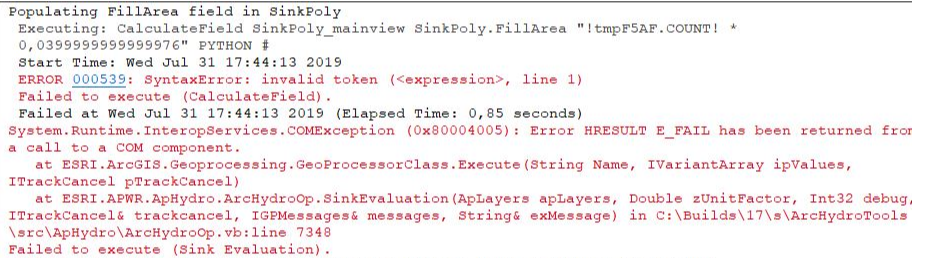
It turns out that my system decimal symbol was set to "," instead of "." which caused the Field Calculator to interrupt the process and trigger the COM component error. This might be more useful for the French community but anyhow, I think it's good to be put out there.
- Mark as New
- Bookmark
- Subscribe
- Mute
- Subscribe to RSS Feed
- Permalink
- Report Inappropriate Content
My team has been working with ArcHydro tools for a long while, and our team leader, a black belt in Python scripting, created a script that would do what GeoHMS did, so that our engineers wouldn't have to go through all of the Arc Pre-Processing steps individually. Lately we've been getting "MemoryError" issues, even on small basins. The only things that have changed in the script are minor tweaks to make the process faster.
On my computer, the process seems to get stuck at the Compute Basins, Reaches, and Nodes section, but the errors come at other places on other machines.
I've set extents, cleared the temp folder, and turned off background geoprocessing, but still am getting the error. Any ideas on where to go next?
You've been a great help on here, so I thought I'd ask the expert before calling Esri!
Annina