- Home
- :
- All Communities
- :
- Industries
- :
- Water Utilities
- :
- Water Utilities Questions
- :
- Re: Water Utility Editing Tools - "Add Laterals Fr...
- Subscribe to RSS Feed
- Mark Topic as New
- Mark Topic as Read
- Float this Topic for Current User
- Bookmark
- Subscribe
- Mute
- Printer Friendly Page
Water Utility Editing Tools - "Add Laterals From Line Locations" Help
- Mark as New
- Bookmark
- Subscribe
- Mute
- Subscribe to RSS Feed
- Permalink
- Report Inappropriate Content
Hello Everyone!
I am currently in the last few weeks of my internship with a GIS city group, my supervisor has introduced me to the Water Utility Editing Tools and its features. I have been tweaking the config file to match our layer names and everything, but cannot get the "Add Laterals From Line Locations" tool to work properly. When I select a water meter and the main water line, the tool will run and produce a connecting line that only makes it roughly halfway to the main line. Here are a couple of images to hopefully clear any confusion:
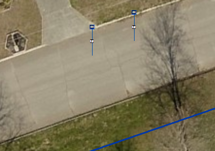
Here you can see two test water meters with a mainline across the street:

After selecting BOTH the meter and the main line, I am given this after running the "Add Laterals From Line Locations" Tool:
I am curious if anyone has encountered this problem before and/or might be able to give me insight to a solution?! Any help would be greatly appreciated and let me know if you need me to provide any more information such as the Config file I have setup.
Thanks ahead of time!
- Mark as New
- Bookmark
- Subscribe
- Mute
- Subscribe to RSS Feed
- Permalink
- Report Inappropriate Content
Devin, I'm guessing you've moved on in your career at this point, but I thought I would chime in with a simple observation:
It appears you have the config file set to connect laterals to the nearest street center line, instead of the nearest water main line. Or maybe the location of the corp stop is set to be the street center line, and the lateral is not extending from there?
I'm about to set this up for our District as well, and will report back if I see similar unexpected behavior.
- Mark as New
- Bookmark
- Subscribe
- Mute
- Subscribe to RSS Feed
- Permalink
- Report Inappropriate Content
How does one get to this config file and edit it?
- Mark as New
- Bookmark
- Subscribe
- Mute
- Subscribe to RSS Feed
- Permalink
- Report Inappropriate Content
After you've followed the instructions to install the Water Utility Editing Toolbar found here : Water Utility Network Editing and Analysis | ArcGIS for Water , click the tool on the far right of the Attribute Assistant Toolbar called "Show Config Information" (the symbol is a document sheet with a cog in front of it). This will open the Config and Log File Dialog Window. Click on Config File Path > Open Location, which will open the folder where your config file has been saved locally. Open the "loaded.water.config" file with a text editor. Notepad++ works well (and is a free download). I recommend you make a copy of the original before altering the file. After you've made changes and saved (using the same naming convention as the original), you may have to re-launch ArcMap. The Reload button on the Config and Log File Dialog may only reload the Attribute Assistant config file.
Specifically regarding the above lateral creation configuration, here is the section of the config file to look at:
<!-- Begin Configuration Section for the Add Laterals Tool and Construction Tools, This is an XML array, so you can define any number of AddLateralDetails Entities-->
<AddLateralsLayers>
<!-- Start of the Entry, the name is just for reference, not used or presented-->
<AddLateralDetails Name="Meters to Mains">
<!-- The Point layer to connect to the main through a lateral-->
<Point_LayerName>Water Service Connections</Point_LayerName>
<!-- the layer to look to connect to, the lateral will connect
to this from the point-->
<MainLine_LayerName>Water Mains</MainLine_LayerName>
<!-- The line used to connect the point to the main-->
<LateralLine_LayerName>Water Lateral Lines</LateralLine_LayerName>
<!-- The Template to use to populate the attributes of the lateral line,
this can be removed or left blank and the user will be prompt for a template-->
<LateralLine_EditTemplate>1" Copper Domestic</LateralLine_EditTemplate>
Another possibility for why Devin was getting the behavior in the original post could be because of the way his organization was treating abandoned or removed Main Lines. If they were perhaps changing an attribute in the feature class which then drew the lines with blank symbology, it could have been that the lateral construction tool was treating un-symbolized abandoned lines as the nearest main line.
I had to get around this in our District by setting a definition query on the wMainLines feature class of "LifecycleStatus <> Abandoned" before running the tool. If you are strictly following the LGIM, your abandoned lines will be in a separate feature class and not be an issue. However, we couldn't get the abandon features tool to work properly, and I didn't like that I was losing a lot of attributes when these lines were abandoned. So we added a LifecycleStatus field and AbandonedDate field to each feature class instead.
- Mark as New
- Bookmark
- Subscribe
- Mute
- Subscribe to RSS Feed
- Permalink
- Report Inappropriate Content
And this will change for example... I have a service line being generated with a generate service tool (just creates a service line from a meter to the closest main - tool is from the Gas Utility Network Tools Addin ), but it automatically includes an excess flow valve 10ft from the tap. Since we have just recently started tracking excess flow valves we have no way to know that one was installed and do not want them included unless we manually place one. I am interested to see if this is controlled by the config file you have referenced.
- Mark as New
- Bookmark
- Subscribe
- Mute
- Subscribe to RSS Feed
- Permalink
- Report Inappropriate Content
Yep, that’s in there too. Just scroll through and you will find it. I had to do the same thing to remove curb stops from being automatically created on laterals.
-Joe Bryant
- Mark as New
- Bookmark
- Subscribe
- Mute
- Subscribe to RSS Feed
- Permalink
- Report Inappropriate Content
Or even simpler now that I re-read the original post: are you selecting the meters and the main at the same time using the selection tool? The un-symbolized street center line is getting selected too by your bounding box. Since it is the nearest line, that is where the laterals terminate.
- Mark as New
- Bookmark
- Subscribe
- Mute
- Subscribe to RSS Feed
- Permalink
- Report Inappropriate Content
Joe - I am working on a similar process, where I would like the line to draw from the curb stop valve (not the service connection) to the main.
Would I simply make the following changes (bold😞
<!-- Begin Configuration Section for the Add Laterals Tool and Construction Tools, This is an XML array, so you can define any number of AddLateralDetails Entities-->
<AddLateralsLayers>
<!-- Start of the Entry, the name is just for reference, not used or presented-->
<AddLateralDetails Name="Curb Stop Valves to Mains">
<!-- The Point layer to connect to the main through a lateral-->
<Point_LayerName>Water Curb Stop Valves</Point_LayerName>
<!-- the layer to look to connect to, the lateral will connect to this from the point-->
<MainLine_LayerName>Water Mains</MainLine_LayerName>
<!-- The line used to connect the point to the main-->
<LateralLine_LayerName>Water Lateral Lines</LateralLine_LayerName>
<!-- The Template to use to populate the attributes of the lateral line, this can be removed or left blank and the user will be prompt for a template-->
<LateralLine_EditTemplate>1" Copper Domestic</LateralLine_EditTemplate>
And then just cut out the following section?:
<!-- This section allows you to create a series of points along the main, it can be removed-->
<PointsAlong>
<!-- The entry for one point-->
<PointAlong>
<!-- The name of the layer to place, this must match the layer name in the TOC-->
<LayerName>Water Curb Stop Valves</LayerName>
<!-- The distance to place along the lateral, percent or feature units-->
<Distance>5</Distance>
<!-- Determines if the distance above is percent or feature units-->
<DistanceIsPercent>false</DistanceIsPercent>
<!-- The editor template used to fill in the attributes, this can be removed or left blank and the user will be prompted for a template-->
<EditTemplate>Roundway</EditTemplate>
<!--Option to intersect a polygon layer and offset the point from the intersection point on the polygon boundary-->
<PolygonOffsetLayerName>OwnerParcel</PolygonOffsetLayerName>
<!--To or the From Side of the intersection, the digitized direction of the lateral matters: Options - To or From-->
<PolygonOffsetSide>From</PolygonOffsetSide>
<!-- Option to split the lateral at the intersection -->
<SplitLateral>false</SplitLateral>
<!-- ends this layer's configuration-->
any help would be appreciated.
thanks,
- Mark as New
- Bookmark
- Subscribe
- Mute
- Subscribe to RSS Feed
- Permalink
- Report Inappropriate Content
Greg - that looks right. The <Point_LayerName> is based on the the name of the layer in your table of contents in your MXD, so I cannot confirm for you that is the correct name.
As far as removing the points along a line, you can just remove the layer name from in-between the argument brackets instead of the whole statement. That way it is easy to reconstruct in the future if you ever want to use it. It won't cause an error when missing the variable.
Hope this makes sense (I am in no way an expert)!
- Mark as New
- Bookmark
- Subscribe
- Mute
- Subscribe to RSS Feed
- Permalink
- Report Inappropriate Content
Couple follow-up questions on this old thread.
1. After installing the add-ins, I only see the "loaded.aa.config" file. I assume there are supposed to be at least a couple config files installed?
2. I'm playing around with this tool to create laterals between two layers, water lines and service points. Both these layer have a common attribute. Is it possible to configure this tool to use common attributes to draw laterals? For example, if pipe 1 has an ID of 100 and service point 2 has an ID of 100, then draw a lateral between these two features.