- Home
- :
- All Communities
- :
- Products
- :
- Spatial Data Science
- :
- Spatial Data Science Questions
- :
- How to determine if a line is on the boundary of t...
- Subscribe to RSS Feed
- Mark Topic as New
- Mark Topic as Read
- Float this Topic for Current User
- Bookmark
- Subscribe
- Mute
- Printer Friendly Page
How to determine if a line is on the boundary of two polygons
- Mark as New
- Bookmark
- Subscribe
- Mute
- Subscribe to RSS Feed
- Permalink
- Report Inappropriate Content
Hello,
I need to figure out a way to determine if a line is along a boundary of two polygons.
If the line is on the boundary, or within a tolerance of the actual boundary line, then I will need to credit each of the polygons by 50% of the length. If the line runs through a polygon then that polygon will get 100% of the credit for the portion of line.
How can I do this in ArcGIS Advanced?
Thanks
- Mark as New
- Bookmark
- Subscribe
- Mute
- Subscribe to RSS Feed
- Permalink
- Report Inappropriate Content
It's interesting that you are tackling this - I have a somewhat similar task on my "to do" list at this very moment in trying to update our City's Land Use layer versus the Parcels.
Some basic ideas that I am toying with (as yet untested for this specific task):
1. Convert your parcels from polygons to lines, then do a Spatial Join of your boundary line to the polygon line.
2. Run a Select By Location to determine the relationships.
Chris Donohue, GISP
- Mark as New
- Bookmark
- Subscribe
- Mute
- Subscribe to RSS Feed
- Permalink
- Report Inappropriate Content
Chris and others,
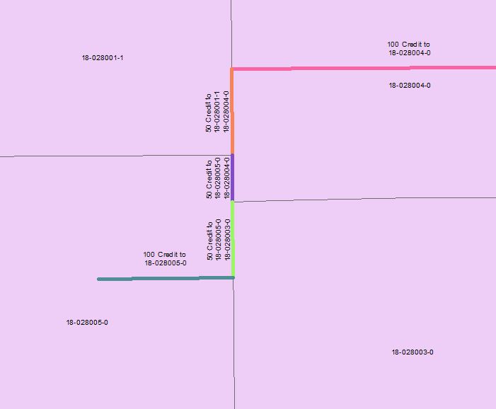
If the topology between the line and polygon features were perfect, that would work. However, the problem I face is that the data is originating from two different sources. If the line is off from the polygon boundary by up to 25 feet or so I still want to consider that line as “running along the boundary.”
The first thing that came to mind was that I could buffer polygon boundaries. The purple line would correctly be located within the buffered 18-028005-0 polygon, and the buffered 18-028004-0 polygon. However, a fraction of the endpoints would also be located within the 18-028001-1, and 18-028003-0 polygon. I am not really sure how to deal with a tolerance.
Thanks
Sincerely,
Mark Volz, GISP
- Mark as New
- Bookmark
- Subscribe
- Mute
- Subscribe to RSS Feed
- Permalink
- Report Inappropriate Content
Another idea - not a complete solution but may help fill in some pieces to the puzzle. I.e. some food for thought:
1. Split the line by the Parcels
2. Convert the line to point at the center
3. Run "Near" with a Searchdistance of 25ft. May have to use the bearing information to avoid capturing a non-participating parcel at a right-angle crossing at a 4-way parcel intersection.
Near
One immediate pitfall, though, is that the line may not be split often enough. For example, if it travels to 20 feet to the "West" side of parcel 18-028005-0 it will not be split enough to capture the two parcels to the "East".
Chris Donohue, GISP