ArcGIS Drone2Map Blog

cancel
Showing results for 
Show  only  | Search instead for 
Did you mean: 

Other Boards in This Place


Latest Activity

(8 Posts)
CodyBenkelman
Esri Regular Contributor

ArcGIS Drone2Map version 2024.1 has been released!  The latest version is now available for users to download from My Esri.  

This blog contains some highlights for what’s new in this version.   For a complete list of everything new or improved, please check our help documentation.

Further improvements in the quality in the 3D mesh, especially for thin structures

With every release, Esri works hard to improve processing efficiency and the quality of the output data products.  In 2024.1, our users will be able to reproduce thin structures like antennas, towers and bridges with better fidelity than ever before in the 3D mesh as well as 3D point cloud.  The structural improvements will also be noticeable along sharp building edges. 
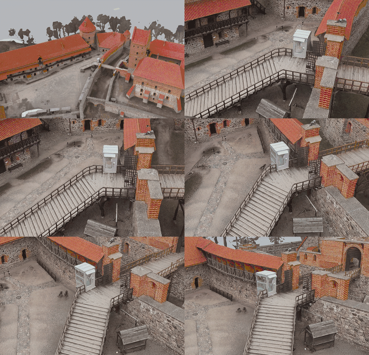
 

TrakuPilis_staircase_zoom_600x400.gif

In this release, be sure to use the “ultra” setting for the point cloud density for best resolution in the 3D mesh.

CodyBenkelman_11-1715373891583.png


Enhancements to the Inspection workflow

The 3D Inspection workflow, new at version 2023.2, has now been improved regarding the accuracy of inspection features created in 3D space through multisketch editing.  After the image adjustment has been run, when users draw a sketch on multiple images, Drone2Map will automatically correlate between images to improve the accuracy of the 3D features.  

CodyBenkelman_13-1715374119670.png

We’ve also enabled faster access to the inspection workflow.  The full 3D editing capabilities of an inspection session will require that the block adjustment step has been completed, but for time critical image inspections, users can now perform an inspection without running any processing – simply create the project and proceed immediately to inspection.  In this rapid workflow, the observations cannot be placed into 3D space, but users can review the drone imagery and generate a report in a matter of minutes.

Catalog datasets are now time enabled

Another of our features introduced in a previous version has been improved for users with multi-temporal datasets.  For those who have embraced the Catalog Datasets for data sharing and project management, any region of interest showing layers captured at different times will now be automatically time enabled, enabling users to move through time for improved understanding and analysis.  The time-enabled catalog can also be combined with other functionality such as the built-in animation tools to quickly create a video demonstrating, for example, the progress of construction for a new building.

CodyBenkelman_20-1715374576781.png


Adding map notes into catalog datasets

The supported layer types for catalog datasets continue to grow with the addition of map note layers. Map note layers in a catalog dataset function in the same manner as other catalog layers and can be loaded into a map or shared to ArcGIS Online or ArcGIS Enterprise.

CodyBenkelman_1-1715373522961.png


Area and distance measurements in 2D and 3D

Drone2Map continues to benefit from the extensive functionality in the entire ArcGIS System.  Measurements of distances and areas within a Drone2Map project can now be completed in both 2D and 3D.    You’ll find the “Measure” toolbox now has sections for the 2D and 3D tools:

CodyBenkelman_15-1715374373382.png

As an example, if you need to calculate the straight-line distance across a drainage canal, or the length of cable that would be dropped down into the canal to make the crossing, you can make measurements in 3D by including the DEM, or strictly in 2D (planimetric) based on your project requirements. 
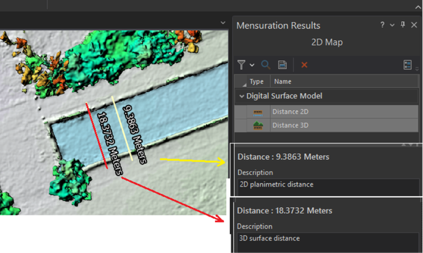
CodyBenkelman_19-1715374440744.png

Example showing both 2D and 3D distance measurements

CodyBenkelman_17-1715374394249.png

3D profile showing the depth of the drainage canal (viewed in the 3D scene)


Improvements for thermal infrared imagery

In our prior release, we enabled creation of True Orthos from thermal infrared (IR) sensors.  In version 2024.1, for those flying DJI drones with thermal IR cameras, pixel values can now be reported in temperature units (degrees Celsius or Fahrenheit).  Note that installation of an additional software package is required to add this support for DJI hardware – see your MyEsri account and you can read more in this blog.

CodyBenkelman_2-1715373522990.png

DJI Zenmuse H20T Thermal True Orthomosaic processed in Drone2Map 2024.1


Smart processing improvements

Our development team has applied a great effort in this release to help users understand and avoid the most common problems encountered when working with a large variety of drones and conditions. 

ArcGIS provides support for nearly every known coordinate system, but sometimes users are unsure of coordinate transformations that may be required for their project data.  In Drone2Map version 2024.1, the Select Transformation drop-down list now displays messages that indicate whether any transformation is needed, which default transformation is being applied, or whether a transformation is needed but not found. The ArcGIS coordinate system data can be installed if necessary for additional transformations.
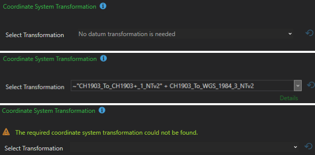
CodyBenkelman_3-1715373522992.png

Two additional information messages relate to helping ensure horizontal and vertical accuracy.  Our typical best practice advice is to always use Ground Control Points (GCPs), but with the increased use of high accuracy GPS in form of RTK or PPK, attempting to add control can negatively impact processing.  Drone2Map 2024.1 will now warn users who attempt this, and advise them to define GCPs to be Check Points (for verifying post-processing accuracy).

CodyBenkelman_4-1715373522992.png

The additional informational message, related to vertical accuracy, is to warn users if their drone altitude values appear to be incorrect.  This is a very common situation for many commercial drones, and the software will compare the drone’s reported Z values to the elevation of the project site to notify the user of expected errors. 

Learning resources accessible from the app

The processing report now includes hyperlinks in each section title of the report. Clicking a link takes you to the relevant help topic to learn more about that subject.

CodyBenkelman_5-1715373522993.png

New tutorials and blogs have been published that focus on some of the most requested subjects. Some of them are listed on the updated Drone2Map Resources page.

CodyBenkelman_6-1715373523023.png

Stay Connected

If you have questions or ideas, we’d love to hear from you! Visit the Esri Community page and let us know what you think. If you’d like to stay up-to-date on the latest product news and announcements for Drone2Map, make sure to sign up to be on our email list.


more
5 0 142
MarkBarker1
Esri Contributor

Learn more about using inspections and working with RTK data in our latest round of content updates for ArcGIS Drone2Map.

Read more...

more
3 0 83
MarkBarker1
Esri Contributor

With the release of 2024.1, ArcGIS Drone2Map now has enabled additional capabilities for some much-requested DJI thermal cameras. A new optional DJI thermal camera support installation package can be installed alongside Drone2Map. It can be found on My Esri under the same location as the main installation files. This is not required for True Ortho processing, but installing this package allows imagery from the specific DJI sensors to be recognized properly when creating new projects and enables Drone2map to report pixel values in temperature units in the thermal True Orthomosaic.

MarkBarker1_0-1715179780642.png

Figure 1: DJI Zenmuse H20T Thermal True Orthomosaic processed in Drone2Map 2024.1

 ©2020 Rocky Mountain Unmanned Solutions


This support is for the following sensors:

Zenmuse H20N

Zenmuse H20 Series

Matrice 30 Series

Mavic 2 Enterprise Advanced

DJI Mavic 3 Enterprise

For more information on the DJI Thermal SDK please see the following: DJI Thermal SDK

more
5 4 220
MarkBarker1
Esri Contributor

Learn about new features, workflow tips and troubleshooting in our latest round of blogs for ArcGIS Drone2Map.

Read more...

more
2 0 562
CodyBenkelman
Esri Regular Contributor

Drone2Map 2023.2 is available, with some important new features!

Read more...

more
3 0 629
MarkBarker1
Esri Contributor

Learn about new features, workflow tips and troubleshooting in our latest round of blogs for ArcGIS Drone2Map.

Read more...

more
1 1 867
KatieSmith
Esri Regular Contributor

Imagery in Action is Esri's newest no-cost massive open online course (MOOC). Join the course to explore authentic workflows used to gain insight and create decision-support products from imagery and remotely sensed data. You'll even get to test out ArcGIS Drone2Map and other ArcGIS software.

Read more...

more
0 0 483
JavierSosa
Esri Contributor

Site Scan Flight for ArcGIS- LE has just released and is now available to all Site Scan users. This release includes support for a new drone, a new flight speed setting for your projects and major improvements to mission planning and execution that we are excited to share with you. 

What’s new in this release? 

  • DJI M300RTK with P1 camera support 
  • Defining mission area from a polygon 
  • Flight speed setting 
  • iOS 15.4.1 support 
  • Retire support for the H520-G drone and the Zenmuse Z30 camera 
  • Additional bug fixes 


New Drone Support 

DJI M300 RTK with P1 sensor support 

JavierSosa_0-1651009428797.png


Support for the DJI Matrice 300RTK with the P1 mapping camera is here! One of the most requested drones to add to the Flight LE app’s supported drones lineup has finished development and testing, and we are excited for you to start using your M300s in Site Scan Flight LE. The M300RTK offers up to 55 minutes of flight time and increases your mapping efficiency. The P1 camera captures high resolution images at 45 MP, allowing you to fly higher and capture large areas faster, while still creating the same resolution outputs as before with lower resolution sensors.


Mission Planning 

Define a mission area from a polygon 


Another user requested update, Site Scan LE now allows you to use polygons saved in ArcGIS Online, or ArcGIS Enterprise as your mission area. 

Previously, you were able to view a polygon layer when planning your flights but had to manually trace the mission area over it. Now, simply display the desired polygon showing the area to be mapped and tap the area to automatically use it as your mission area boundary. 

Defining a mission area from a polygon is useful when planning missions over complex areas, improves collaboration when mapping areas assigned by other members of your organization, and saves time when creating new flight plans. 

Here’s how you can get started with this new feature: 

Note: This feature is available only for Area Survey and Crosshatch Survey flight modes. 

Using an ArcGIS Online or ArcGIS Enterprise polygon layer: 

  1. Choose Area Survey or Crosshatch Survey 
  2. Enter a Mission Name and tap Next 
  3. Tap Define Mission Area from Polygon 
  4. Select ArcGIS Layers 
  5. Sign in with your ArcGIS Online or ArcGIS Enterprise account 
  6. Toggle on the feature layer of interest. If your feature is saved in a web map, you may instead toggle on the web map containing the feature layer 
  7. On the Map, tap on the desired polygon for the mission area. Site Scan will automatically use this as your mission boundary 

Note: If your feature layer contains multiple polygons, you must select one to be used as your mission boundary. 


Flight speed setting 


Site Scan Flight LE automatically optimizes the drone’s flight speed to ensure sharp images are captured and no images are skipped. These are key elements to process your images into high quality and high accuracy data products. The drone and camera model, flight height and overlap settings all affect the preselected flight speed. With this update, you can now view the default flight speed and manually adjust it to make the drone fly faster or slower. 

This setting will allow pilots to increase the drone’s speed by up-to 50% to perform missions within a shorter amount of time, when capturing video for example. You can also reduce the speed down by 50% if you are flying in low light conditions with a reduced camera shutter speed. 

The new speed setting is located in the Advanced Mission Settings for all automated flight modes. 

more
1 0 953
86 Subscribers