- Home
- :
- All Communities
- :
- Products
- :
- Data Management
- :
- Data Management Questions
- :
- Re: Multiple hatches with the same value on a line
- Subscribe to RSS Feed
- Mark Topic as New
- Mark Topic as Read
- Float this Topic for Current User
- Bookmark
- Subscribe
- Mute
- Printer Friendly Page
Multiple hatches with the same value on a line
- Mark as New
- Bookmark
- Subscribe
- Mute
- Subscribe to RSS Feed
- Permalink
- Report Inappropriate Content
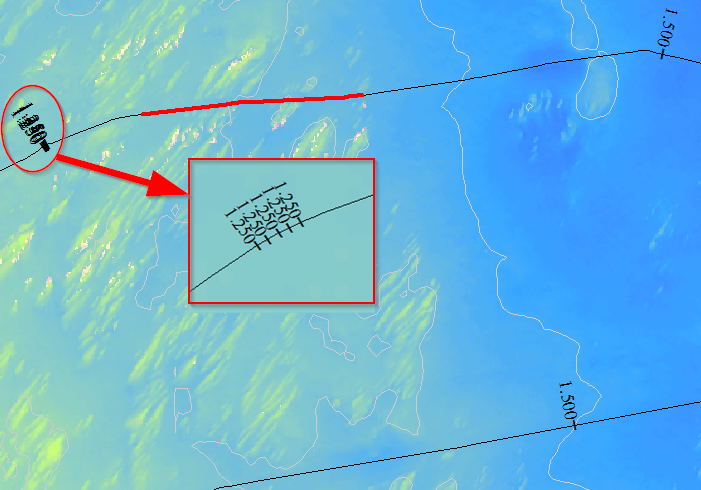
After calibrating a route, I have some of the hatches showing multiple times. When zoomed in they show real close together as illustrated in the image below. Does anyone have seen this before, and know what the solution is to remove those multiple hatches, and make sure of a correct calibration?
Thanks in advance!
GIS for Hydrographic Surveying
Solved! Go to Solution.
- Mark as New
- Bookmark
- Subscribe
- Mute
- Subscribe to RSS Feed
- Permalink
- Report Inappropriate Content
Yes M resolution is 0.0001, tolerance is 0.001
If I increase tolerance/resolution, the problem stays.
- Mark as New
- Bookmark
- Subscribe
- Mute
- Subscribe to RSS Feed
- Permalink
- Report Inappropriate Content
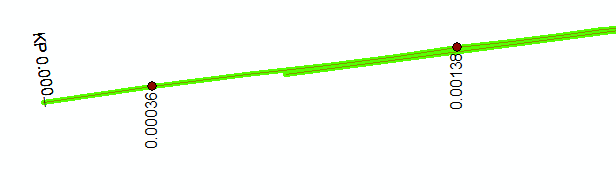
That explains your second image, Difference in measure between your calibration points is 0.00102 because of your tolerance (0.001) value there is no change in measure between these two calibration point. That's why you are getting measure between these points as 0.000
Try creating a new feature class with tolerance 0.00001 and resolution 0.000001. You should get different measure at your hatches.
- Mark as New
- Bookmark
- Subscribe
- Mute
- Subscribe to RSS Feed
- Permalink
- Report Inappropriate Content
Problem solved, I forgot to increase the M-resolution for the line feature itself. I only increased the resolution for the calibration points!!
Thanks for the help!!
- Mark as New
- Bookmark
- Subscribe
- Mute
- Subscribe to RSS Feed
- Permalink
- Report Inappropriate Content
Hi Arnold,
How about the hatches in your first image, has it gone as well?
- Mark as New
- Bookmark
- Subscribe
- Mute
- Subscribe to RSS Feed
- Permalink
- Report Inappropriate Content
Here is the answer: Thanks again for all the help!!
- Mark as New
- Bookmark
- Subscribe
- Mute
- Subscribe to RSS Feed
- Permalink
- Report Inappropriate Content
Interesting!!! Now i'm out of reasons  . Can you post a subset of your route feature and calibration points where you have issues. I'll have a closer look.
- Mark as New
- Bookmark
- Subscribe
- Mute
- Subscribe to RSS Feed
- Permalink
- Report Inappropriate Content
Start an edit session and look at the M values for the vertices along that line in that area.
- « Previous
-
- 1
- 2
- Next »
- « Previous
-
- 1
- 2
- Next »