- Home
- :
- All Communities
- :
- Products
- :
- Imagery and Remote Sensing
- :
- Imagery Questions
- :
- Re: Convert an Orthomosaic to vector
- Subscribe to RSS Feed
- Mark Topic as New
- Mark Topic as Read
- Float this Topic for Current User
- Bookmark
- Subscribe
- Mute
- Printer Friendly Page
Convert an Orthomosaic to vector
- Mark as New
- Bookmark
- Subscribe
- Mute
- Subscribe to RSS Feed
- Permalink
- Report Inappropriate Content
Greeting
I am Msc student in surveying engineering, I have generated an orthomosaic.tiff (its size 4.5GB) and DTM.tiff (its size 2.5GB) using Pix4D software, I need to making a vectorization to dwg or dxf in order to produce a linemap, I have tried many time to do such conversion using:
AcrToolbox->conversion tools->from raster to ployline, OR raster to polygon.
Unfortunately after a few hours of conversion nothing will display and converted file is empty.
Could you please clarify the procedure if this type of conversion is possible.
- Mark as New
- Bookmark
- Subscribe
- Mute
- Subscribe to RSS Feed
- Permalink
- Report Inappropriate Content
Generally, yes, it is possible using the tools you mentioned. But there can be issues with running out of memory. I've never processed images as large as what you have, but have had smaller ones blow up due to memory issues. One workaround was to split the images into several pieces, Raster to Polygon each piece separately, then rejoin the results (and then clean up the results where they joined).
Here's some folks who probably have more detailed ideas:
Chris Donohue, GISP
- Mark as New
- Bookmark
- Subscribe
- Mute
- Subscribe to RSS Feed
- Permalink
- Report Inappropriate Content
Dear Chris
I have separated this large size to a number of smaller tiles (200MB approx.), after separation I have tried to convert (Raster to Polygon), again the file is empty and nothing will display.
So,now what should I do?
- Mark as New
- Bookmark
- Subscribe
- Mute
- Subscribe to RSS Feed
- Permalink
- Report Inappropriate Content
You need to somehow generalize your imagery before you try to extract vectors from it.
Can you describe your orthomosaic? I'm picturing RGB or multispectral imagery - raster to polygon will try to draw a pixel-sized polygon around every pixel value, which is a lot of polygons. I assume you will want to first classify your raster, then clean up the classification, then export to polygons.
As for you DTM, I assume you want contour lines. You can get them using the Contour tool.
- Mark as New
- Bookmark
- Subscribe
- Mute
- Subscribe to RSS Feed
- Permalink
- Report Inappropriate Content
- Mark as New
- Bookmark
- Subscribe
- Mute
- Subscribe to RSS Feed
- Permalink
- Report Inappropriate Content
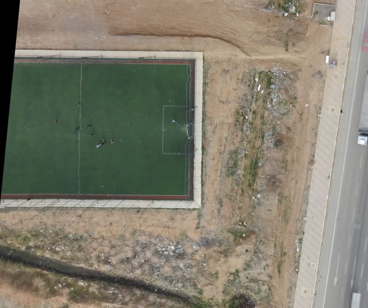
Dear Dareen
Above is orthomosaic with GSD of 2.4cm, also I have created contour line FYI.
- Mark as New
- Bookmark
- Subscribe
- Mute
- Subscribe to RSS Feed
- Permalink
- Report Inappropriate Content
I have classified generated DSM for DTM extraction using Pix4D software, is it possible to utilize this classification instead of reclassification by Arc Map?
- Mark as New
- Bookmark
- Subscribe
- Mute
- Subscribe to RSS Feed
- Permalink
- Report Inappropriate Content
I'm not familiar with Pix4D software and don't know what the classification would be. If it's classified into the categories you're interested in having as polygons, then that would be it. What exactly do you want to export to vector? There is no function that means "export this image to vector and you (ArcGIS) need to figure what I mean by that". Do you want to extract by color (perhaps through a supervised or unsupervised classification), or maybe edges, or something else?
- Mark as New
- Bookmark
- Subscribe
- Mute
- Subscribe to RSS Feed
- Permalink
- Report Inappropriate Content
Darren
Okey I will reclassify using Arc Map, let me know how can I do?
What I want to export to vector is only edges/corners of features (like playing yard, house, road, walkway, etc) as you see in the screenshot sketch.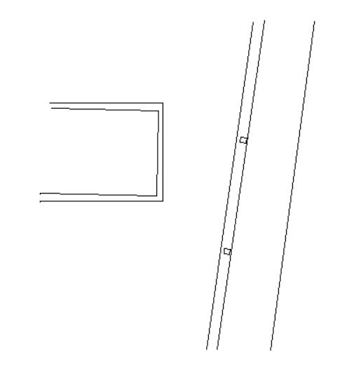
- Mark as New
- Bookmark
- Subscribe
- Mute
- Subscribe to RSS Feed
- Permalink
- Report Inappropriate Content
Dear Dareen
Still I am waiting your recommendation about extracting ONLY edges of features.