- Home
- :
- All Communities
- :
- Products
- :
- Mapping
- :
- Mapping Questions
- :
- Re: Changing Map Units
- Subscribe to RSS Feed
- Mark Topic as New
- Mark Topic as Read
- Float this Topic for Current User
- Bookmark
- Subscribe
- Mute
- Printer Friendly Page
- Mark as New
- Bookmark
- Subscribe
- Mute
- Subscribe to RSS Feed
- Permalink
- Report Inappropriate Content
I need to calc degrees minutes seconds formats for latitude & longitude coordinates in a point feature class projected as NAD83 state plane Oklahoma, south, Feet. I received a very helpful answer from Neil Ayres, earlier this week, to my query on how to use the data frame GCS North American 1983 and calc geometry to calc the coordinates for a feature class projected as NAD83 State Plane Oklahoma, feet. Unfortunately, since the decimal degrees option is greyed out for the data frame that is the format the calc geometry tool calcs. How can I calc or change decimal degrees lats and longs to deg min sec format. I've tried, unsuccessfully, doing project to change the fc projection to another that would allow a change to the desired format.
Ken
Solved! Go to Solution.
Accepted Solutions
- Mark as New
- Bookmark
- Subscribe
- Mute
- Subscribe to RSS Feed
- Permalink
- Report Inappropriate Content
- Mark as New
- Bookmark
- Subscribe
- Mute
- Subscribe to RSS Feed
- Permalink
- Report Inappropriate Content
- Mark as New
- Bookmark
- Subscribe
- Mute
- Subscribe to RSS Feed
- Permalink
- Report Inappropriate Content
As Dan_Patterson says, the Convert Coordinate Notation tool will allow you to add XY in DMS, DM, etc. These are coordinate "notations", ways of describing the lat/long. They cannot actually be used as input into the GIS directly as coordinates, because they are not a number, but a string representation.
- Mark as New
- Bookmark
- Subscribe
- Mute
- Subscribe to RSS Feed
- Permalink
- Report Inappropriate Content
This is the first time I've heard of the convert coord not tool. After an hour of online research, before I posted my ques, I'd not found any mention of the tool. I'd still be hung up without Dan and Neil's replies. After several tries here's the procedure that worked for me:
I projected a blank arcmap to GCS North Amer 83 - I added in my point fc, NAD83 Stateplane Ok, feet - I set the tool up as follows:
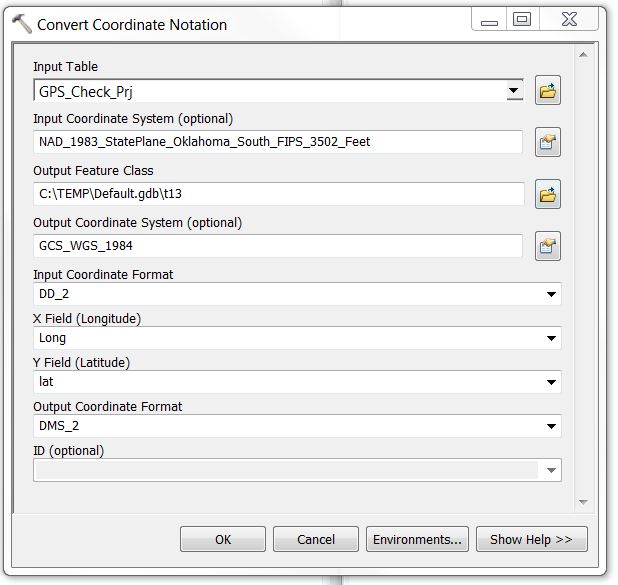
thank all of you who advised me
- Mark as New
- Bookmark
- Subscribe
- Mute
- Subscribe to RSS Feed
- Permalink
- Report Inappropriate Content
Ken, just as a heads up, there are a couple bugs in this tool.
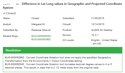
Looks like these are schedules to be fixed in v10.5 (tentative release early next year last I heard)
- Mark as New
- Bookmark
- Subscribe
- Mute
- Subscribe to RSS Feed
- Permalink
- Report Inappropriate Content
Rebecca,
Thank you so much for commenting. I've not checked the position of
the coords provided by the notation tool.
2 meters is a problem for me, so I'll check some of the positions
and, if they are off that far, I'll make a note to change them after
the bug is fixed, so the coords don't get truncated as much.
I appreciate you looking out for me,
Ken